Project Gutenberg's The Rand-McNally Bible Atlas, by Jesse L. Hurlbut

This eBook is for the use of anyone anywhere at no cost and with
almost no restrictions whatsoever.  You may copy it, give it away or
re-use it under the terms of the Project Gutenberg License included
with this eBook or online at www.gutenberg.org


Title: The Rand-McNally Bible Atlas
       A Manual of Biblical Geography & History
Project Gutenberghttp://www.gutenberg.org/files/41140/41140-h/41140-h.htm Author: Jesse L. Hurlbut Illustrator: Rev. Bishop John H. Vincent Release Date: October 22, 2012 [EBook #41140] Language: English Character set encoding: ISO-8859-1 *** START OF THIS PROJECT GUTENBERG EBOOK THE RAND-MCNALLY BIBLE ATLAS *** Produced by Emmy, Kevin Handy, John Hagerson and the Online Distributed Proofreading Team at http://www.pgdp.net

Transcriber's Note: Larger versions of this and most other maps may be seen by clicking on the image. This is also true of some of the larger and more detailed colored charts.
BIBLE ATLAS
A MANUAL OF
Biblical Geography and History
ESPECIALLY PREPARED
For the Use of Teachers and Students of the Bible, and for Sunday School Instruction, containing
For the Use of Teachers and Students of the Bible, and for Sunday School Instruction, containing
Maps, Plans, Review Charts, Colored Diagrams,
AND
ILLUSTRATED
WITH ACCURATE VIEWS OF THE PRINCIPAL CITIES AND LOCALITIES KNOWN TO BIBLE HISTORY.
REVISED EDITION.
REVISED EDITION.
BY REV. JESSE L. HURLBUT, D. D.,
Author of "Revised Normal Lessons," "Studies in the Four Gospels," "Studies in Old Testament History," etc.
WITH AN INTRODUCTION BY
REV. BISHOP JOHN H. VINCENT, D. D., LL. D.,
Chancellor of the Chautauqua University.
CHICAGO:
RAND, McNALLY & COMPANY,
PUBLISHERS.
WITH AN INTRODUCTION BY
REV. BISHOP JOHN H. VINCENT, D. D., LL. D.,
Chancellor of the Chautauqua University.
CHICAGO:
RAND, McNALLY & COMPANY,
PUBLISHERS.
MANUAL OF BIBLICAL GEOGRAPHY.
Copyright, 1884, by Rand, McNally & Co.
Copyright, 1887, by Rand, McNally & Co.
Copyright, 1899, by Rand, McNally & Co.
Copyright, 1908, by Rand, McNally & Co.
Copyright, 1910, by Rand, McNally & Co.
Copyright, 1884, by Rand, McNally & Co.
Copyright, 1887, by Rand, McNally & Co.
Copyright, 1899, by Rand, McNally & Co.
Copyright, 1908, by Rand, McNally & Co.
Copyright, 1910, by Rand, McNally & Co.
INTRODUCTION.
On this side of the sea we sit down with a big book in our hands. It is an old book. Nearly two thousand years have passed since the last word of it was written, and no one can tell how many thousands of years ago the records were made or the words uttered, out of which its first writer prepared his wonderful statements.
This old book is a singular book as to the variety of its contents,—ranging from dry chronological statement to highest flight of royal poetry. Many pages of it are simply historical, with lists of kings, and names of family lines through many generations. Geographical allusions descending to minutest detail are strewn thickly through its pages. There is no department of natural science which does not find some of its data recognized in the chapters of this venerable volume. Stones and stars, plants and reptiles, colossal monsters of sea and land, fleet horse, bird of swift flight, lofty cedar and lowly lily,—these all find their existence recognized and recorded in that book of "various theme."
As it is a long time since these records were made, so are the lands far away in which the events recorded are said to have occurred. We measure the years by millenaries, and by the thousand miles we measure the distance. The greatest contrast exists between the age and land in which we live and the age and lands in which this book found its beginning, its material and its ending.
To one familiar only with the habits, dress and customs of American life, the every-day events recorded in the book seem fabulous. We do not dress as the book says that people dressed in those far-away years and far-away lands; we do not eat as they did; our houses are not like theirs; we do not measure time as they did; we do not speak their language; our seasons do not answer to the seasons that marked their year. It is difficult, knowing only our modern American life, to think ourselves into the conditions under which this book says that people lived and thought in those long-ago ages. Their wedding feasts and funeral services differed utterly from ours. They lived and died in another atmosphere, under a government that no longer exists; made war upon nations that are powerless to-day as the sleeping dead in a national cemetery; and the things which we read concerning them seem strange enough to us.
In the changes which have taken place through all these centuries, it would be an easy thing, under some circumstances, for men to deny that the people of the book ever lived, that the cities of the book were ever built, that the events of the book ever transpired. And, if its historic foundation were destroyed, the superstructure of truth, the doctrinal and ethical teachings resting upon it, might in like manner be swept away.
This old Book—the Bible, a divine product, wrought into the texture of human history and literature with the gradually unfolding ages—is the old Book we study to-day on this side the sea.
It is a "Book of books,"—the Book out-shining all other books in the literary firmament, as the sun out-splendors the planets that move in their orbits around him.
It is a book that deals with man as an immortal soul; making known the beginnings of the race; going back of the beginning to God, who is from "everlasting to everlasting," and who "in the beginning created the heaven and the earth"; revealing the creative purpose and loving grace of God; tracing the fall and deterioration of man, the divine interposition in human history, the preparation of a family, a race, a nation, and a world at large, for the coming of the Redeemer; revealing the glory of God in the face of Jesus Christ; showing how the Christ came, what he did, what he said, what he resisted, what he endured, what he suffered, what he achieved; telling in simple way the story of the early church, from the little meeting of the bereaved disciples in the upper room to the magnificent consummation of Christ's coming, as seen in the prophetic visions of St. John on the Isle of Patmos.[iv]
It is a book full of history, of geography, of archæology, of prophecy, of poetry, of doctrine, of "exceeding great and precious promises."
In an important sense the foundations of this book are laid in human history and geography. However high toward the heavens it may reach in doctrine and promise, its foundations lay hold of the earth. If the children of Israel did not live in Egypt and Canaan and the far East, if the statements of their history as recorded in the book be not facts, if the story of Jesus Christ be false,—everything fails us. With the sweeping away of fact, we must also bid farewell to the words of doctrine and of promise here recorded; to the divine words of assurance which now give comfort to the penitent, hope to the despairing, strength to the feeble, and immortal life to the dying.
As we sit down on this side of the sea, it is well that we are able to look beyond the sea to the lands which gave to the world the book in our hands. And it is well, that, as we look, we are able to connect the book of to-day with those same lands as they now lie among the rivers and by the seaside, from the sources of the Tigris and Euphrates to the mouths of the Nile, from the palaces of Babylon to the dock at Puteoli and the prison at Rome. And it is well that the lands as they are found to-day correspond to the records of the Book as they were made centuries and centuries ago. The Book, on its human historic, geographical and archæological side, is true to the facts as in the nineteenth century they are presented to us in the lands of the East.
There are those who believe with firm faith, that, for these days of skepticism and of merciless and conscienceless historic criticism, the lands have been kept almost in their original condition, that the testimony of the modern skeptical traveler might (though unintentionally on his part, but necessarily) corroborate the teachings of the Bible. Have the mummy wrappings of Mohammedan domination held the far East unchanged through the centuries, that in these days of doubt the hills of Canaan, the plains of Egypt and the ruins of Mesopotamia might lift their voice in solemn attestation to the divine truthfulness of the sacred historians?
These lands are memorial lands. They are now what the Book says they once were. Although the sweeping away of ancient governments and the reign of anarchy have modified the face of the country, the evidences still remain that the most glowing descriptions of their prosperity were not exaggerated. Infidels have doubted, for example, whether Palestine could contain the immense populations which, in its prosperous days, according to the statements of the Book, were resident there. But scientists show that the soil of Canaan, under cultivation, is one of the richest and most fertile in the world. The broken terraces that may still be traced on the hill-sides, the walls of cities and other ruins that fill the land, sustain the account of the prosperous days and the immense populations of Bible times.
So little have the conditions of social life been modified, that one may live the old life over again in Canaan. Soil and scenery, the seasons of the year, Jacob's well and the Jordan, Ebal and Gerizim, the plain, the wilderness and the city, all give witness to the words of the Book.
The names of olden time still linger. One lands at Yafa, the "Joppa" of old; Jerusalem is now el Khuds,—"the Holy"; Bahr-lut—"the Sea of Lot"—is the Dead Sea in the Valley of Sodom and Gomorrah; Bir es Seba is the Beersheba of the olden time; el Azariyeh is Bethany, the home of Lazarus; Beit-lahm is still Bethlehem; and el Khalil—"the Friend"—is the name of Hebron, the home of Abram, "the Friend of God."
In the customs and costumes, in the habits of speech and the manners of the people, you read the same lesson. In the spring of 1863 I was permitted to spend forty days and forty nights in Palestine. I saw Abraham at his tent-door; Rebekah vailing herself at the approach of the stranger; the long caravan of camels and Midianites on their way toward the South. I saw the wailing mourners at the house of death; the roof that might easily have been broken up; the wedding procession; the grass on the house-tops; the sparrow making a nest for her young in the synagogues of Jerusalem. I saw the elders in the gates; David the shepherd, with his sheep, on the hill-side; the Jewish mother teaching Timothy the words of the old Book in the old city on the hill. Verily, it is the old land; it is the old life; it is the memorial presentation in concrete form of what the Book says was true there thousands of years ago.
As I stood on Safed, overlooking the Sea of Galilee and the lovely land about it, I turned and looked toward the north, and saw snow-sheathed Hermon, probably the Mount of Transfiguration, as it stood out that day against the blue sky of Syria. I thought of Ruskin's words: "These pure white hills, near to[v] the heavens and sources of all good to the earth, are the memorials of the light of his mercy that fell snow-like on the Mount of Transfiguration."
I once saw the Alps glorified by the setting sun. I was standing on La Flégére, looking down upon the Valley of Chamounix, and upward upon the magnificent heights, above which towered the great Mont Blanc. A pall of mist had hidden the rough and unilluminated rocks; but, when that mist grew thin as a vail of delicate lace, I saw the Alps beyond, and they appeared as if on fire. I cried out in ecstacy, "Behold Mount Zion." Through the mists of earth I saw the splendors of heaven. The story of the transfiguration on Mount Hermon, in the days of Jesus, if taken literally, is not so marvelous as the history we call the life and character of Jesus. Both belong to the realm of the supernatural. The "life" granted, the transfiguration has no surprise in it. So I discover the strange blending of the natural and supernatural in the Land and the Book,—in the Land as to-day hallowed by the Book,—in the Book as to-day supported and made real by the Land.
It thus easily appears that every Bible reader should be acquainted with the outlines of Biblical and geographical antiquities. Without such knowledge it is impossible properly to understand the divine word. How often, through ignorance of sacred archæology, we overlook the force and beauty of the allusions which abound in the narrative, poetic and prophetic parts of Scripture. And there is, moreover, an air of reality imparted to all history by familiarity with the geography involved in it.
In view of the supernatural character of Bible history, acquaintance with Bible geography is particularly important. Once give its wonderful transactions an actual locality among the hills, valleys and cities which may still be found and visited, connecting and comparing them with the records of our present history, and our youth will readily distinguish the miraculous from the mythical, and discover not only clear illustrations of many portions of the Bible, but strong and irresistible evidence in favor of its divinity.
I therefore hail with joy the admirable presentation of the facts of Bible history and geography in this volume—a presentation so clear, and so abundantly illustrative, that the humblest teacher and most indifferent student may be interested and instructed.
The study of Bible history and geography must not be limited to the theological school, the pastor's study, or the advanced Bible class. It is a department peculiarly adapted to our youngest children, and by them most needed, that they may secure the vivid realization of actuality in the Bible narratives. Boys and girls to-day may not take much delight in the advanced doctrinal teachings of the Bible; but it is possible so to connect its history with stories of modern travel, through the regions referred to in that history, that they will become interested in the one because of the pleasure they find in the other.
Our Sunday School libraries should contain the many books of travel through the far East which are published in these days. And our ministers should enlist young people, through special classes, in the study of Bible history and geography. In this way a "week-day hold" upon our young people may be secured.
During ten years of my pastoral life, wherever the itinerant system of my church placed me, I held on every Saturday afternoon, in the lecture-room of my church, a class to which old and young, and the representatives of all denominations, were admitted. It was called "The Palestine Class," and was devoted to the study of Bible history and geography. An outline of facts, prepared in catechetical form, was printed, and committed to memory by every pupil. Difficult old Hebrew names of lands, cities and mountains, were arranged in a rhythmic way, and chanted after the manner of the old-time "singing geography" classes. Answers were given in concert to help the memory, and personal examinations were afterward conducted to test it. The class constituted an "ideal company of tourists to the far East." The course of lessons was divided into five sections, covering the whole of Bible history. As each member, passing a personal examination, gave proof that he had thoroughly mastered "Section One," he was constituted a Pilgrim to the Holy Land, and given a certificate to that effect. Having studied "Section Two," and passed a satisfactory examination, he was made a Resident in Palestine, and his name was associated with one town or mountain. In that way every principal place on the map was associated with the name of some member, who was held responsible to the class for information concerning its history and present condition. An examination in "Section Three" made our "pilgrim" and "resident" a Dweller in Jerusalem. Having been examined in "Section Four," he was made an Explorer of other Bible lands, and was located on some mountain, or city of Egypt, Arabia, Chaldea, Asia Minor, etc. A final examination made him a Templar.[vi]
The songs, concert exercises, responses and ideal pilgrimage gave enthusiasm to the class, while the personal examinations guaranteed thoroughness. As I recall those Saturday afternoons of my early ministry, surrounded by earnest women and wide-awake boys and girls of all ages, I am amply rewarded for all the labor and time expended. The enthusiasm and delight, the perceptible growth in knowledge, the spirit of catholicity, the steadiness promoted in the frivolous, the gratification afforded on the occasion of public examinations and reviews, the increased appreciation of the Sunday preaching, visible on the faces of young and old, the grateful words that have come through the intervening years from those who were by these studies incited to a more intelligent and earnest Bible study—these are some of the results of those years of pastoral service. The plan is practicable for every pastor. The book which I now have the honor of introducing to the public furnishes to every minister a complete preparation for directing such classes—a preparation which, twenty-five years ago, would have been a great benediction to me.
One of these Palestine classes reported its imaginary tour through the village paper. These articles gave local interest to the movement, delighting the imaginary tourists, and (through no fault of ours) deceiving more than one simple-hearted reader in the community. From these letters I make a few extracts.
"PALESTINE CORRESPONDENCE OF THE 'INDEPENDENT WATCHMAN.'
"Dear Independent: In fulfillment of the promise made the night before our departure, I sit down to write the first of a series of letters detailing the most noteworthy incidents of our journey to the Holy Land, with such historical and geographical facts as are suggested by the localities we may be permitted to visit.
"As you are well aware, an association, which has for its specific object the study of Bible history and geography, was organized in your town some months ago. After a course of thorough preliminary training, arrangements were consummated for a tour of observation through Egypt, Arabia, Palestine,—the lands of Hebrew life and literature, the scenes of the early Christian history, and, later, the arena of Saracenic invasion and domination. We are now on the way thither. While the tide of mighty immigration is pouring westward toward the American desert, the Rocky Mountains, Pike's Peak and Cherry creek, a tiny rill of exploration is trickling eastward toward the desert of Sinai, the mountains of Egypt, the peaks of Lebanon, and the river of Jordan." * * * * *
After calling attention to two books which had just then appeared—"The Land and The Book," by Dr. Thomson, and "Palestine Past and Present," by Dr. Osborn—the Palestine correspondent continued:
"No class of literature is more refining and exalting than the records of cultivated minds made amid the sacred scenes of Palestine, and the not less interesting ruins of Egypt, Asia Minor and Greece. A taste for such mental pabulum is a better safeguard against the popular and polluting fictions of the day than all the mandates of the parent or the uncompromising denunciations of the pulpit. Preoccupy by the good, and there will be no evil to expel. Create a taste for healthful literature in our young people, and they will not crave the blood and fire potions now so mercilessly provided by the corrupt press. This is one object of our present pilgrimage to Palestine. We would open a new world—the newest and yet the oldest of worlds—to their view. We would unfurl bright maps and open new books, and delight them in a field of thought and research, in which healthful influences prevail, a field of fragrant and thornless flowers, of luscious and life-giving fruit. * * * * * The association to which I have referred is composed of about eighty pilgrims. On Saturday morning, the 25th, we left your quiet village, reaching Chicago the same evening. Tuesday morning found us on our way to New York, where we arrived early this morning. We shall sail on Saturday, April 2, for the Orient. In order to diminish our expenses, we forego the speed of the regular steam route, and have chartered the sailing vessel, the schooner 'Star of Bethlehem.' She is a new vessel, and a 'bright light' in her way. Well rigged, and ably manned, she is prepared for the buffeting of old ocean. Her captain is the distinguished and experienced Hardstudy, with whom, I am sure, you have some acquaintance. He is a true gentleman, and, I am told, has been an intimate companion of several Oriental travelers. He accompanied Dr. Robinson on both his tours. The 'Star,' built expressly for excursions to the Mediterranean waters, is a stout boat, and is provided with the modern conveniences and luxuries of travel. She is about 150 tons burden. I spent an hour on board of her this afternoon, and am much gratified with the neatness and elegance displayed in all her departments. The library and reading-room is a little palace. It contains about 1,500 volumes, chiefly of Eastern travel, which, together with a number of good maps and paintings, will afford us every opportunity to prepare for the interesting tour we are about making. All thus far are well. Remember us in our wanderings, and send us copies of your paper, directing to the 'care of the United States Consul at Alexandria.' Prepay to New York, and send 'Via Liverpool and Beyrout.'"
The next letter gives an account of the various pilgrimages which have been made to Palestine from the days of Abraham down to the present.
"Off Sandy Hook, 3.30 p. m.," our correspondent wrote. "The wide ocean is before us. We have passed the Battery, Brooklyn, Staten Island, the ruins of old quarantine and the forts,—feeble protection in cases of invasion,—and yonder to the east is Sandy Hook. The bell of the tug rings. In five minutes our friends who accompany us down will return to the city, and we shall be alone upon the wide, wide sea. The waters appear quiet; a faint west wind is rising; all the children are in good spirits. If they are as bright to-morrow it will be strange. Farewell, native land! Farewell!"
The third letter opened with a quotation from Browning:
"'In the dimmest northeast distance
Dawned Gibraltar, grand and gray.'
Dawned Gibraltar, grand and gray.'
"Schooner Star of Bethlehem,
"Harbor of Gibraltar, May 4, '59.
"Dear Independent: Thirty-two days ago we left the port of New York, and day before yesterday glided through the Straits of Gibraltar, casting anchor in this harbor. Our voyage was short and agreeable, all that could be desired, with the exception of the sea-sickness that prevailed among us for the first four or five days, and the alarm occasioned by the heavy gale of last week. For two days the storm raged so violently that our fears were much excited. On the evening of the 26th ult. the winds were lulled, the clouds broke away, and the rays of the setting sun hurried swiftly across the yet raging waves, to brighten their foaming crests with golden light, and bring hope to our hearts. Religious services were conducted each Sabbath by the chaplain, and our programme of study and reading was faithfully observed every day. All that we did, and all that we saw, cannot be reported in a single letter. Our young friends must themselves write about the wonders of the sea,—whales, dolphins, icebergs; sunset, sunrise, midnight; calms, storms, water-spouts; and all other sources of joy or terror in ocean life. Yesterday was spent in an excursion to the town of Gibraltar." * * * * *
After a description of Gibraltar, the writer says:
"The whole juvenile forces of our vessel have been invited to dine this afternoon with the officers of H. M. S. Manchester, in company with the British and American consuls of Gibraltar, and left an hour ago, under the charge of Captain Hardstudy, to comply with the gracious invitation, and I remain to prepare this letter for the morrow's steamer from Valetta to Liverpool. The sun is already sinking in the blue and gold waters of the Mediterranean. A fresh breeze has startled the sleeping waves into lively gambols, and our flag points eagerly westward and homeward. See our party of little travelers just off for the 'Manchester'! How their boats dance up and down over the water! 'Boom!' 'boom!' go the signal guns from the kind old ship! Now hear the thunderous volleys from the batteries on the huge mountain, proclaiming the hour of sunset!"
The letters which follow are from "Alexandria, Egypt, May 28"; from the "Steamer Rameses, River Nile, June 11"; from "Off Joppa, June 16"; from "Jerusalem, July 5"; from "Nablous, 'the City of Samaria,' July 12"; from "Beyrout, Syria, July 23"; and on Monday morning, July 25, our correspondent writes his farewell, as follows:
"Well, friend Independent, our travels are ended. We came on board the 'Star of Bethlehem' this morning. The steamer for Liverpool leaves this afternoon, and we shall send our letters ashore to be mailed. By the 30th of September we hope to be with you again. We have seen the earthly Canaan, with its degradation and defilement. Our minds turn toward the better Canaan. With Watts we sing:
"'Look up, our souls, pant toward the eternal hills;
Those heavens are fairer than they seem.
There pleasures all sincere glide on in crystal rills;
There not a dreg of guilt defiles,
No grief disturbs the stream
That Canaan knows,—no noxious thing,
No cursed soil, no tainted spring;
No roses grow on thorns, nor honey wears a sting.'"
Those heavens are fairer than they seem.
There pleasures all sincere glide on in crystal rills;
There not a dreg of guilt defiles,
No grief disturbs the stream
That Canaan knows,—no noxious thing,
No cursed soil, no tainted spring;
No roses grow on thorns, nor honey wears a sting.'"
Such devices as these help to inspire the young with an interest in sacred things. They may not yet be prepared to appreciate the night of prayer on the mountain, the agony of the Lord in Gethsemane, or the rapturous experiences of St. John on Patmos; but they may take delight in the land, its customs, its wonderful histories, read with gratification an account of journeys from Dan to Beersheba, with perils from robbers, and the pranks of native children, the lonely horseback ride from Jerusalem down to Jericho, the encampment by the "Fountain of robbers" north of Jerusalem, the loveliness of Nazareth, the beauty of the Sea of Galilee, and the glories of Lebanon and Hermon. Finding delight in these more human things, they may, incidentally, under the leadership of the divine Providence and Spirit, catch glimpses of his face who, by simile and word and spirit, sanctified the land from north to south and from Bashan to the sea.
J. H. VINCENT.
PREFACE TO THE REVISED EDITION.
During the fourteen years since this work was prepared great advancement has been gained in knowledge of the ancient Oriental world. In the light of recent researches it has become necessary to revise the entire book. The work has been done with care, every location has been reinvestigated, and the historical allusions have been compared with the latest and best authorities. In this revision the author has been materially aided by Prof. Robert W. Rogers of Madison, N. J., and Prof. Karl P. Harrington of Chapel Hill, N. C., to both of whom thanks are rendered. It is possible that some errors may yet remain, and if any appear to students who make use of this work, corrections or suggestions with regard to them will be gratefully received.
Jesse L. Hurlbut.
GENERAL INDEX.
| PAGE | |
| Ancient World, and the Descendants of Noah | 23 |
| Apostolic History, Early | 112 |
| Bible History, Chart of | 13 |
| Conquest of Canaan | 50 |
| Empire of David and Solomon | 68 |
| Illustrations, List of | 11 |
| Index to Descriptive Matter | 157 |
| Index to Map of Old Testament World (Map on pp. 18, 19) | 156 |
| Index to Map of Palestine (Map on pp. 152, 153) | 151 |
| Introduction | 3 |
| Isles of Greece and the Seven Churches | 132 |
| Jerusalem, Ancient | 72 |
| Jerusalem, Environs of | 82 |
| Jerusalem, Modern | 77 |
| Journeys of the Apostle Paul | 116 |
| Journeys of the Patriarchs | 33 |
| Kingdom of Saul | 64 |
| Lands of the Sojourn and Wandering | 41 |
| Life of Christ, The | 103 |
| Measures of the Bible, The | 148 |
| New Testament Palestine (Kingdom of Herod the Great) | 100 |
| Old Testament World, The | 17 |
| Oriental Empires, The Great | 91 |
| Palestine Among the Twelve Tribes | 55 |
| Palestine Before the Conquest | 36 |
| Palestine, Lessons in the Geography of | 143 |
| Palestine Under the Judges | 60 |
| Physical Palestine | 28 |
| Roman Empire, The | 97 |
| Solomon's Empire, The Division of | 86 |
| Tabernacle, The | 135 |
| Table of Contents | 9 |
| Temple, The | 138 |
TABLE OF CONTENTS.
| PAGE | ||||
CHART OF BIBLE HISTORY | 13-16 | |||
| I. | General Periods. | |||
| II. | Subdivisions. | |||
| III. | Persons and Rulers. | |||
| IV. | Events of Bible History. | |||
| V. | Battles of Bible History. | |||
| VI. | Events of Religious Progress. | |||
| VII. | The Books of the Bible. | |||
| VIII. | Great Oriental Empires. | |||
| IX. | Events of Secular History. | |||
THE OLD TESTAMENT WORLD | 17-22 | |||
| II. | Seas. | |||
| III. | Mountain Ranges. | |||
| IV. | Rivers. | |||
| V. | Lands. | |||
| I. Lands of the Mountain System. 1. Armenia; 2. Media; 3. Persia. | ||||
| II. Lands of the Plain. 1. Assyria; 2. Elam; 3. Mesopotamia; 4. Chaldea; 5. Arabia. | ||||
| III. Lands of the Mediterranean. 1. Asia Minor; 2. Syria; 3. Phœnicia; 4. Palestine; 5. The Wilderness; 6. Egypt. | ||||
ANCIENT WORLD, AND DESCENDANTS OF NOAH | 23-27 | |||
| I. | The Japhetic Nations. 1. Gomer; 2. Magog; 3. Madai; 4. Javan; 5. Tubal; 6. Meshech; 7. Tiras. | |||
| II. | The Hamitic Races. 1. Cush; 2. Mizraim; 3. Phut; 4. Canaan. | |||
| III. | The Semitic Races. 1. Elam; 2. Asshur; 3. Arphaxad; 4. Lud; 5. Aram. | |||
PHYSICAL PALESTINE | 28-32 | |||
| I. | Dimensions. 1. Canaan; 2. Palestine Proper; 3. The Land of Promise. | |||
| II. | Natural Divisions. 1. Maritime Plain; 2. Mountain Region; 3. Jordan Valley; 4. Eastern Table-Land. | |||
| III. | The Waters of Palestine. 1. The River Jordan; 2. The Three Lakes; 3. The Brooks. | |||
| IV. | The Mountains of Palestine. 1. West of the Jordan; 2. East of the Jordan. | |||
| V. | The Plains of Palestine. 1. Phœnicia; 2. Sharon; 3. Philistia; 4. Esdraelon; 5. Negeb; 6. Jordan; 7. Hauran. | |||
THE JOURNEYS OF THE PATRIARCHS | 33-36 | |||
| I. | The Journeys of Abraham. 1. Ur to Haran; 2. Haran to Canaan; 3. Visit to Egypt; 4. Removal to Hebron; 5. Pursuit of the Elamites; 6. Settlement at Beersheba; 7. Offering of Isaac; 8. Burial of Sarah. | |||
| II. | The Journeys of Isaac. Homes: 1. Beer-lahai-roi; 2. Gerar; 3. Rehoboth; 4. Beersheba; 5. Hebron. | |||
| III. | The Journeys of Jacob. 1. Flight to Haran; 2. Return to Canaan; 3. Residence in Canaan; 4. Descent into Egypt; 5. Burial Procession. | |||
PALESTINE BEFORE THE CONQUEST | 36-40 | |||
| I. | The Earliest Inhabitants. 1. The Rephaim; 2. The Zuzim; 3. The Emim; 4. The Horim; 5. The Avim; 6. The Anakim. | |||
| II. | The Tribes of the Patriarchal Era. 1. Zidonians; 2. Canaanites; 3. Philistines; 4. Hittites; 5. Girgashites; 6. Hivites; 7. Perizzites; 8. Jebusites; 9. Amorites. | |||
| III. | The Nations at the Time of the Conquest. 1. Amorites; 2. Moabites and Ammonites. | |||
| IV. | The Surrounding Nations. 1. Hivites, Arkites, Sinites, Arvadites, Hamathites; 2. Ammonites; 3. Amalekites, Kenites, Edomites. | |||
LANDS OF THE SOJOURN AND WANDERING | 41-49 | |||
| I. | The Land of Egypt. 1. Names; 2. Boundaries and Dimensions; 3. Divisions; 4. The Nile; 5. The People; 6. History; 7. Principal Places. | |||
| II. | The Wilderness of the Wandering. 1. Situation; 2. Natural Features; 3. Inhabitants. | |||
| III. | The Land of Edom. 1. Boundaries; 2. Names; 3. Natural Features; 4. History; 5. Peculiarities. | |||
| IV. | The Wandering in the Wilderness. 1. Rameses to the Red Sea; 2. Red Sea to Mt. Sinai; 3. Mt. Sinai to Kadesh-barnea; 4, 5, 6. Kadesh-barnea to Mt. Hor, Ezion-geber, and Return; 7, 8. Kadesh-barnea to Elath and Jordan; Table of Stations. | |||
THE CONQUEST OF CANAAN | 50-54 | |||
| I. | Conquest of Eastern Palestine. 1. Gilead; 2. Bashan; 3. Midian. | |||
| II. | Conquest of Western Palestine. 1. Central; 2. Southern; 3. Northern. | |||
| III. | Supplementary Conquests. 1. Judah and Simeon; 2. Caleb and Othniel; 3. Dan. | |||
PALESTINE AMONG THE TWELVE TRIBES | 55-59 | |||
| I. | Reuben. | |||
| II. | Gad. | |||
| III. | Manasseh—East. | |||
| IV. | Simeon. | |||
| V. | Judah. | |||
| VI. | Benjamin. | |||
| VII. | Dan. | |||
| VIII. | Ephraim. | |||
| IX. | Manasseh—West. | |||
| X. | Issachar. | |||
| XI. | Asher. | |||
| XII. | Zebulon. | |||
| XIII. | Naphtali. | |||
PALESTINE UNDER THE JUDGES | 60-63 | |||
| I. | Supplementary to the Conquest. 1. Judah and Simeon; 2. Danite Migration; 3. Civil War. | |||
| II. | Oppressions and Judges. 1. Mesopotamian (south) 2. Moabite (central) 3. Early Philistine (south) 4. Canaanite (north); 5. Midianite (central and north) 6. Ammonite (east) 7. Philistine (south and central). | |||
| III. | Battles of the Period. | |||
THE KINGDOM OF SAUL | 64-67 | |||
| I. | Saul's Appointment as King. | |||
| II. | The Wars of Saul. | |||
| III. | Saul's Pursuit of David. | |||
| IV. | Saul's Death. | |||
THE EMPIRE OF DAVID AND SOLOMON | 68-71 | |||
| I. | David's Reign over Judah. | |||
| II. | The Union of Palestine. | |||
| III. | David's Foreign Conquests. | |||
| IV. | The Calamities of David's Reign. | |||
| V. | The Close of David's Reign. | |||
| VI. | The Reign of Solomon. | |||
ANCIENT JERUSALEM | 72-76 | |||
| I. | Names. | |||
| II. | Location. | |||
| III. | Geologic Formation. | |||
| IV. | Valleys. | |||
| V. | Mountains. | |||
| VI. | Walls. | |||
| VII. | History. | |||
MODERN JERUSALEM | 77-81 | |||
| I. | Location. | |||
| II. | Walls. | |||
| III. | Gates. | |||
| IV. | Quarters. | |||
| V. | Fountains and Pools. | |||
| VI. | Outside the Walls. | |||
THE ENVIRONS OF JERUSALEM | 82, 85[x] | |||
| I. | Northern Road. 1. Mizpeh; 2. Nob; 3. Gibeah; 4. Anathoth; 5. Ramah; 6. Michmash; 7. Ai; 8. Beeroth; 9. Bethel; 10. Rimmon; 11. Ephraim. | |||
| II. | Eastern Road. 1. Bethany; 2. Steep Descent; 3. Jericho. | |||
| III. | Southern Road. 1. Plain of the Rephaim; 2. Rachel's Tomb; 3. Bethlehem; 4. Valley of Elah; 5. Hebron; 6. Jeshimon. | |||
| IV. | Southwestern Road. "Jerusalem to Gaza." | |||
| V. | Western Road. 1. Emmaus; 2. Kirjath-jearim. | |||
| VI. | Northwestern Road. 1. Ramah; 2. Gibeon; 3. Beth-horon. | |||
THE DIVISION OF SOLOMON'S EMPIRE | 86-90 | |||
| I. | Kingdoms: 1. Syria; 2. Israel; 3. Judah; 4. Moab; 5. Edom. | |||
| II. | Periods: 1. Period of Division; 2. Syrian Period; 3. Restoration of Israel; 4. Fall of Israel; 5. Fall of Judah. | |||
| III. | Battles of the Period. | |||
THE GREAT ORIENTAL EMPIRES | 91-96, 99 | |||
| I. | The Early Chaldean Empire. | |||
| II. | The Assyrian Empire. | |||
| III. | The Babylonian Empire. | |||
| IV. | The Persian Empire. | |||
| The Division of Alexander's Empire, B.C. 250. 1. Persian Supremacy; 2. Macedonian Supremacy; 3. Egyptian Supremacy; 4. Syrian Supremacy; 5. Maccabean Independence; 6. Roman Supremacy. | ||||
THE ROMAN EMPIRE | 97-99 | |||
| I. | European Provinces. | |||
| II. | Insular Provinces. | |||
| III. | Asiatic Provinces. | |||
| IV. | African Provinces. | |||
NEW TESTAMENT PALESTINE | 100-102 | |||
| I. | The Provinces of Palestine. 1. Judea; 2. Samaria; 3. Galilee; 4. Peræa; 5. Decapolis. | |||
| II. | The Political History of Palestine, B.C. 4-A.D. 70. 1. Kingdom of Herod the Great; 2. Tetrarchy; 3. Kingdom of Herod Agrippa; 4. The Two Provinces. | |||
THE LIFE OF CHRIST | 103-111 | |||
| I. | Period of Preparation. 1. Presentation in the Temple; 2. Flight into Egypt; 3. Settlement at Nazareth; 4. Visit to the Temple. | |||
| II. | Period of Inauguration. 1. Baptism; 2. Temptation; 3. Marriage at Cana; 4. First Passover; 5. Return to Galilee. | |||
| III. | Period of Early Galilean Ministry. 1. Opening of the Ministry; 2. Tour in Eastern Galilee; 3. Second Passover; 4. Sermon on the Mount. | |||
| IV. | Period of Later Galilean Ministry. 1. Tour in Southern Galilee; 2. Gadarene Voyage; 3. Tour in Central Galilee; 4. Retirement to Bethsaida. | |||
| V. | Period of Retirement. 1. Journey to Phœnicia; 2. Journey to Decapolis; 3. Journey to Cæsarea Philippi 4. Last Return to Capernaum. | |||
| VI. | Period of Judæan Ministry. 1. Galilee to Jerusalem; 2. Jerusalem to Bethabara. | |||
| VII. | Period of Peræan Ministry. 1. Bethabara to Bethany; 2. Retirement to Ephraim; 3. Journey in Peræa; 4. Jericho to Bethany. | |||
| VIII. | Period of the Passion. 1, 2, 3. Bethany to Temple and Return; 4. Bethany to Supper; 5. Supper to Gethsemane; 6. Gethsemane to House of Caiaphas; 7. Caiaphas to Pilate; 8. Pilate to Herod and Return; 9. Pilate to Calvary. | |||
| IX. | Period of the Resurrection—The Ten Appearances of Christ: 1. At Jerusalem; 2. At Jerusalem; 3. Near Emmaus; 4. At Jerusalem; 5. At Jerusalem; 6. At Jerusalem; 7. Near the Sea of Galilee; 8. On a Mountain in Galilee; 9. At Jerusalem; 10. Near Bethany. | |||
EARLY APOSTOLIC HISTORY | 112-115 | |||
| I. | Philip's Journey. | |||
| II. | Saul's Journey. | |||
| III. | Peter's Journey. | |||
| IV. | Barnabas' Journey. | |||
| V. | Barnabas and Saul's Journey. | |||
JOURNEYS OF THE APOSTLE PAUL | 116-131 | |||
| I. | The Provinces of Asia Minor. 1. On the Black Sea; 2. On the Ægean Sea; 3. On the Mediterranean; 4. In the Interior. | |||
| II. | The First Missionary Journey. 1. Antioch in Syria; 2. Seleucia; 3. Island of Cyprus; 4. Salamis; 5. Paphos; 6. Perga; 7. Antioch in Pisidia; 8. Iconium; 9. Lystra; 10. Derbe; 11. Return, and Attalia. | |||
| III. | The Second Missionary Journey. | |||
| I. Asiatic Stations. 1. Syria; 2. Cilicia; 3. Derbe; 4. Lystra; 5. Phrygia; 6. Galatia; 7. Troas. | ||||
| II. European Stations. 1. Philippi; 2. Amphipolis; 3. Apollonia; 4. Thessalonica; 5. Berea; 6. Athens; 7. Corinth; 8. Cenchrea. | ||||
| III. Stations of the Return Journey. 1. Ephesus; 2. Cæsarea; 3. Jerusalem; 4. Antioch. | ||||
| IV. | The Third Missionary Journey. | |||
| I. Outward Journey. 1. Antioch; 2. Galatia; 3. Phrygia; 4. Ephesus; 5. Troas; 6. Macedonia; 7. Greece. | ||||
| II. Return Journey. 1. Philippi; 2. Troas; 3. Assos; 4. Mitylene; 5. Chios; 6. Samos; 7. Trogyllium; 8. Miletus; 9. Coos; 10. Rhodes; 11. Patara; 12. Tyre; 13. Ptolemais; 14. Cæsarea; 15. Jerusalem. | ||||
| V. | The Voyage to Rome. 1. Jerusalem; 2. Antipatris; 3. Cæsarea; 4. Zidon; 5. Myra; 6. Crete; 7. Melita; 8. Syracuse; 9. Rhegium; 10. Puteoli; 11. Appii Forum; 12. Rome. | |||
| VI. | The Last Journeys of Paul. 1. Colosse, Ephesus; 2. Macedonia; 3. Crete; 4. Nicopolis; 5. Troas; 6. Ephesus; 7. Rome. | |||
THE ISLES OF GREECE AND THE SEVEN CHURCHES | 132-134 | |||
| I. | Patmos. | |||
| II. | Asia. | |||
| III. | The Seven Churches of Asia. 1. Ephesus; 2. Smyrna; 3. Pergamos; 4. Thyatira; 5. Sardis; 6. Philadelphia; 7. Laodicea. | |||
THE TABERNACLE | 135-137 | |||
| I. | Origin. | |||
| II. | History. | |||
| III. | Departments of the Tabernacle. 1. The Court; 2. The Altar; 3. The Laver; 4. The Tent; 5. The Holy Place; 6. The Holy of Holies. | |||
THE TEMPLE | 138-142 | |||
| I. | Court of the Gentiles. | |||
| II. | Sacred Enclosure. | |||
| III. | Court of the Women. | |||
| IV. | Court of Israel. | |||
| V. | Court of the Priests. | |||
| VI. | The House of God. | |||
LESSONS IN THE GEOGRAPHY OF PALESTINE | 143-147 | |||
| I. | Lines and Waters. | |||
| II. | Names and Distances. | |||
| III. | Natural Divisions. 1. Sea-Coast Plain; 2. Mountain Region; 3. Jordan Valley; 4. Eastern Table-Land. | |||
| IV. | Mountains. | |||
| V. | Places. 1. In the Sea-Coast Plain; 2. In the Mountain Region; 3. In the Jordan Valley; 4. In the Eastern Table-Land. | |||
| VI. | Provinces. 1. Judæa; 2. Samaria; 3. Galilee; 4. Peræa; 5. Bashan. | |||
THE MEASURES OF THE BIBLE | 148-150 | |||
| I. | Smaller Measures of Length. | |||
| II. | Larger Measures of Length. | |||
| III. | Dry Measures of Capacity. | |||
| IV. | Liquid Measures of Capacity. | |||
| V. | Measures of Weight. | |||
| VI. | Measures of Value. | |||
INDEX TO AND MAP OF PALESTINE | 151-155 | |||
INDEX TO MAP OF OLD TESTAMENT WORLD | 156 | |||
INDEX TO DESCRIPTIVE MATTER | 157, 158 | |||
LIST OF ILLUSTRATIONS.
| MAPS. | ||
| PAGE | ||
| Alexander's Empire, Division of | 94 | |
| Ancient Jerusalem in New Testament Period | 72 | |
| Ancient World, and Descendants of Noah | 24 | |
| Assyrian Empire | 92 | |
| Babylonian Empire and its Surroundings | 92 | |
| Beth-horon and Vicinity | 50 | |
| Conquest of Canaan | 50 | |
| Corinth and Vicinity | 123 | |
| Damascus and Vicinity | 114 | |
| Division of Solomon's Empire | 86 | |
| Early Apostolic History | 112 | |
| Empire of Chedorlaomer | 34 | |
| Empire of David and Solomon | 68 | |
| Environs of Jerusalem | 82 | |
| Island of Cyprus | 119 | |
| Isles of Greece and the Seven Churches | 132 | |
| Isle of Patmos | 134 | |
| Journeys of the Patriarchs | 36 | |
| Kadesh-barnea and Vicinity | 48 | |
| Kingdom of Egypt at its greatest extent under Rameses II | 42 | |
| Kingdom of Herod the Great | 100 | |
| Kingdom of Saul | 64 | |
| Lands of the Sojourn and Wandering | 44 | |
| Modern Jerusalem | 81 | |
| Modern Palestine | 152, 153 | |
| Modern World and Bible Lands | facing title. | |
| Mount Sinai, Vicinity of | 44 | |
| Natural Features of Jerusalem | 75 | |
| Nineveh and Vicinity | 96 | |
| Old Testament World | 18, 19 | |
| Oriental World in the Time of David | 70 | |
| Outline Map for Review | 26 | |
| Outline Maps (Geography of Palestine) | 143-146 | |
| Palestine among the Tribes | 58 | |
| Palestine as Promised and Possessed | 53 | |
| Palestine before the Conquest | 36 | |
| Palestine during the Ministry of Jesus | 102 | |
| Palestine under the Judges | 60 | |
| Palestine under the Maccabees, B.C. 100 | 96 | |
| Paul's First Missionary Journey | 116 | |
| Paul's Second Missionary Journey | 120 | |
| Paul's Third Missionary Journey | 124 | |
| Paul's Voyage to Rome | 126 | |
| Paul's Last Journeys | 130 | |
| Period of Preparation. | (Life of Christ) | 104 |
| Period of Inauguration. | " | 104 |
| Period of Early Galilean Ministry. | " | 106 |
| Period of Later Galilean Ministry. | " | 107 |
| Period of Retirement. | " | 107 |
| Period of Judæan Ministry. | " | 108 |
| Period of Peræan Ministry. | " | 109 |
| Period of the Passion. | " | 109 |
| Persian Empire | 94 | |
| Peter's Journey | 112 | |
| Philip's Journey | 112 | |
| Physical Palestine | 28 | |
| Plain of Esdraelon | 60 | |
| Restoration of Israel, B.C. 800 | 89 | |
| Roman Empire in New Testament Period | 98 | |
| Saul's Last Battle | 64 | |
| Saul of Tarsus' and Barnabas' Journeys | 112 | |
| St. Paul's Bay, Malta, enlarged | 128 | |
| Syrian Period, B.C. 884-840 | 88 | |
| The Two Provinces, A.D. 44-70 | 102 | |
ENGRAVINGS. | ||
| Ancient Coins | 149, 150 | |
| Antioch in Syria | 117 | |
| Arches under Temple Area | 147 | |
| Areopagus at Athens | 121 | |
| Assyrian Palace | 91 | |
| Babylon | 95 | |
| Bashan, View in the Eastern Table-Land | 55 | |
| Bethany | 150 | |
| Bethlehem | 105 | |
| Bible Measures | 148, 149 | |
| Birs Nimroud (supposed Tower of Babel) | 23 | |
| Black Obelisk | 93 | |
| Brazen Altar | 137 | |
| Capernaum and the Sea of Galilee | 101 | |
| Church of the Ascension | 54 | |
| Church of the Holy Sepulchre | 16 | |
| Church of Nativity, Bethlehem | 71 | |
| Colosseum at Rome | 97 | |
| Damascus | 113 | |
| David's Tomb | 73 | |
| Defile between Jerusalem and Jericho | 83 | |
| Dome of the Rock (Site of the Temple) | 139 | |
| Egyptian Temple | 41 | |
| Entry of Pilgrims into Bethlehem | xii | |
| Garden of Gethsemane | 49 | |
| Gethsemane | 85 | |
| Grotto of Jeremiah | 99 | |
| Hebron | 39 | |
| Jericho | 67 | |
| Jericho and the Jordan | 37 | |
| Jews' Wailing Place at Jerusalem | 27 | |
| Laodicea from Hierapolis | 133 | |
| Moabite Stone | 88 | |
| Modern Jerusalem, Panorama and Description of | 78, 79 | |
| Mosque El Aska | 90 | |
| Mount Ararat | 20 | |
| Mount Tabor | 61 | |
| Mount Zion | 115 | |
| Mugheir (supposed to be Ur of the Chaldees) | 33 | |
| Nazareth | 110 | |
| Pool of Siloam | 103 | |
| Râs es Sufsafeh (Mount Sinai) | 43 | |
| River Jordan | 30 | |
| Round about Jerusalem | 59 | |
| Shechem | 51 | |
| Solomon's Pools | 84 | |
| Tabernacle | 135 | |
| Tower of David | 69 | |
| Table of Shew Bread | 136 | |
| Via Dolorosa | 111 | |
CHARTS. | ||
| Bible History | 14, 15 | |
| Chronological Chart of Kings of Israel and Judah | 87 | |
| Paul's First Journey, Review | 119 | |
| Table of Nations, Review | 27 | |
COMPARATIVE DIAGRAMS. | ||
| Age of the Patriarchs, before and after the Deluge | 34 | |
| Areas of Asia Minor and Texas, U.S. | 118 | |
| Area of Egypt | 42 | |
| Areas of Palestine and New England | 29 | |
| Area of Palestine at Different Periods | 70 | |
| Areas of Assyrian, Babylonian and Persian Empires | 93 | |
| Height of Bible Mountains | 17 | |
| Height of Mountains in Palestine | 32 | |
| Population of the Twelve Tribes at Entrance into Canaan | 57 | |
| Size of the Territory of the Tribes | 56 | |
| United States and Old Testament World | 17 | |
PLANS. | ||
| Antioch, Ancient | 114 | |
| Athens, Ancient | 122 | |
| Babylon | 93 | |
| Camp of Israel | 47 | |
| Ephesus and Vicinity | 125 | |
| Rome, Ancient | 129 | |
| Sacred Enclosure (Herod's Temple) | 141 | |
| Section of Palestine, North to South | 31 | |
| Section of Palestine, East to West | 31 | |
| Section Through the Middle of Temple, East to West | 140 | |
| Solomon's Temple | 71 | |
| Temple in the Time of Christ (Herod's) | 138 | |
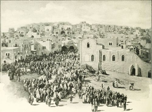 ENTRY OF PILGRIMS INTO BETHLEHEM.
CHART OF BIBLE HISTORY.
The Geography and the History of the Bible are so closely united that neither subject can be studied to advantage without the other. We therefore present at the opening of our work the Chart of Bible History, upon which the leading events of Bible History and those of the ancient world in general are arranged in parallel columns. The blue lines extending across the page represent the centuries before Christ, each space between them being 100 years. Until recently the common chronology found in all reference Bibles and Biblical works, was that prepared by Archbishop Ussher, who died in 1656, long before the present sources of information from "the monuments" had been discovered. His chronology has not been regarded as trustworthy by scholars for thirty years past; but until recently it has been retained because students of Biblical and Ancient History were not agreed as to the dates which should be given in place of it. But there is now a substantial, though not complete agreement among scholars; and we therefore discard the Ussherian system, and adopt that obtained from the information given in the inscriptions of Assyria, Babylonia, and Egypt, when compared with statements in the Bible.
We begin at the date 2500 B.C. as the events of Bible History earlier than 2500 B.C. cannot be fixed with any certainty. And it must be admitted that none of the dates earlier than 1000 B.C. can be regarded as established.
I. General Periods. In the first column we note the five great periods of Bible History. These are the natural divisions of the events contained in the Bible story.
1. The Period of the Early Races, from the Deluge, at a date unknown, to the Call of Abraham, B.C. 2280. Before the Call of Abraham, the history in the book of Genesis is introductory.
2. The Period of the Chosen Family, from the Call of Abraham, B.C. 2280, to the Exodus from Egypt, about 1250 B.C.
3. The Period of the Israelite People, from the Exodus, 1250 B.C., to the Coronation of Saul, about 1050 B.C.
4. The Period of the Israelite Kingdom, from the Coronation of Saul, 1050 B.C., to the Captivity in Babylon, B.C. 587.
5. The Period of the Jewish Province, from the Captivity in Babylon, 587 B.C., to the Destruction of Jerusalem by the Romans, A.D. 70.
II. In the second column the larger periods are broken up into Subdivisions. 1. In the Period of the Early Races the line of division is made at the Dispersion of the Races, to which no date is assigned. 2. The Period of the Chosen Family is subdivided at the Descent into Egypt by Jacob and his family, about 2060 B.C. 3. The Period of the Israelitish People has three subdivisions. (1.) The Wandering in the Wilderness, from the Exodus, B.C. 1250, to the Entrance into Canaan, B.C. 1210. (2.) The Settlement, extending to the Mesopotamian Oppression, B.C. 1180. (3.) The Rule of the Judges, to the Coronation of Saul, B.C. 1050. 4. The Period of the Israelitish Kingdom naturally divides itself into three sections. (1.) Unity, to the Division of the Kingdom, B.C. 935. (2.) Division, to the Captivity of the Ten Tribes, B.C. 721. (3.) Decay, the stage of the kingdom of Judah alone, from B.C. 721 to 587, the Babylonian Captivity. 5.The Period of the Jewish Province has five subdivisions. (1.) Chaldean Rule, to the Return from Captivity, B.C. 536. (2.) Persian Rule, to the Conquest by Alexander the Great, B.C. 330. (3.) Greek Rule, under the kingdoms of Alexander's successors to the Revolt of Mattathias, B.C. 168. (4.) Jewish Independence, to the Annexation of Judæa to the Roman Empire, A.D. 6. (5.) Roman Rule, to the final Destruction of Jerusalem, A.D. 70.
III. Next, we notice the prominent Persons and Rulers in Sacred History. The perpendicular lines opposite the names of the patriarchs indicate the duration of their lives, according to the common chronology. Only the most important of the Judges are named, and with each is given his number in the order of the list. The crowns show the kings, and the years show the period of their reigns. The chronology during the age of the Judges is very uncertain, and the dates are only conjectural.
IV. The Events of Bible History, given in the fourth column, are too numerous to be recapitulated. The student should divide them according to the Subdivisions of the Periods, already given.
V. The History of Egypt occupies the fifth column. The opinions of scholars are greatly at variance with regard to the dates of the first eighteen dynasties, some of them differing by a thousand years. The ancient history of Egypt is divided into three sections. (1.) The Old Kingdom, founded by Menes perhaps 4700 B.C., and governed by ten dynasties in succession. (2.) The Middle Kingdom, from about 2900 B.C. to 1570 B.C., Dynasties XI. to XVII. (3.) The New Kingdom, from 1570 B.C. to 525 B.C., Dynasties XVII. to XXVII. Egypt was part of the Persian Empire from 525 to 332 B.C. After 323 B.C. it was governed by a line of Greek kings, who bore the name of Ptolemy, until 30 B.C., when it became a Roman province.
VI. The Kingdoms of the East, Babylonia and Assyria, appear on the sixth column; beginning with a number of states in Babylonia; becoming an empire under Hammurabi about 2280 B.C.; by turns strong and weak until about 1100 B.C., when the Assyrian empire arose, overpowering Babylon. The Assyrian Empire lasted until 625 B.C., when Babylon again arose to power, though the Chaldean Empire did not begin until 606 B.C. In 536 B.C. it fell before the Persian conquerors, and the whole world of the Bible was under Persian control until 330 B.C., when Alexander the Great won it. No world-empire arose after the death of Alexander, until the Roman period.[14]
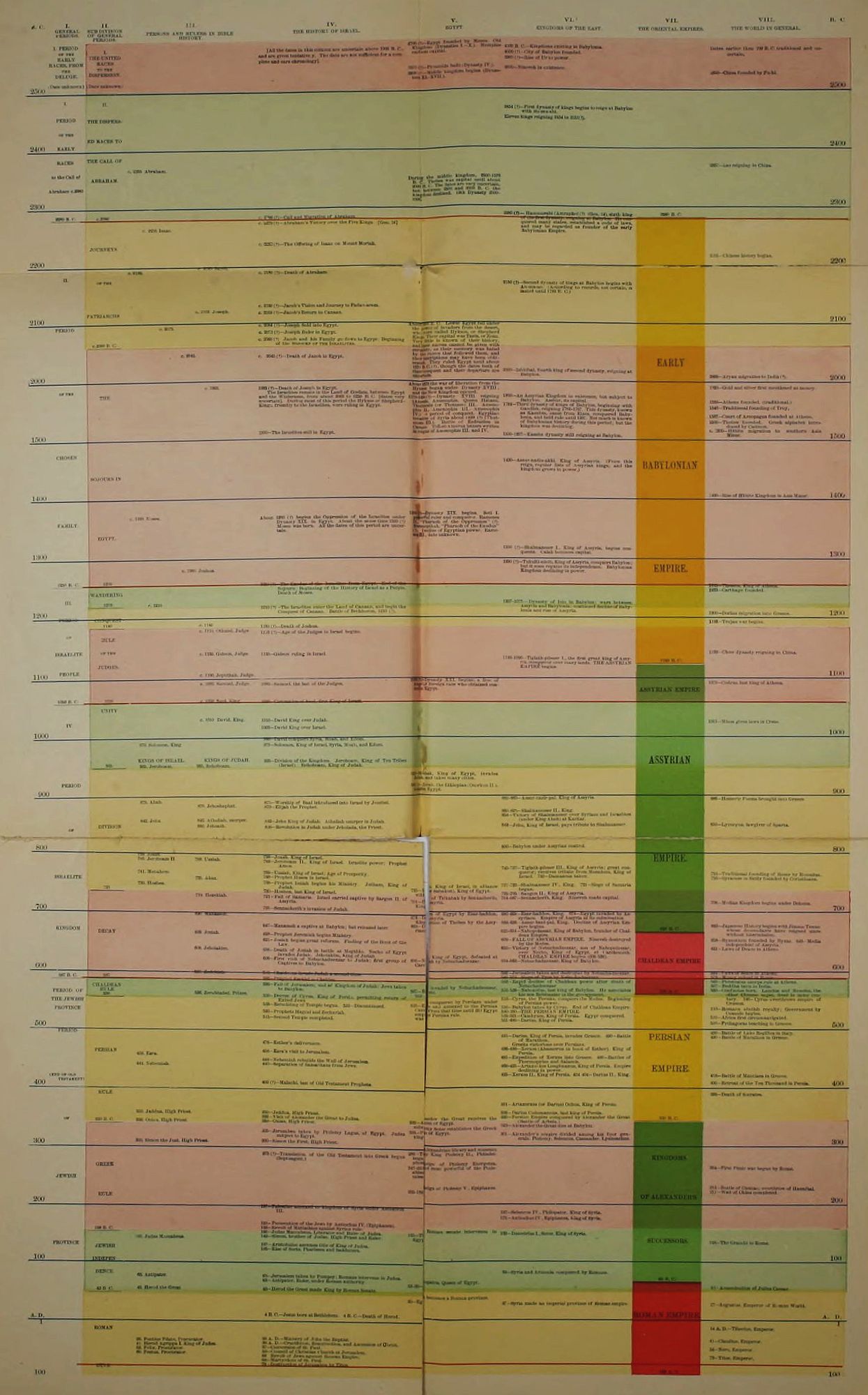
Transcriber's Note: As the color version of the Chart is mostly unreadable, black and white copies have been included below. If a line of text or paragraph is cut off, then it will appear on the following page in its entirety.
| B.C. | I. GENERAL PERIODS | II. SUB-DIVISION OF GENERAL PERIODS. | III. PERSONS AND RULERS IN BIBLE HISTORY. | IV. THE HISTORY OF ISRAEL. | V. EGYPT. | VI. KINGDOMS OF THE EAST. | VII. THE ORIENTAL EMPIRES. | VIII. THE WORLD IN GENERAL. | B.C. | ||||
| 2500 | I. PERIOD OF THE EARLY RACES, FROM THE DELUGE. | I. THE UNITED RACES TO THE DISPERSION. | [All the dates in this column are uncertain above 1000 B.C., and are given tentatively. The dates are not sufficient for a complete and sure chronology]. |
4700(?)—Egypt founded by Menes. Old Kingdom (Dynasties I.-X.). Memphis earliest capital.
3500(?)—Pyramids built (Dynasty IV.).
2900(?)—Middle kingdom begins (Dynasties XI.-XVII.)
|
4500 B.C.—Kingdoms existing in Babylonia.
4000(?)—City of Babylon founded.
3900(?)—Rise of Ur to power.
3000—Nineveh in existence.
| Dates earlier than 700 B.C. traditional and uncertain.
2850--China founded by Fu-hi.
| 2500 | ||||||
| 2400 | I. PERIOD OF THE EARLY | I. THE DISPERSED RACES TO |
2454(?)—First dynasty of kings begins to reign at Babylon with Su-mu-abi.
Eleven kings reigning 2454 to 2151(?). | 2400 | |||||||||
| 2300 | RACES to the Call of Abraham c. 2280 | THE CALL OF ABRAHAM. | c. 2355 Abraham. | During the middle kingdom, 2900-1570 B.C. Thebes was capital until about 2000 B.C. The dates are very uncertain, but between 2500 and 2000 B.C. the kingdom declined. 12th Dynasty 2500-2300. |
2357—Lao reigning in China.
| 2300 | |||||||
| 2280 B. C. | c. 2280 |
c. 2280(?)—Call and migration of Abraham.
|
2280(?)—Hammurabi
| ||||||||||
| 2200 | JOURNEYS | c. 2256 Isaac. |
c. 2270(?)—Abraham's Victory over the Five Kings. [Gen. 14]
c. 2232(?)—The Offering of Isaac on Mount Moriah.
|
(Amraphel(?)) 2280 B.C. (Gen. 14), sixth king of the first dynasty reigning at Babylon. He conquered many states, established a code of laws, and may be regarded as founder of the early Babylonian Empire.
| 2205—Chinese history begins. | 2200 | |||||||
| 2100 | II. | OF THE PATRIARCHS | c. 2195 Jacob. c. 2180 c. 2103 Joseph. | c. 2180(?) Death of Abraham. c. 2120(?)—Jacob's Vision and Journey to Padan-aram. c. 2103(?)—Jacob's Return to Canaan. | 2150(?)—Second dynasty of kings at Babylon begins with An-ma-an. (According to records, not certain, it lasted until 1783 B.C.) | 2100 | |||||||
| PERIOD | c. 2060 B. C. | c. 2075. | c. 2084(?)—Joseph Sold into Egypt. c. 2073(?)—Joseph Ruler in Egypt. c. 2060 B.C. c. 2060(?)—Jacob and his Family go down to Egypt; Beginning of the Sojourn of the Israelites. | About 2000 B.C. Lower Egypt fell under the power of invaders from the desert, who were called Hyksos, or Shepherd Kings. Their capital was Tanis, or Zoan. Very little is known of their history, and their names cannot be given | |||||||||
| 2000 | c. 2045. |
c. 2045(?)—Death of Jacob in Egypt.
| with certainty, as their memory was hated by the rulers that followed them, and their inscriptions may have been obliterated. They ruled Egypt until about 1570 B.C.(?), though the dates both of their conquest and their departure are uncertain. | 2000—Ishkibal, fourth king of second dynasty, reigning at Babylon. | EARLY | 2000—Aryan migration to India(?). | 2000 | ||||||
| 1500 | OF THE | THE | c. 1993. |
1993(?)—Death of Joseph in Egypt The Israelites remain in the Land of Goshen, between Egypt and the Wilderness, from about 2062 to 1250 B.C. [dates very very uncertain]. During most of this period the Hyksos or Shepherd-Kings, friendly to the Israelites, were ruling in Egypt.
1500—The Israelites still in Egypt.
|
About 1570 the war of liberation from the Hyksos began under Dynasty XVIII., and the New Kingdom opened.
1570-1320(?)—Dynasty XVIII. reigning (Amosis, Amenophis, Queen Hatasu, Thutmosis (Thotmes) III., Amenophis II., Amenophis III., Amenophis IV.). A period of conquest. Egyptian invasion of Syria about 1490(?) (Thutmosis III.). Battle of Esdraelon in Canaan. Tell-el-Amarna letters written in reigns of Amenophis III. and IV.
|
1800—An Assyrian Kingdom in existence, but subject to Babylon. Asshur, or its capital.
1782—Third dynasty of kings of Babylon, beginning with Gandish, reigning 1782-1767. This dynasty, known as Kassites, came from Elam, conquered Babylonia, and held rule until 1207. Not much is known of Babylonian history during this period; but the kingdom was declining.
1500-1207—Kassite dynasty still reigning at Babylon.
| 1920—Gold and silver first mentioned as money. 1556—Athens founded. (traditional.) 1546—Traditional founding of Troy. 1507—Court of Areopagus founded at Athens. 1500—Thebes founded. Greek alphabet introduced by Cadmus. c. 1500—Hittite migration to southern Asia Minor. | 1500 | |||||
| 1400 | CHOSEN | SOJOURN IN |
1430—Assur-nadin-akhi. King of Assyria. (From this reign, regular lists of Assyrian kings; and their kingdom grows in power.)
| BABY-LONIAN |
1400—Rise of Hittite Kingdom in Asia Minor.
| 1400 | |||||||
| 1300 | FAMILY | EGYPT. | c. 1330 Moses. |
About 1330(?) begins the Oppression of the Israelites under Dynasty XIX. in Egypt. About the same time 1330 (?) Moses was born. All the dates of this period are uncertain.
|
1359(?)—Dynasty XIX. begins. Seti I. powerful ruler and conqueror. Rameses II., "Pharaoh of the Oppression" (?). Merenepthah, "Pharaoh of the Exodus" (?). Decline of Egyptian power. Rameses III., date unknown.
|
1300(?)—Shalmaneser I., King of Assyria, begins conquests. Calah becomes capital.
| 1300 | ||||||
| 1250 B. C. | 1250 | c. 1260 Joshua. |
1250(?)—The Exodus of the Israelites from Egypt. End of the
|
1290(?)—Tukulti-ninib, King of Assyria, conquers Babylon; but it soon regains its independence. Babylonian Kingdom declining in power.
| EMPIRE. | ||||||||
| III. | WANDERING 1210 | c. 1210 |
Sojourn; Beginning of the History of Israel as a People. Death of Moses.
|
1207-1075—Dynasty of Isin in Babylon;
|
1235—Theseus, King of Athens.
1233—Carthage founded.
| ||||||||
| 1200 | PERIOD | CONQUEST |
1210(?)—The Israelites enter the Land of Canaan, and begin the Conquest of Canaan. Battle of Beth-horon, 1210(?).
|
wars between Assyria and Babylonia; continued decline of Babylonia and rise of Assyria.
| 1200 | ||||||||
| 1180 | c. 1180 |
1180(?)—Death of Joshua.
|
1193—Trojan war begins.
| ||||||||||
OF ISRAELITE | RULE OF THE |
c. p1170. Othniel, Judge.
c. 1130. Gideon, Judge.
|
1170(?)—Age of the Judges in Israel begins.
1130—Gideon ruling in Israel.
|
1120-1090—Tiglath-pileser I., the first great king of Assyria,
| 1120 B. C. |
1122—Chow dynasty reigning in China.
| |||||||
| 1100 | PEOPLE | JUDGES |
c. 1100. Jephthah, Judge.
|
conqueror over many lands. THE ASSYRIAN EMPIRE begins.
| 1100 | ||||||||
| 1050 B. C. | 1050 |
c. 1080—Samuel, Judge.
c. 1050. Saul, King.
|
1080—Samuel, the last of the Judges.
1050—Coronation of Saul, King of Israel.
|
1089(?)—Dynasty XXI. begins; a line of kings of foreign race who obtained control in Egypt.
|
1070—Codrus; last king of Athens.
| ||||||||
| 1000 | IV. | UNITY | c. 1010 David |
1010—David King over Judah.
1003—David King over Israel.
|
1015—Minos gives laws in Crete.
| 1000 | |||||||
| 935 | 970. Solomon, King.
|
990—David conquers Syria, Moab, and Edom.
970—Solomon, King of Israel, Syria, Moab, and Edom.
935—Division of the Kingdom. Jeroboam, King of Ten Tribes (Israel). Rehoboam, King of Judah.
| ASSYRIAN | ||||||||||
| 900 | PERIOD |
925—Shishak, King of Egypt, invades Judah, and takes many cities.
900(?)—Zerah, the Ethiopian (Osorkon II.), invades Egypt.
| 900 | ||||||||||
| 800 | OF | DIVISION |
|
875—Worship of Baal Introduced into Israel by Jezebel.
870—Elijah the Prophet.
842—Jehu King of Judah. Athaliah usurper in Judah.
836—Revolution in Judah under Jehoiada, the Priest.
|
885-860—Assur-nazir-pal, King of Assyria.
854—Victory of Shalmaneser over Syrians and Israelites (under King Ahab) at Karkar.
842—Jehu, King of Israel, pays tribute to Shalmaneser.
|
886—Homeric Poems brought into Greece.
850—Lycurgus, lawgiver of Sparta.
| 800 | ||||||
| ISRAELITE | 721 |
|
799—Joash, King of Israel.
783—Jeroboam II., King of Israel. Israelite power; Prophet Amos.
769—Uzziah, King of Israel; Age of Prosperity.
748—Prophet Hosea in Israel.
738—Prophet Isaiah begins his Ministry. Jotham, King of Judah.
730. Hoshea. (Isr.)
|
725—Hoshea, King of Israel, in Alliance with So (or Sabakon), King of Egypt.
|
45-727—Tiglath-pileser III., King of Assyria; great conqueror; receives tribute from Menahem, King of Israel. 732—Damascus taken.
827-722—Shalmaneser IV., King. 725—Siege of Samaria begun.
| EMPIRE. |
886—Homeric Poems brought into Greece.
753—Traditional founding of Rome by Romulus.
750—Syracuse in Sicily founded by Corinthians.
| ||||||
| 700 | 719. Hezekiah. (Jud.) |
721—Fall of Samaria. Israel carried captive by Sargon II. of Assyria.
701—Sennacherib's invasion of Judah.
|
701—Defeat of Tirkahah by Sennacherib, King of Assyria.
|
704-687—Sennacherib, King. Nineveh made capital.
|
708—Median Kingdom begins under Deioces.
| 700 | |||||||
| KINGDOM | DECAY | 690. Manasseh. (Jud.) 639. Josiah. (Jud.) |
647—Manasseh a captive at Babylon; but released later.
628—Prophet Jeremiah begins Ministry.
|
674—Invasion of Egypt by Esar-haddon, King of Assyria.
665—Destruction of Thebes by the Assyrians.
|
680-668—Esar-haddon, King. 674—Egypt invaded by Assyrians. Empire of Assyria at its culmination.
668-626—Assur-bani-pal, King. Decline of Assyrian Empire begins.
| 626 B. C. |
660—Japanese History begins with Jimmu Tenno whose descendants have reigned since without intermission.
| ||||||
| 600 | 608. Jehoiakim. (Jud.) |
621—Josiah begins great reforms. Finding of the Book of the Law.
608—Death of Josiah in battle at Megiddo. Necho of Egypt invades Judah. Jehoiakim, King of Judah.
606—First visit of Nebuchadnezzar to Judah; first group of Captives to Babylon.
|
606—Necho, King of Egypt, defeated at Carchemish by Nebuchadnezzar.
|
625-604—Nabopolassar, King of Babylon, founder of Chaldean Empire.
609—FALL OF ASSYRIAN EMPIRE. Nineveh destroyed by the Medes.
608—Victory of Nebuchadnezzar, son of Nabopolassar, over Necho, King of Egypt, at Carchemish. CHALDEAN EMPIRE begins (606-536).
604-562—Nebuchadnezzar, King of Babylon.
| CHALDEAN EMPIRE |
658—Byzantium founded by Byzas. 640—Media independent of Assyria.
621—Laws of Draco in Athens.
| 600 | ||||||
| 587 B. C. | 587 | 597. Zedekiah. |
598—Chaldeans invade Judah a second time.
592—Prophet Ezekiel in Chaldea.
|
586—Jerusalem taken and destroyed by Nebuchadnezzar.
585-573—Siege of Tyre by Nebuchadnezzar.
|
593—Laws of Solon in Athens.
578—Money coined in Rome.
| ||||||||
| PERIOD OF | CHALDEAN RULE 536 | 936. Zerubbabel, Prince. |
586—Fall of Jerusalem; end of Kingdom of Judah; Jews taken to Babylon
536—Decree of Cyrus, King of Persia,
|
567—Egypt invaded by Nebuchadnezzar, but not held.
|
562—Rapid decline of Chaldean power after death of Nebuchadnezzar.
558-536—Nabonidus, last king of Babylon. He associates his son Belshazzar in the government.
| 536 B. C. |
560—Pisistratus usurps rule at Athens.
557—Buddha born in India.
550—Confucius born. Laocius and Mencius,
| ||||||
| 500 | THE JEWISH PROVINCE |
permitting return of Exiled Jews.
535—Rebuilding of Temple begun. 522—Discontinued.
520—Prophets Haggai and Zechariah.
515—Second Temple completed.
|
525—Egypt conquered by Persians under Cambyses and annexed to the Persian empire. From that time until 332 Egypt was under Persian rule.
|
553—Cyrus, the Persian, conquers the Medes. Beginning of Persian power.
536—Babylon taken by Cyrus. End of Chaldean Empire.
530-330—THE PERSIAN EMPIRE.
529-521—Cambyses, King of Persia. Egypt conquered.
521-486—Darius, King of Persia.
|
the other Chinese sages, lived in same century. 546—Cyrus overthrows empire of Crœsus.
510—Romans abolish royalty; Government by Consuls begins.
510—Africa first circumnavigated.
500—Pythagoras teaching in Greece.
| 500 | |||||||
| 400 | PERIOD (END OF OLD TESTAMENT) | PERSIAN | 458. Ezra. 444. Nehemiah. |
478—Esther's deliverance.
458—Ezra's visit to Jerusalem.
444—Nehemiah rebuilds the Wall of Jerusalem.
440—Separation of Samaritans from Jews.
400(?)—Malachi, last of Old Testament Prophets.
|
491—Darius, King of Persia, invades Greece. 490—Battle of Marathon. Greeks victorious over Persians.
486-466—Xerxes (Ahasuerus in book of Esther), King of Persia.
481—Expedition of Xerxes into Greece.
466-425—Artaxerxes Longimanus, King of Persia. Empire declining in power.
425—Xerxes II., King of Persia.
| PERSIAN EMPIRE. |
490—Battle of Lake Regillus in Italy.
490—Battle of Marathon in Greece.
418—Battle of Mantinea in Greece.
400—Retreat of the Ten Thousand in Persia.
| 400 | |||||
| OF | 330 B. C. | 350. Jaddua, High Priest. 330. Onias, High Priest. |
350—Jaddua, High Priest.
332—Visit of Alexander the Great to Judea.
330—Onias, High Priest.
|
332—Alexander the Great receives the submission of Egypt.
|
361—Artaxerxes (or Darius) Ochus, King of Persia.
336—Darius Codomannus, last king of Persia.
330—Persian Empire conquered by Alexander the Great (Battle of Arbela.)
| 330 B. C. |
399—Death of Socrates.
| ||||||
| 300 |
300. Simon the Just, High Priest.
|
305—Jerusalem taken by Ptolemy Lagus, of Egypt. Judea subject to Egypt.
300. Simon the Just, High Priest.
|
328—Ptolemy Soter establishes the Greek kingdom of Egypt.
|
323—Alexander the Great dies at Babylon.
301—Alexander's empire divided among his four generals Ptolemy, Seleucus, Cassander, Lysimachus.
| 300 | ||||||||
| 200 | JEWISH | GREEK RULE |
275(?)—Translation of the Old Testament into Greek begun (Septuagint.)
|
286—The Alexandrian library and Museum began by King Ptolemy II., Philadelphus.
247-225—Reign of Ptolemy Euergetes, ablest and most powerful of the Ptolemies.
205-182—Reign of Ptolemy V. Epiphanes.
| KINGDOMS OF ALEXANDER'S |
264—First Punic war begun by Rome.
216—Battle of Cannae; overthrow of Hannibal.
211—Wall of China completed.
| 200 | ||||||
| 168 B. C. |
197—Palestine annexed to kingdom of Syria under Antiochus III.
168—Persecution of the Jews by Antiochus IV. (Epiphanes).
168—Revolt of Mattathias against Syrian rule.
|
187—Seleucus IV., Philopator, King of Syria.
175—Antiochus IV., Epiphanes, King of Syria.
| |||||||||||
| 100 | PROVINCE | JEWISH INDEPENDENCE |
166. Judas Maccabeus
|
166—Judas Maccabeus, Liberator and Ruler of Judea.
107—Aristobulus assumes title of King of Judea.
105—Rise of Sects, Pharisees and Sadducees.
|
165—The Roman senate intervenes in Egypt.
|
162—Demetrius I., Soter, King of Syria.
| SUCCESSORS. |
123—The Gracchi in Rome.
| 100 | ||||
63. Antipater.
|
63—Jerusalem taken by Pompey; Romans intervene in Judea.
63—Antipater, Ruler, under Roman authority.
|
69—Syria and Armenia conquered by Romans.
| 60 B. C. | ||||||||||
| 43 B. C. |
43. Herod, the Great.
|
43—Herod the Great made King by Roman Senate.
|
52-30—Cleopatra, Queen of Egypt.
|
41—Assassination of Julius Caesar.
| |||||||||
| A. D. | 458. Ezra. 444. Nehemiah. |
4 B.C.—Jesus born at Bethlehem. 4 B.C.—Death of Herod.
|
30—Egypt becomes a Roman province.
|
27—Syria made an imperial province of Roman empire.
| ROMAN |
27—Augustus, Emperor of Roman World.
| A. D. | ||||||
| 1 | ROMAN |
26. Pontius Pilate, Procurator.
41. Herod Agrippa I. King of Judea.
52. Felix, Procurator.
60. Festus, Procurator.
|
26—Ministry of John the Baptist.
30—Crucifixion, Resurrection, and Ascension of Christ.
37—Conversion of St. Paul.
50—Council of Christian Church at Jerusalem.
68—Revolt of Jews against Roman Empire.
68—Martyrdom of St. Paul.
70—Destruction of Jerusalem by Titus.
| EMPIRE. |
14—Tiberius, Emperor.
41—Claudius, Emperor.
54—Nero, Emperor.
79—Titus, Emperor.
| A. D. | |||||||
| 100 | RULE | 100 A. D. | 100 |
VII. The Oriental Empires are indicated upon the seventh column of the chart. While they follow in regular succession, there were brief periods of anarchy and confusion between them, which cannot be indicated. (1.) The Early Babylonian Empire, 2280-1120 B.C. Much of the time this was not an empire, but rather the leading state in the oriental world. (2.) The Assyrian Empire, 1120-626 B.C.; its capital at Nineveh on the Tigris River, its people fierce warriors, but not able rulers. (3.) The Chaldean Empire, 606-536 B.C., established by Nebuchadnezzar, and passing away soon after his death. (4.) The Persian Empire, 536-330, founded by Cyrus, and ruling over all the Old Testament lands. (5.) The Kingdoms (not empire) of Alexander's Successors, 330-60 B.C. The empire of Alexander the Great lasted only seven years (330-323), and was followed by war until 301, when the four generals of Alexander made a division of his conquests. (6.) The Roman Empire became dominant in the east about 60 B.C., and continued supreme until after the New Testament period.
VIII. The World in General. We arrange on the last column events showing the general progress of the world outside of the Bible lands. The student will note that Bible History antedates the annals of Greece and Rome by many centuries.
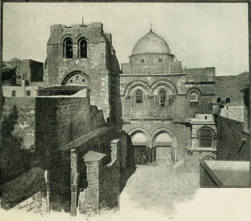 THE CHURCH OF THE HOLY SEPULCHRE.
THE OLD TESTAMENT WORLD.
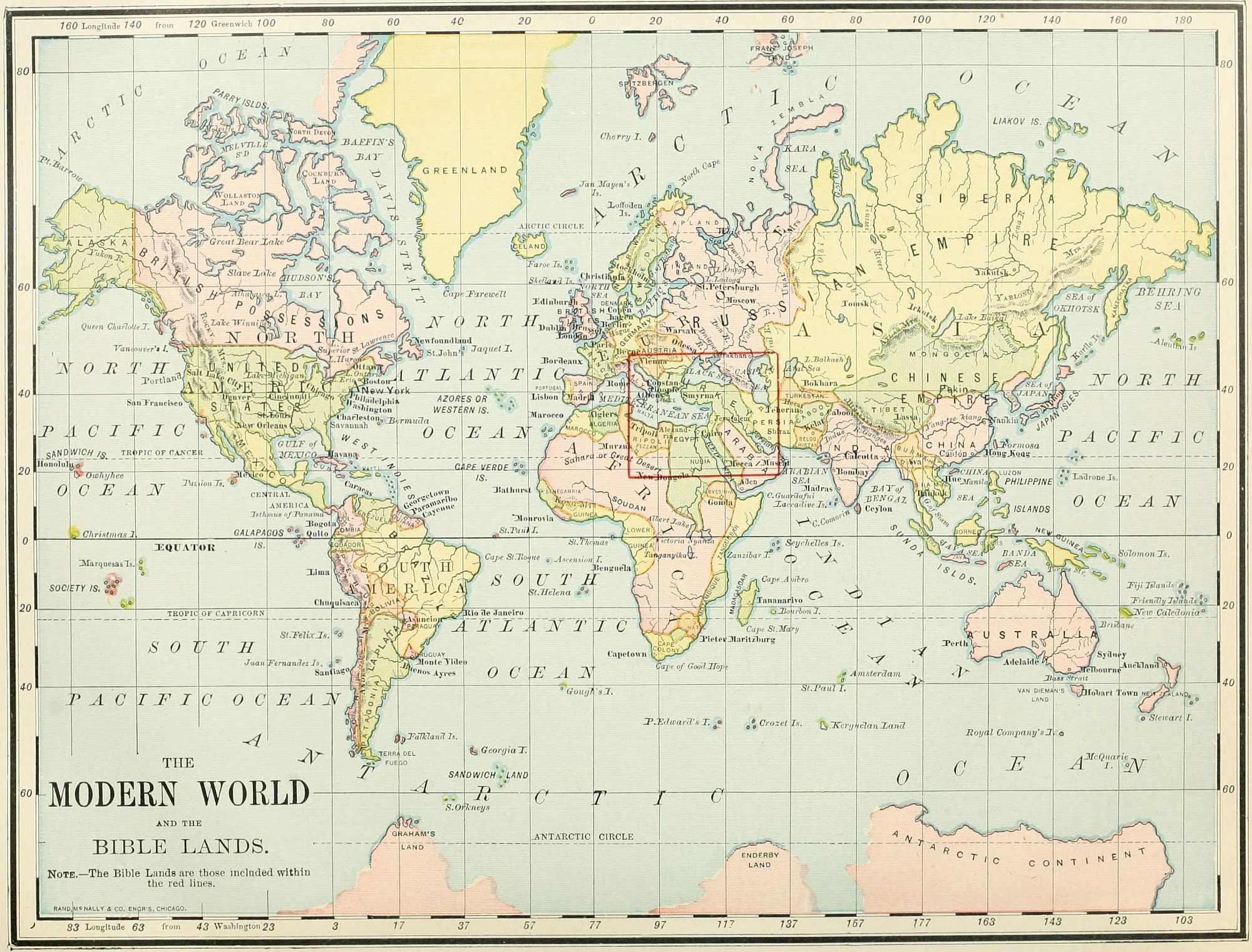
I. Extent. The Old Testament World embraces the seas and lands between 30° and 54° east longitude, or from the mouth of the Nile to that of the Persian Gulf; and between 27° and 40° north latitude, from the parallel south of Mount Sinai to that north of Mount Ararat. The total extent of territory is about 1,400 miles from east to west and 900 miles from north to south, aggregating 1,260,000 square miles. Deducting from this the space occupied by the Mediterranean Sea and other large bodies of water, the land will include about 1,110,000 square miles, or one-third the extent of the United States, excluding Alaska. Unlike the United States, however, nearly two-thirds of this extent is a vast desert, and uninhabitable, so that the portion actually occupied by man is less than an eighth of that included in the American Union.
 Approximate Scale, 909 miles to 1 inch. COMPARATIVE VIEW OF UNITED STATES AND OLD TESTAMENT WORLD.
II. Seas. This world of the Old Testament embraces several large bodies of water. 1. The Caspian Sea, the largest body of water surrounded by land on the globe, occupies its northeastern corner. 2. The Persian Gulf, the outlet of the great rivers of the Old Testament history, is in its southeastern border. 3. The two arms of the northern end of the Red Sea, the Gulf of Suez and the Gulf of Akaba, are on its southwestern side. 4. TheMediterranean Sea, "the great sea toward the going down of the sun" (Josh. 1:4), forms a part of its western boundary. These are its largest seas; but besides these may be named three others, all salt lakes, imbedded in its mountain system. 5. The Dead Sea, called in the Bible "Sea of the Plain," and "Salt Sea," lying 1,290 feet below the Mediterranean, and situated in the land of Palestine; 6. Lake Van, anciently Arsissa, in Armenia; and 7. Lake Urumiyeh, in Media. Neither of the last two are referred to in the Bible.
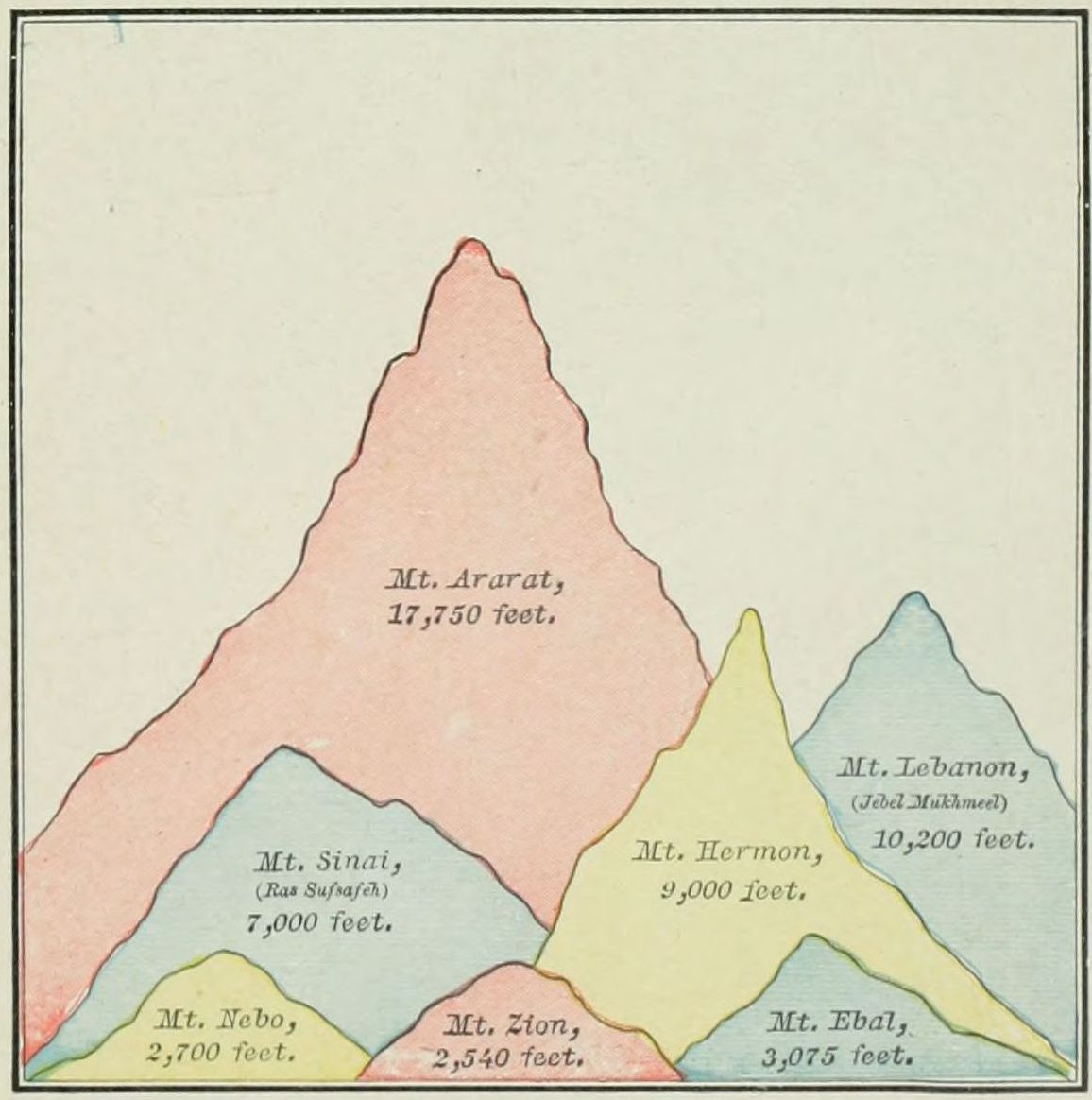 COMPARATIVE HEIGHT OF BIBLE MOUNTAINS.
III. Mountain Ranges. The nucleus of the mountain system is found in the land of Armenia, on the north of the map. Here five great ranges of mountains have their origin. 1. The Ararat Mountains are lofty masses, lying between the Caspian Sea and Asia Minor. They are arranged in three sections, nearly parallel: Mount Masius, on the south; Mount Niphates, north of Lake Van; and Mount Abus, still farther north. One of the peaks of this latter section is the traditional resting place of the ark (Gen. 8:4), and is the summit of the group, 17,750 feet high. 2. The Caspian Mountains, branching from Ararat, bend around the southern end of the Caspian Sea and extend eastward, forming the northern boundary of Media. 3. The Zagros Mountains also start from Ararat, and follow a direction generally southeast, to the northern shore of the Persian Gulf. They form the eastern watershed of the Tigris and Euphrates rivers. 4. The Lebanon Range starts from the western side of the Ararat group, and follows the Mediterranean coast through Syria and Palestine, then down the Sinaitic peninsula. Its general direction is west of south. In Syria and Palestine it is divided into two parallel branches, Lebanon and Anti-Lebanon, the latter on the east. Its highest peak is Mount Hermon, about 9,000 feet above the sea. South of Palestine it forms the remarkable Sinaitic group of mountains, upon one of which the Law was given. 5. The last range is Mount Taurus, which also branches from Ararat, in a westerly direction, and forms the southern coast line of Asia Minor.
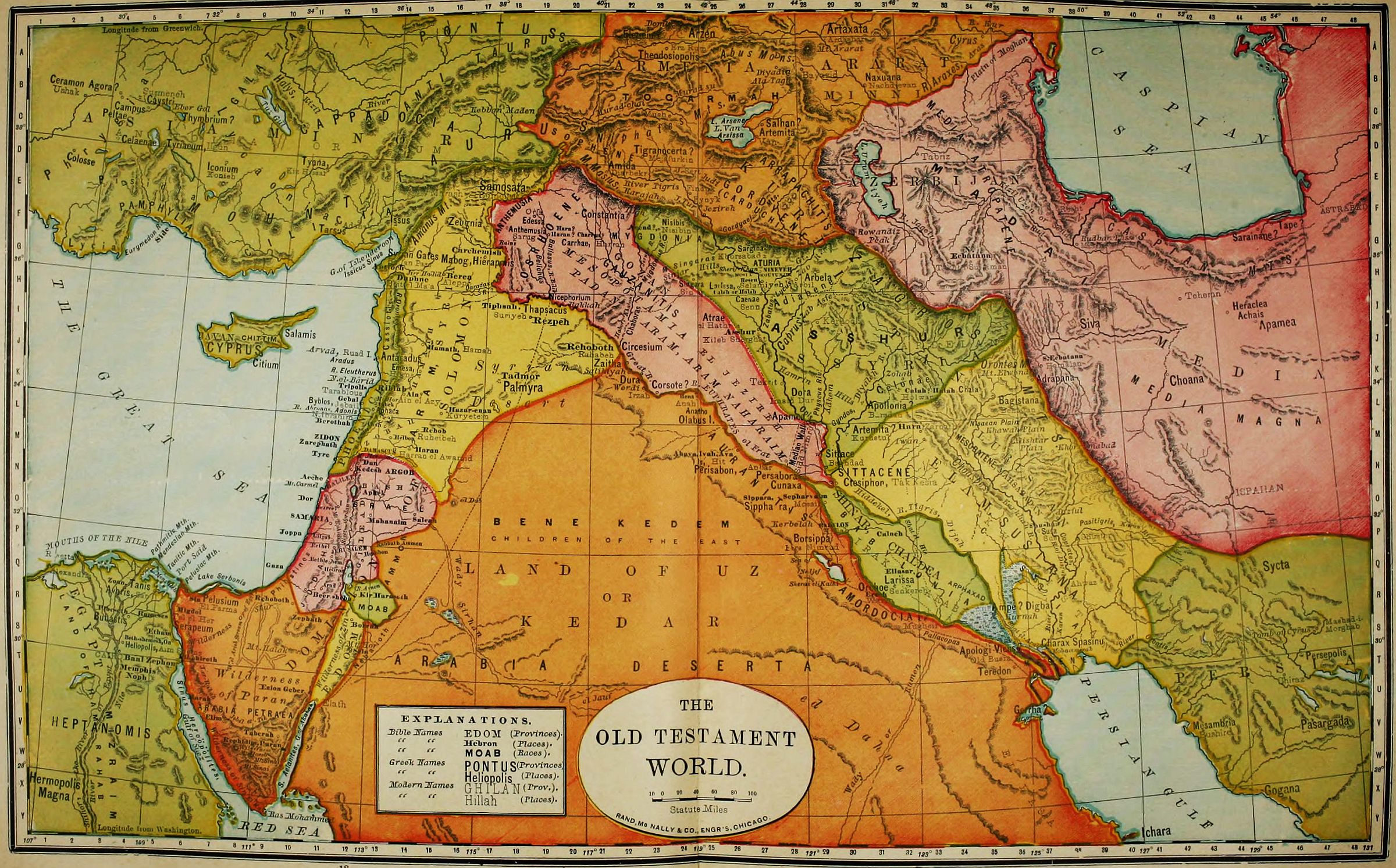
IV. Rivers. Passing by many unimportant streams, we notice the following, the largest of which have their[20] rise in the mountain system of Armenia. 1. The Araxes, not named in the Bible, but important as a boundary, rises in the northern section of the Ararat Range, and flows, in a general direction, eastward into the Caspian Sea. 2. The Tigris, called in the Bible Hiddekel, rises in Mount Niphates, of the Ararat Range, and flows in a southeasterly direction, following the line of Mount Zagros, unites with the Euphrates, and thence flows into the Persian Gulf. Its length to the union with the Euphrates is 1,146 miles; beyond the union to the gulf, at present, 100 miles, though anciently much less; and at a time within the limits of history the two rivers discharged by separate mouths. Their united stream is now called the Shaat el Arab. 3. The Euphrates, or the Frat (a word meaning "abounding"), is the great river of the Bible world. It has two important sources, both in Armenia: one at a place called Domli; the other, the more distant and true source, at Diyadin, at the foot of a mountain called Ala Tagh, 20 miles west of Mount Ararat. It flows westward 400 miles, then southward about as far, then in a southeasterly direction 1,000 miles, uniting at last with the Tigris to form the Shaat el Arab. It is navigable for 1,100 miles, and has in all ages formed the principal means of travel between Eastern and Western Asia. At Babylon, it is nearly a mile in width, though for 800 miles it does not receive a single tributary, as it flows through a desert. It overflows its banks every year, rising as high as twelve feet. 4. The Orontes rises in Mount Lebanon, and flows northward parallel with the Mediterranean until, just before reaching Asia Minor, it breaks through the mountains and empties into the sea. 5. The Jordan, least yet most important of all, flows southward from the foot of Mount Hermon into the Dead Sea. It will be described in connection with the Physical Map of Palestine. 6. The Nile, the great river of Africa, rises in the centre of the continent and flows northward into the Mediterranean Sea, turning the desert through which it passes into a garden.
V. The Lands. These are not easy to determine since their boundaries and names varied at different periods of the history. Yet their locations may be given, and their natural limits are generally known. They may be classified as follows: 1. Lands of the Mountain System, all north and east of the Zagros chain of mountains: Armenia, Media, and Persia. 2. Lands of the Plain: Assyria, Elam, Mesopotamia, Chaldea, Arabia. 3. Lands of the Mediterranean: Asia Minor, Syria, Phœnicia, Palestine, The Wilderness, Egypt.
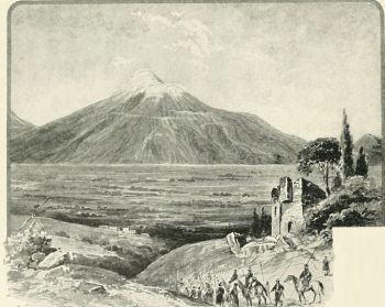 MOUNT ARARAT.
I. LANDS OF THE MOUNTAIN SYSTEM.
1. Armenia is a name nowhere used in the original Scriptures, but in our version is a translation of the word "Ararat," which word properly appears in place of "Armenia" in the Revised Version. The province embraces the lofty plateau and mountain group between the Caspian and Black Seas, and north of Mesopotamia and Assyria, the source of four great rivers, the Araxes, Tigris, Euphrates, and Acampsis, the latter pouring into the Black Sea. Its boundaries are: upon the north, the Caucasus Mountains; on the east, Media and the Caspian Sea; on the south, Media, from which it is separated by the Araxes, and Assyria, from which it is divided by Mount Masius; and on the west, the Euphrates, separating it from Asia Minor. Tradition states that it was settled by Haïk, a grandson of Japhet; and the earliest history names it as tributary to Assyria. Excepting the resting of Noah's ark upon one of its mountains, few events of Scripture are associated with it.
2. Media is in the original the same word as Madai, the son of Japhet. (Gen. 10:2.) Its boundaries are the river Araxes and the Caspian Sea on the north, the great salt desert of Iram on the east, Persia on the south, and the Zagros Mountains, separating it from Assyria and Armenia. A branch of the Zagros Mountains, running eastward, divides it into two portions, anciently known as Media Atropatene (the one northward) and Media Magna. In each of these provinces the principal city was called Ecbatana. The Medes were of the Aryan or Japhetic stock, and were always a warlike and independent people. Though conquered by Assyria, their land was never formally annexed to the Assyrian empire. In[21] B.C. 633 the Median kingdom was established, and soon became supreme over Assyria, Armenia, and Persia, and formed the Medo-Persian empire, which succeeded to the power of Babylon in the East, B.C. 536. After that date the history of Media is lost in that of Persia.
3. Persia was originally a small province on the Persian Gulf, still known as Fars. But Persia Proper included, besides the sandy plain on the gulf, a mountainous plateau north of it, and was bounded by Media on the north, by Carmania on the east, by the Persian Gulf on the south, and by Elam on the west. Its people were of the Aryan race, and at first subject to the Medes. They revolted under Cyrus the Great, and became the controlling power in the conquest of Nebuchadnezzar's dominion. The Persian empire arose to greatness at the fall of Babylon, B.C. 536, conquered and ruled over all the lands from India to Ethiopia, and was by far the greatest of the great Oriental monarchies. It was subjected by Alexander the Great, B.C. 330. The capital of the Persian empire was Susa, called in the Bible "Shushan the Palace" (Esther 1:2); which was, however, situated not in Persia Proper, but in Elam. The most important places in the province were Persepolis (its capital at one period), Pasargada, and Mesambria, none of which are named in the Bible.
II. LANDS OF THE PLAIN.
Of these, two are situated mainly between the Zagros chain of mountains and the Tigris river, Assyria and Elam; two are between the Tigris and Euphrates, Mesopotamia and Chaldea; and one is the vast Arabian desert.
1. Assyria, in the Hebrew everywhere Asshur, was properly the province now called Kurdistan, lying on the western slope of the Zagros Mountains, and extending across the Tigris to the Sinjar hills and the border of the Mesopotamian desert. The mountains separate it from Armenia; and the line of division from Elam, on the southeast, was near the place where the Tigris and Euphrates approach nearest before their separation. The land was occupied by people of various races, of which the Semitic were predominant. The earliest city was at Asshur, supposed to be Kileh Sherghat, where a dynasty of kings began to rule about 1800 B.C., while the Israelite tribes were in Egypt. The seat of government was afterward transferred to Calah, or Halah (Nimrud), north of Asshur; and finally a permanent location of the capital was made at Nineveh, which became the centre of the great Assyrian empire. This will be described more fully with the map of that empire, on page 91. The Assyrian kingdom was long in its duration, but passed through many vicissitudes, several times ruling all the lands of the Euphrates, and again, in a feeble condition. Its principal cities, besides Nineveh, were Calah, Resen (which may have been at Selamiyeh, three miles south of Nineveh), and Rehoboth. There is reason to believe that all the four cities named in Gen. 10:11, 12, were combined in the walls of Nineveh.
2. Elam, called Susiana by the Greeks, lay southeast of Assyria and west of Persia Proper, between the Zagros chain of mountains and the Tigris river. It included both a mountainous and a lowland tract, the latter very fertile. Shushan (Susa), the capital of the Persian empire, lay within this province, and was its principal city. The earliest conqueror named in the Bible, Amraphel, was the king of Elam, and held dominion over most of the lands as far west as Canaan. (See the map of his empire, on page 34.) This kingdom was not of long continuance as an independent state, but soon fell under the power of Assyria, though maintaining its own organization as a vassal state until the Persian period, when it became a province of the empire.
3. Mesopotamia, called in Scripture Aram-naharaim, or "Syria of the two rivers," was a land of indefinite boundaries. The name means "between the rivers," and hence it was often applied to all the plain between the Tigris and Euphrates, including even Chaldea and a part of Assyria. A more frequent use of the name restricts it to the northwestern portion of the region between the rivers, above the place where they approach and separate again. The Sinjar hills, crossing, divide it into two sections, a higher and a lower, the former mountainous, and the latter mostly a great desert. The upper section contained the cities of Orfa (Edessa), formerly supposed to be the birthplace of Abraham; Haran, the patriarch's resting place on the way to Canaan; Nisibis and Amida, now Nisibin and Diarbekr. The only time when Mesopotamia appears in Bible history as a kingdom was a brief interval during the period of the Judges. (Judg. 3:8.) Earlier it had been occupied by separate and warring tribes; later it was a part of Assyria.
4. Chaldea is also called Shinar and Babylonia. The name Chaldea, in its most accurate sense, belongs to the southern portion of the province, but is generally used with reference to all the Mesopotamian plain south of Baghdad. It is perfectly level, and by nature one of the most fertile places on the whole earth. Its earliest inhabitants, at least the ruling portion of them, were Cushites, of the stock of Ham. An early Oriental kingdom began at Ur (Mugheir) about B.C. 3900. It lasted, with varying fortunes, until B.C. 538. Babylon afterward became the capital, and in a later period was the greatest city of the East. (See diagram on page 93.) Other cities of Chaldea were Erech (Orchoë), Calneh, and Sepharvaim. Further details of its political history are given in the account of the Babylonian empire of Nebuchadnezzar, on page 92.
5. The desert of Arabia occupies more than half of the map of the Old Testament World. That portion of it included upon the map is a vast triangle, having for its base the 28th parallel of latitude, from the Persian Gulf to the Red Sea, the Euphrates on its northeastern side, and the border of the Lebanon chain of mountains for its western. It is called in the Bible "the land of Kedar." It is a high, undulating, dry plain, with few oases, and almost impenetrable to travelers. From the[22] days of Abraham until the present, the caravans have gone around it upon the north, following up the Euphrates to Tiphsah (Thapsacus), and then turning southward rather than face its terrors. Only once in history is it related that an army crossed it. This was when Nebuchadnezzar, while ravaging Palestine, learned of his father's death, and crossed this great desert by the most direct route, in order to take possession of the throne.
III. LANDS OF THE MEDITERRANEAN.
These lands will receive more extended treatment in connection with other maps, so that we give them only a brief mention here.
1. Asia Minor scarcely enters the field of the Old Testament, except as the "land of the Hittites." It will be noticed under the topic of the Journeys of the Apostle Paul, page 117.
2. Syria, in the Hebrew Aram, is a name of indefinite signification, sometimes embracing all the territory north of The Wilderness of the Wandering, and therefore including Palestine and the provinces around it. But Syria Proper seems only to indicate the territory bounded by the Amanus and Taurus ranges of mountains on the north, by the Euphrates and the desert on the east, by Palestine, beginning with Mount Hermon, on the south, by the Mediterranean and Phœnicia on the west. It reaches the Mediterranean only near the mouth of the Orontes. It consists of three portions: On the north an elevated tract, never thickly populated, having Carchemish and Samosata as its principal cities; between the Lebanon and Anti-Lebanon ranges of mountains a great valley, called Cœle-Syria, "hollow Syria," forming the bed of the Orontes, flowing north, and the Leontes (Litany), flowing south; and on the east a level country reaching to the desert, containing the cities of Damascus on the south, Tiphsah (Thapsacus) on the north, and Tadmor (Palmyra) in the desert. During the times from Jeroboam to Jehoash, Syria was an independent kingdom, the rival of Israel, with which its political relations may be seen on the map on page 86. In the Old Testament period, Damascus was its principal city, and exercised sovereignty; but later, Antioch, in the north, became more prominent, and was the Greek and Roman capital of the province.
3. Phœnicia is a narrow strip of territory between the Mediterranean Sea and Mount Lebanon, north of Palestine and south of the Orontes. Its two great cities were, Zidon, the mother of Mediterranean commerce; and Tyre, her daughter. Its boundaries were never extensive; but its vessels traded with every land, and its colonies were planted all along the shores of the Mediterranean.
4. Palestine lies south of Phœnicia, between the Mediterranean and the desert. It will be described in connection with the Physical Map of Palestine, page 29, and Moab and Edom, near it, on pages 39 and 45.
5. South of Palestine is The Wilderness, a part of Arabia, in which the Israelites wandered during forty years. Its description may be found on page 42.
6. Egypt lies in the northeastern corner of Africa. See its description on page 41.
OUTLINE FOR TEACHING AND REVIEW.
1. Let the teacher state the Extent of the Old Testament World, and its comparison in size with the United States, as given in the description; the class taking down the figures in their note-books.
2. Let the teacher draw upon the blackboard the Seas of the map, in presence of the class, describing each as it is drawn. If drawn in advance with an ordinary slate pencil, the mark cannot be seen by the class, but can be traced by the teacher with white chalk. Do not try to make the lines exact. A general sketch will answer far better than finished work. Write upon each its initial letter, but let the class give its full name; and at the same time follow the teacher by drawing the map on slates or in note-books. Review the names of the seas: Caspian, Persian Gulf, Red Sea, Mediterranean or Great Sea, Dead Sea, Lake Arsissa or Van, Lake Urumiyeh.
3. Draw next the most important of the Mountain Ranges, showing their general lines, in blue or green color, naming each as drawn, requiring the class to repeat its name, and to review at the close all the names: Ararat (including Masius, Niphates, Abus), Caspian, Zagros, Lebanon, Taurus.
4. Draw the Rivers in white chalk, and drill the class upon their names as the course of each is shown: Araxes, Tigris, Euphrates, Orontes, Jordan, Nile. Review the names of seas, mountains, and rivers, before beginning the next subject.
5. Show the Lands in their three classes, and drill the class upon their names. (1.) Mountain Lands: Armenia, Media, Persia. (2.) Lands of The Plain: Assyria, Elam, Mesopotamia,Chaldea, Arabia. (3.) Lands of The Mediterranean: Asia Minor, Syria, Phœnicia, Palestine, Wilderness, Egypt.
Review the entire map, from the beginning; then erase it, and call for the class to give the names as they are indicated by the pointer without marking.
ANCIENT WORLD, AND DESCENDANTS OF NOAH.
One of the most ancient and valuable accounts of the races of mankind is found in the tenth chapter of Genesis. It states the location and, in large degree, the relationship of the various families upon the earth, as they were known to the descendants of Abraham.
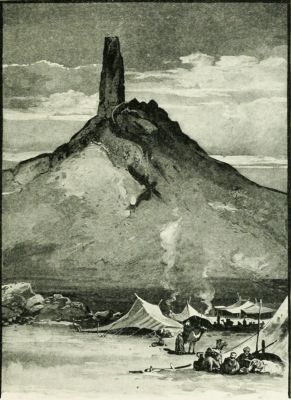 BIRS NIMROUD (SUPPOSED TOWER OF BABEL).
In the interpretation of this "Table of Nations" certain facts and principles are to be borne in mind. 1. It is incomplete; not undertaking to name all the races of mankind, but only those in the Hebrew, Egyptian, and Assyrian sphere of interest. Neither the yellow, the brown, or the black races are represented upon it, and only a portion of the ruddy or white race. 2. It is popular and not scientific. The Orientals never wrote with the precision of modern students. Hence find in this document terms employed in a general and indefinite manner. 3. It is, in reality, geographical rather than racial. For example, when it says "the sons of Canaan," we are not always to infer a literal descent, but a location in the land of Canaan. The names upon this table are generally not those of individuals, but of tribes. In some instances relationship may be indicated; but generally propinquity of settlement is all that can positively be affirmed. 4. It arranges the nations according to zones, in a general direction from northwest to southeast; not by continents, as was formerly supposed. The nations of the Japhetic family are found in Asia and Europe; the Shemites, or Semites, in Asia; the so-called Hamitic races, in Asia and Africa. After the deluge an instinct of migration took possession of the human family. From the original home (long supposed to be near the Caspian Sea, but now uncertain as to locality) clans moved in all directions, and nations arose, occupying different lands.
I. THE JAPHETIC NATIONS.
These belonged to seven families, who are called "sons of Japheth" in Gen. 10:2; and seven others, who are spoken of as his grandsons in Gen. 10:3, 4. These statements are not necessarily to be understood literally. There may have been other sons and grandsons of Japheth; but these were the ones whose names are remembered as the founders of nations. The peoples descended from Japheth belong to what is called the Aryan or Indo-European race.
1. Gomer is named, in Ezek. 38:2-6, as a race opposed to Israel after the captivity. They were probably the people whom the Assyrians called Gimirrai, and the Greeks Kimmerioi. Their name is perpetuated in the Crimea, their early home. A branch of this race moving westward became the Cimbri, who were formidable enemies of Rome; and probably another, the Cymry, settled in the British Isles, and were the ancestors of the Welsh and the Irish. The Celtic races, to which the French partly belong, are descended from this family.
Three of the families descended from Gomer formed separate tribes, named, in the table of nations in Gen. 10:3, after Ashkenaz, Riphath and Togarmah. All of these had homes around or near the Black Sea.
(1.) Ashkenaz is the name of a people spread out of Mysia and Phrygia in Asia Minor. "Ascanios," a Greek form of the word, occurs in Homer as the name of a Mysian and Phrygian prince. It is, however, true that, in Jer. 51:27, Ashkenaz is located in Western Armenia, whither this people had later migrated. Here, also, the Assyrians located them.
(2.) Riphath was formerly supposed to point to the Riphæn Mountains, north of the Danube and west of the Black Sea, but this is very doubtful.
(3.) Togarmah (Ezek. 27:14; 38:6) is identified with the land of Armenia, whose people have a tradition that they are descended from Targom.
2. Magog (called, in Ezek. 38 and 39, Gog, the prefix Ma being thought to signify "land") is generally understood to designate the Scythians.[24]
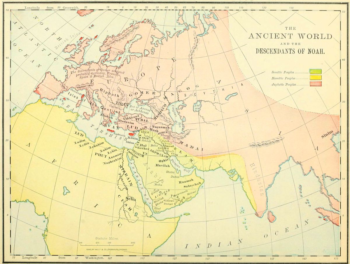 THE ANCIENT WORLD AND THE DESCENDANTS OF NOAH.
3. Madai is everywhere in Scripture the word translated Medes, whose early home was south of the Caspian Sea, whence they marched westward, and conquered the lands as far as the Mediterranean.
4. Javan is the Hebrew term for the Greeks, as is indicated by various references in the Old Testament. It is especially applied to the Ionians (originally called Iafon-es, the descendants of Iafon, or Javan), who were the Grecian people, with whom the Israelites were brought into commercial relations.
Five lands and races are named as subdivisions of the family of Javan in Gen. 10:4, all of which were situated near each other.
(1.) Elishah (or, as in Ezek. 27:7, "the isles of Elishah,") is supposed to refer to the Æolians, inhabiting the isles of the Ægean Sea, from which came the purple dye mentioned in Ezekiel's reference.
(2.) Tarshish was formerly supposed to refer to Tarsus in Cilicia of Asia Minor, on the authority of Josephus, but is now identified with Tartessus in Spain, embracing the coast land from Gibraltar to the Guadalquiver.
(3.) Kittim, or Chittim, was the name applied to the island of Cyprus, of which one of the cities was called Kitium. The name Chittim was also loosely given by the Hebrews to the shores and isles of the Mediterranean.
(4.) Dodanim (or, as in some copies of 1 Chron. 1:7, Rodanim). If the reading Dodanim be preferred, this may point to the Dardanians, a name often applied in the classics to the people of Troy, the famous city of Homer. The other reading, Rodanim, which is preferred by some critics, is supposed to point to the isle of Rhodes, in the Ægean Sea, a home of the ancient Greeks. Thus both Javan and all his sons who founded families were connected with the Greek race.
(5.) The Isles of the Gentiles (Gen. 10:5) in Hebrew refers not only to islands, but all lands bordering upon the sea. Here it refers to the Japhetic colonies on the coasts of the Mediterranean, the Black and the Caspian Seas.
5. Tubal, and 6. Meshech, are generally associated in Scripture. (Ezek. 27:13; 32:26; 38:2, 3; 39:1.) From their associations, they are to be sought near the Caspian and Black Seas, where Herodotus mentions the Tibareni and the Moschi.
7. Tiras (1. Chron. 1:5) was believed by the Jews to refer to the Thracians, southwest of the Black Sea. There is nothing to oppose this view, but no evidence except the similarity of name in its favor.
II. THE HAMITIC RACES.
These are named with greater particularity, because they were those which rose to prominence early in the history, and those with which the Hebrews were brought into closer relations, either as enemies or as friends. Four principal races are given, some of which were greatly subdivided. The homes of these races were in Africa, Eastern Arabia, with a fringe of sea-coast along the eastern Mediterranean, and the great Mesopotamian valley, in which arose the earliest world empires. They have been sometimes called Turanians. It is by no means probable that all these nations should be regarded as the descendants of Ham, the son of Noah. In this list are evidently grouped together some races whose territory was contiguous, but whose physical appearance and language show no relationship.
1. Cush is, throughout the Bible, the word translated Ethiopia. Generally this refers to the region south of Egypt, now known as Abyssinia; but in Gen. 2:13, Isa. 11:11, and Ezek. 38:5, the reference must be to an Asiatic Cush, in Mesopotamia. The subdivisions of the Cushite tribes in Gen. 10:7-12, show that the earliest great Oriental monarchies were of this race. These subdivisions are as follows:
(1.) Seba. These were, probably, the Ethiopians of Meroë, on the Nile, anciently called Saba; in Isa. 43:3 and 45:14, connected with the Egyptians.
(2.) Havilah. This is supposed to refer to Arabia, or at least a part of it.
(3.) Sabtah. This may refer to the Sabbatha, or Sabota, of Pliny and Ptolemy, on the southern shore of Arabia.
(4.) Raamah, with whom are associated his sons or descendants, Sheba and Dedan, occupied the eastern shore of Arabia, near the Persian Gulf.
(5.) Sabtechah. This is unknown, but, from the relation of the previous names, may have been in the southeastern portion of Arabia.
(6.) Nimrod is named as a descendant of Cush (perhaps the only name of an individual in the list), and the founder of the early Babylonian empire.
2. Mizraim is the name everywhere used for Egypt in the Hebrew. The word is in the dual form, representing the two divisions of the country, and corresponding to the two crowns on all the royal effigies. Several branches of this race are especially mentioned.
(1.) Ludim. Not the same with the Lud of verse 22, but from its associations plainly in Africa. The location has been given as Nubia, but is very doubtful.
(2.) Anamim. An unknown people, whose identity was early lost in some other race.
(3.) Lehabim. These are elsewhere in Scripture called Lubim, and were the Libyans, or people of Libya, west of Egypt, on the southern shore of the Mediterranean.
(4.) Naphtuhim. Probably the Na-Ptah of the Egyptian monuments, having their home at Memphis, south of the Delta.
(5.) Pathrusim. Often referred to in the prophets as Pathros, or Upper Egypt.
(6.) Casluhim. An unknown people, perhaps in the vicinity of Goshen.
(7.) Caphtorim. Generally supposed to refer to the people on the island of Crete. With these, and not with the Casluhim, should the Philistim be connected. (See Deut. 2:23, Jer. 47:4, Amos 9:7.)[26]
3. Phut. The word is several times translated Libya, and, from its association with other tribes, should probably be referred to that section in Northern Africa. (See Jer. 46:9; Ezek. 27:10; 30:5; 38:5; Nah. 3:9.) Some of these passages would indicate that there was also an Asiatic branch of this same family.
4. Canaan. The ancient inhabitants of Palestine and Lower Syria, from Gaza to Hamath. In their most flourishing period, just before the conquest by Joshua, they embraced six subdivisions or clans. (See map on page 36, and explanations.)
III. THE SEMITIC RACES. (Gen. 10:21-31.)
The descendants of Shem are placed last in the list of the table of nations, not because their founder was the youngest, but because out of their lines one family is chosen as the especial theme of the history, which thus receives a fitting introduction. Shem was the founder of five great races, and of many subordinate tribes.
1. Elam everywhere is recognized as the name of a province east of the Tigris and north of the Persian Gulf, called by the Greeks Elymais. The name was often applied, in later times, to the whole of Persia, whose capital stood within its territory.
2. Asshur is frequently mentioned in the Old Testament. It was located on the Tigris, having Nineveh as its capital, and its people at one time were rulers of all the lands westward to the Mediterranean.
3. Arphaxad, or Arpachshad (as in the margin of Gen. 11:10), has been supposed to be the ancestor of the Chaldeans, whose home was at the head of the Persian Gulf. The patriarch Abraham belonged to his race, and was born in "Ur of the Chaldees." Another of Arphaxad's descendants was Joktan, from whom arose thirteen tribes, named after Almodad, Sheleph,Hazarmaveth, Jerah, Hadoram, Uzal, Diklah, Obal, Abimael, Sheba (the most important of all in after history, absorbing most of the rest), Ophir, Havilah, and Jobab. All these occupied the southeastern and southern sections of the great Arabian peninsula. The fact that some of these names have already been mentioned in the Hamite genealogies may indicate that the two races became mingled.
4. Lud. This is believed by most scholars to refer to the Lydians, who dwelt on the southwestern border of Asia Minor, and under their king, Crœsus, became a powerful nation. Their history was short, as their empire was conquered by Cyrus the Great.
5. Aram. This is the word uniformly rendered Syria throughout the Bible. The Arameans, or Syrians, occupied the region between Canaan and Phœnicia, on the east, the Euphrates on the north, and the great desert on the west and south. Four branches of this race formed separate tribes. Uz, the race of the ancient Job, was settled in the middle of North Arabia, near Nejd. Huland Gether are supposed (but with slight evidences) to have occupied the country near Lake Merom, where the Geshurites were afterward found. Mash, or, as called in 1 Chron. 1:17,Meshech, may have merged with the Meshech of the Japhetic line.
 OUTLINE MAP FOR REVIEW.
OUTLINE FOR TEACHING.
1. The principal authorities for the map on page 24, and its explanations, are: "Ethnic Affinities," by Canon George Rawlinson; E. H. Browne, in "The Speaker's Commentary"; J. G. Murphy's "Notes on Genesis"; Dillmann, "Commentary on Genesis"; and "The Races of the Old Testament," by A. H. Sayce. To these the student is referred for more thorough discussion of the subject.
2. In teaching, draw on the blackboard a sketch map (no matter how roughly) of the outlines of the coast, as given above, and then write on each place the name of the people occupying it. Take, first, the great divisions of Noah's family; then, the subdivisions; then, the minor tribes. Review the locations as each family is finished. Write on the board only the first syllable of each name, as an aid to memory, as Ar for Arphaxad, Cu for Cush, etc. If the names of each of the three great races are written in chalk of a different color, it will make the distinctions more readily understood.
3. If practicable, by means of a duplicating process, print a sufficient number of copies of the sketch map to supply the class or audience, and let each person, with pencil, place on the map the names of the tribes as they are located. This will greatly add to the interest of the lesson.[27]
REVIEW CHART—THE TABLE OF NATIONS.
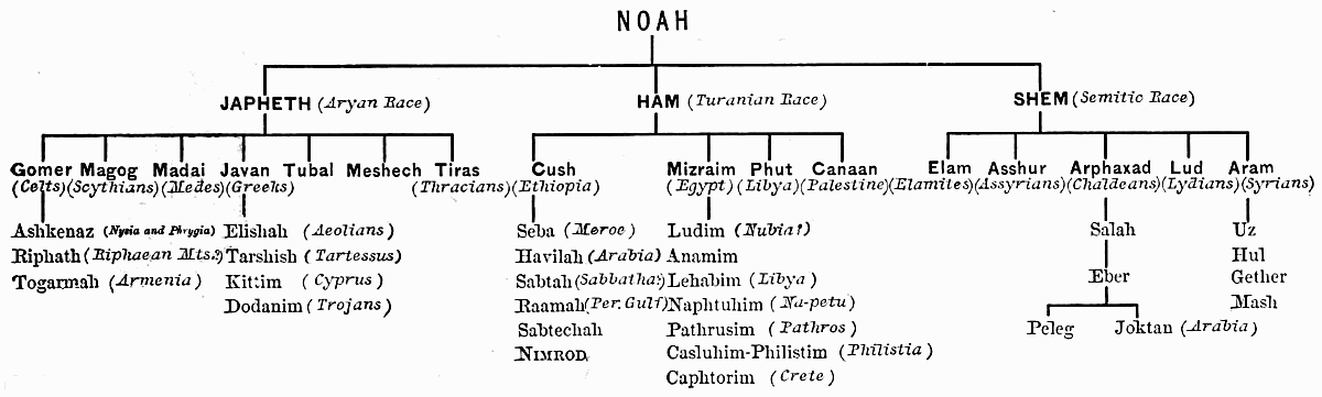
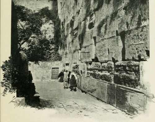 THE JEWS' WAILING PLACE, AT JERUSALEM.
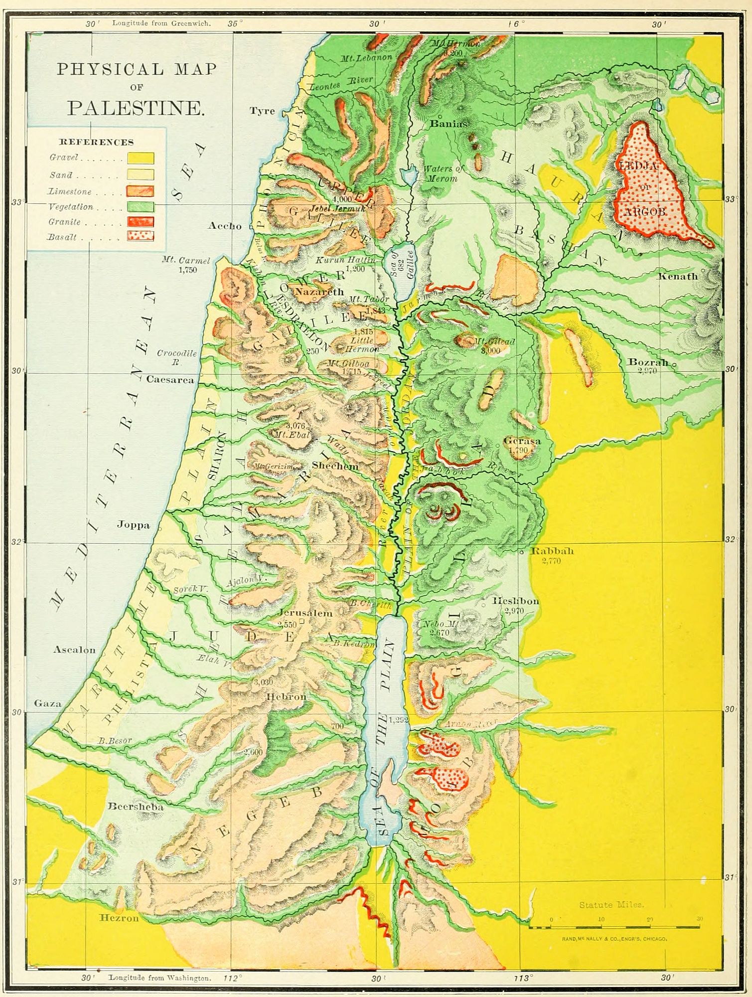 PHYSICAL MAP OF PALESTINE.
PHYSICAL PALESTINE.
I. DIMENSIONS.
The terms Canaan, Palestine and the Holy Land are used with various meanings. The first is the original name, taken from the ancestor of its early inhabitants; the second is a modernized form of the word "Philistine," a race occupying its southwest portion; the third is the name applied to it as the land where the Saviour of the world lived and died. In either one of these three names we may also find three different limitations of meaning. 1. Strictly speaking, the word "Canaan" refers to the country between the Jordan and the Mediterranean; bounded on the north by Mount Lebanon, and on the south by the desert. The name "Palestine" is often given to this section only. This region includes about 6,600 square miles, a territory smaller than the State of Massachusetts by 1,200 square miles. 2. Palestine Proper, the Land of the Twelve Tribes, embraces both Canaan and the region east of the Jordan, loosely called Gilead, though that name strictly belongs to but one section of it. Palestine Proper is bounded on the north by the river Leontes, Mount Lebanon and Mount Hermon; east by the Syrian desert, south by the Arabian desert, and west by the Mediterranean; and forms a sort of parallelogram, embracing an area of about 12,000 miles, about the size of Massachusetts and Connecticut. 3. The Land of Promise (Num. 34), in its largest meaning, extended from the "Entrance of Hamath," on the north, to Mount Hor, Kadesh-barnea, and the "River of Egypt" (Wady el Arish); and from the Euphrates to the Mediterranean; including an area of 60,000 square miles, a little less than that of the five New England States. This was realized only during a part of the reigns of David and Solomon. Not all of even Palestine Proper was possessed by Israel during most of its history; for the plain along the sea-shore was held by the Philistines on the south, and by the Phœnicians on the north.
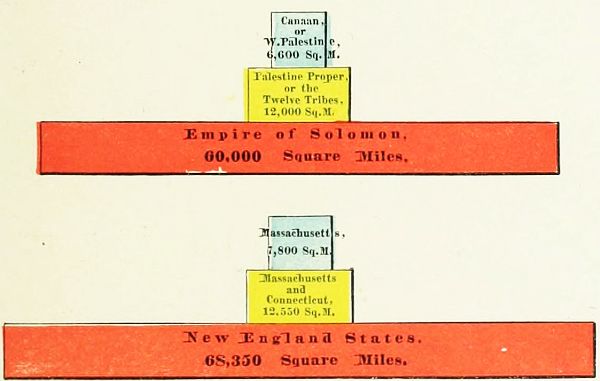 COMPARATIVE AREAS OF PALESTINE AND NEW ENGLAND.
II. NATURAL DIVISIONS.
The divisions of Palestine made by the natural features of the country are four, generally parallel to each other: 1. The Maritime Plain. 2. The Mountain Region. 3. The Jordan Valley. 4. The Eastern Table-Land.
1. The Maritime Plain lies along the coast of the Mediterranean for the entire length of the country, broken only by Mount Carmel, north of which it is quite narrow; but immediately south of the mountain it is 8 miles wide, thence widening to 20 miles at the southern boundary of the country. It is an undulating surface of low hillocks of sandy soil, from 100 to 200 feet above the sea-level, and very fertile. In the Old Testament period it was but little occupied by the Israelites, whose home was on the mountains. It is divided into four portions. North of Mount Carmel a narrow strip is called Phœnicia. Directly east of Mount Carmel the level country is pressed inward, and lies between the mountains, forming the remarkable Plain of Esdraelon, physically belonging to the Maritime Plain, but geographically to the Mountain Region. South of Mount Carmel lay Sharon; and further southward was Philistia, a land whose people, the Philistines, were long the enemies of Israel, and have since given the name Palestine to the whole land.
2. The Mountain Region, between the Jordan Valley and the Plain, is the backbone of the country, and was the principal home of the Israelites. It is a continuation of the Lebanon range of mountains, and extends southward to the desert. It is divided into five sections, by natural rather than political lines of boundary. (1.) In Upper Galilee the mountains average a height of 2,800 feet above the sea, and Jebel Jermuk, the highest peak, is 4,000 feet high. (2.) In Lower Galilee the hills are about 1,800 feet high, their southeastern slopes precipitous, the northern and northwestern gentle. In this section lies the Plain of Esdraelon, about 250 feet above the sea, 9 miles across, and 14 miles north and south. (3.) The Hill Country of Samaria and Judæa, called in the Old Testament "Mount Ephraim," and "the mountains of Judah," is from 2,000 to 3,000 feet high, consisting of mountain and valley, with the watershed midway between the Jordan and the sea. Near the Dead Sea is the Wilderness of Judæa, an uninhabitable region, without verdure, and penetrated with ravines and caves; sometimes called Jeshimon. (4.) TheShefelah, or "low hills," are the foot-hills of the Mountain Region, forming a natural[30] terrace 500 feet above the sea-level, on the western side of the mountains, between them and the Plain. This extends along both Samaria and Judæa. (5.) The Negeb, a word meaning "dry," translated "South Country" in the Bible, begins just south of Hebron, and slopes southward to the Arabian desert, in a series of hills much lower than those in the northern section.
3. The Jordan Valley is a remarkable depression, beginning at the sources of the river, and plowing a gorge which grows deeper as it goes southward. At the springs of the Jordan it is 1,700 feet above the sea, with lofty mountains on each side, Hermon and Lebanon. At lake Merom it is 7 feet above the level of the sea. Below Merom it descends by a fall of 60 feet to the mile, and at the Sea of Galilee is 682 feet below the Mediterranean. Here begins the Ghor (its Arab name, meaning "hollow"), a gorge 65 miles long to the Dead Sea, and descending 610 feet further in its depth, with a barrier of cliffs on either side, from 2 to 8 miles apart, except at the "Plain of Jordan," or "Plain of Jericho," just north of the Dead Sea, which is 14 miles wide. This plain lies 400 feet above the level of the Dead Sea, and is encompassed by mountains which rise above it about 4,000 feet.
4. The Eastern Table-Land is a lofty plateau, east of the Jordan. The mountains on this side are higher and more steep than are those on the west; and from their summit a plain stretches away to the great Syrian desert. It is mostly fertile, and especially adapted to pasturage. On the north is Bashan, now called "the Hauran," in the centre lies Gilead, and south was the land of Moab.
III. THE WATERS OF PALESTINE.
These may be noticed under three heads: 1. The River Jordan. 2. The Three Lakes. 3. The Brooks, or mountain torrents.
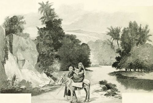 THE RIVER JORDAN.
1. The River Jordan has three sources. (1.) The most northerly is at Hasbeiya, on Hermon. (2.) The largest stream proceeds from a great spring at the ancient Dan, now Tell el Kady. (3.) The one recognized as the source by the Jews is at Banias, near the ancient Cæsarea Philippi. It may be divided into three sections: from Hasbeiya to Lake Merom, about 40 miles; from its entrance into Merom to the Sea of Galilee, 15 miles; and from the northern end of that lake to the Dead Sea, 79 miles,—making its direct length 134 miles, though by its windings the channel is about 200 miles long. In its progress it falls over 3,000 feet, an average fall of over 22 feet to the mile. It varies in width from 80 to 180 feet, and in depth from 5 to 12 feet.
2. The Three Lakes are: (1.) Merom, now called Huleh, a triangular sheet of water three miles across, located in a swamp in Northern Galilee. (2.) The Sea of Galilee, called Chinnereth in the Old Testament, a pear-shaped lake, 14 miles long, and 9 wide. (3.) The Dead Sea, 46 miles long, its surface 1,290 feet below the level[31] of the Mediterranean, and in some places 1,300 feet deep, though the great lagoon on its southern end is not more than 20 feet deep.
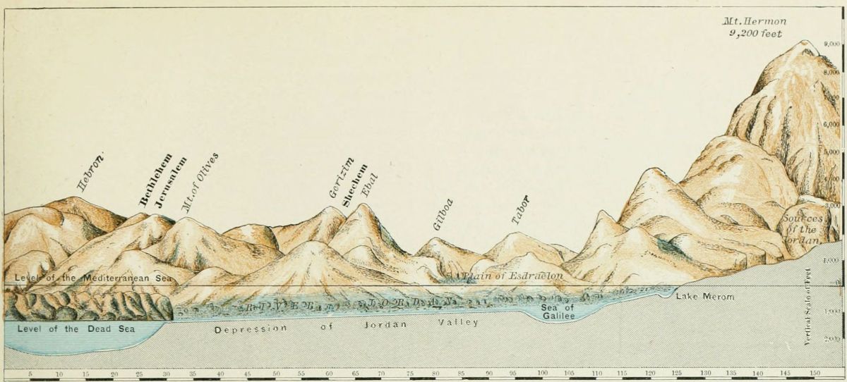 SECTION OF PALESTINE FROM NORTH TO SOUTH.
3. The Brooks, or mountain torrents, are an important feature in the country. They are dry for most of the year, but during the winter are large and rapid. (1.) On the east of the Jordan Valley are: (a) the Hieromax (now called the Jarmuk), flowing from the highlands of Bashan into the Jordan, south of the Sea of Galilee; (b) the Jabbok (now Zerka), descending from the table-land, and entering the Jordan a little south of midway between the Sea of Galilee and the Dead Sea; (c) the Arnon (now Mojeb), entering the Dead Sea about the middle of its eastern shore. (2.) Flowing from the Mountain Region eastward are: (a) the Farah, "the waters of Enon" (John 3:23); (b) the brook Cherith (1 Kings 17:3), perhaps Wady Kelt, near Jericho; (c) the brook Kedron, running past Jerusalem, eastward, into the Dead Sea, probably the Wady en Nar. (3.) Flowing into the Mediterranean are: (a) the Leontes (now Litany), the northern boundary of Palestine, a stream almost as long as the Jordan; (b) the Kishon, "that ancient river" (Judg. 5:21), watering the Plain of Esdraelon; (c) the brook Besor (Wady es Sheriah), near the southern frontier. Others might be named, but these are the most important, though not in all cases the largest.
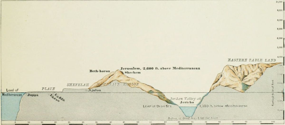 SECTION OF PALESTINE FROM EAST TO WEST.
IV. THE MOUNTAINS OF PALESTINE.
These may be considered either in order of height or of location. The diagram groups the principal mountains[32] in the relation of their comparative height above the sea-level; we may notice them in their order of location. They naturally divide into two sections: 1. Those of the Mountain Region west of Jordan. 2. Those of the Eastern Table-Land.
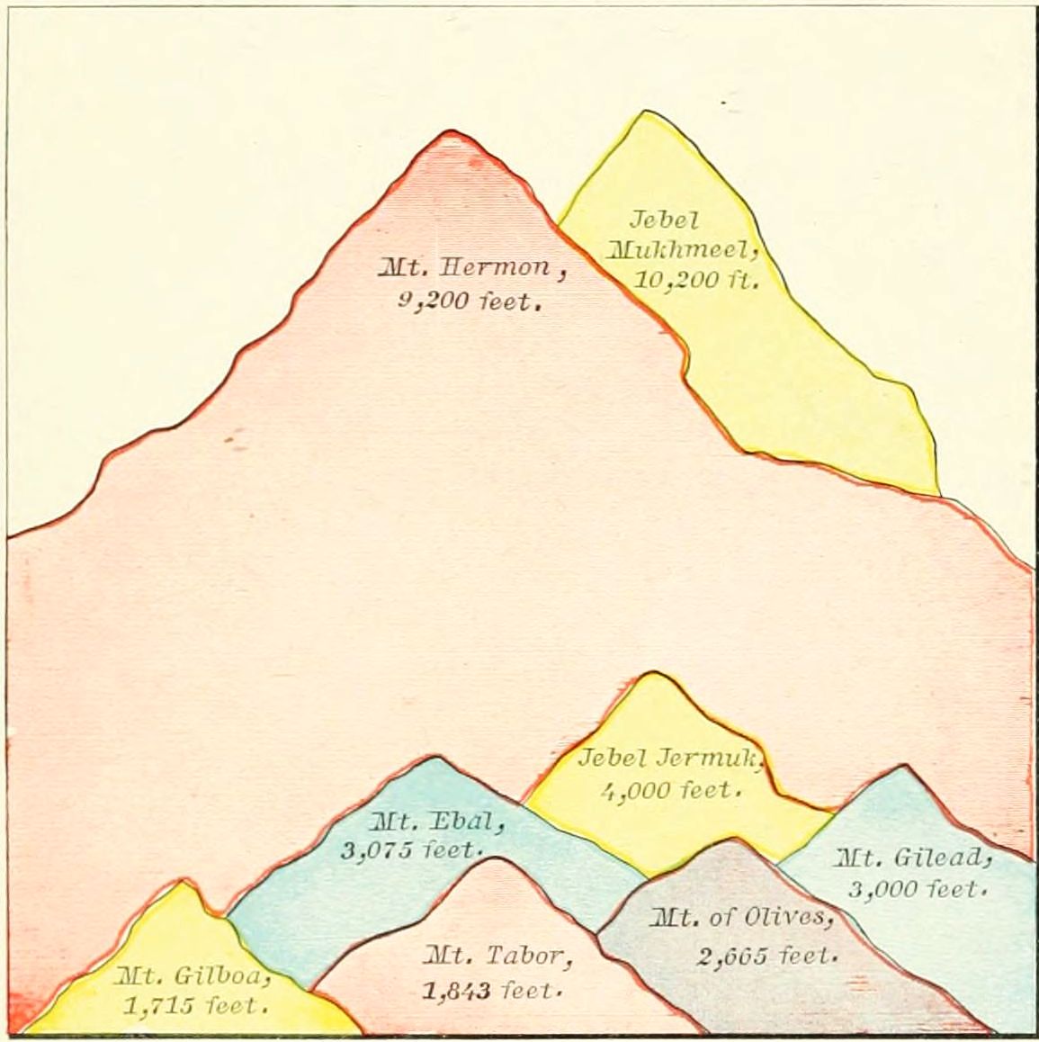 COMPARATIVE HEIGHT OF MOUNTAINS IN PALESTINE.
Beginning at the northern boundary of Palestine, we find: 1. Mount Lebanon, "the white mountain," a range of lofty mountains stretching northward, parallel with the sea, generally about 5,000 feet high, but at its highest point, Jebel Mukhmeel, 10,200 feet high. 2. The highest point in Galilee is Jebel Jermuk, northwest of the Sea of Galilee, 4,000 feet high. 3. West of the Sea of Galilee is Kurûn Hattin, "the horns of Hattin," the traditional "Mount of the Beatitudes," 1,200 feet high. 4. At the northeastern corner of the Plain of Esdraelon is Mount Tabor, a symmetrical cone, the battle-field of Deborah and Barak, 1,843 feet high. 5. A short distance to the south stands Little Hermon, "the Hill of Moreh," now Jebel el Duhy, 1,815 feet high. 6. Southward still is Mount Gilboa, the place of Gideon's victory and of King Saul's defeat, 1,715 feet high. 7. Sweeping around the southern border of the Plain of Esdraelon to the Mediterranean Sea is Mount Carmel, at its highest point 1,750 feet, but 500 as it meets the sea. These last four mountains form the boundary of the Plain of Esdraelon. In the land of Samaria, which we now enter, are but two important elevations: 8. Ebal, the mountain of the curses, 3,075 feet; 9. Directly opposite, Gerizim, the mountain of the blessings, 2,850 feet. The principal peaks in Judæa are the following: 10. Mount Zion, the seat of David's castle, 2,550 feet; 11. Across the valley of the Kedron eastward, the Mount of Olives, 2,665 feet; 12. Mount Hebron, 3,030 feet. South of Hebron the land slopes away to the level of the desert.
The Eastern Table-Land has fewer elevations, and is generally less noticed in the Scriptures. 1. On the north rises Mount Hermon, 9,000 feet high, the southern end of the range known as Anti-Lebanon, or "Lebanon toward the sun-rising." 2. South of the river Hieromax is Mount Gilead, about 3,000 feet high. 3. Near the northern end of the Dead Sea is Mount Nebo, 2,670 feet high, on a "shoulder" of which, Mount Pisgah, Moses beheld the Promised Land, and died.
V. THE PLAINS OF PALESTINE.
These have been already noticed, to some extent, but may be named together. Upon the Maritime Plain, we notice: 1. Phœnicia, a very narrow strip along the Mediterranean, north of Mount Carmel, never possessed by the Israelites, and having Tyre and Sidon as its principal cities. 2. Directly south of Mount Carmel, Sharon, having Cæsarea and Joppa as its most important places. 3. Still further south, Philistia, the land of Israel's ancient enemies, containing several cities, of which Gaza and Ashkelon (afterward Ascalon) were chief. Upon the Mountain Region we find imbedded, 4. The Plain of Esdraelon, a Y-shaped region, 250 feet above the sea-level, surrounded by mountains, and situated between Mounts Carmel, Tabor and Gilboa. 5. The Negeb, or South Country, between Hebron and the desert, in Southern Judæa, may be regarded as a plain, though of rolling character, as its hills are not so high as those on the north. 6. In the Jordan Valley, just north of the Dead Sea, is a place called "the Plain of Jordan," or "the Plain of Jericho," the site of the destroyed "cities of the plain." 7. In the northern section of the Eastern Table-Land is the vast highland known as "the Hauran," anciently called Bashan, watered by the streams which form the Hieromax river.
OUTLINE FOR REVIEW.
I. Dimensions. 1. Canaan. 2. Palestine (Twelve Tribes). 3. Land of Promise.
II. Natural Divisions. 1. Maritime Plain. 2. Mountain Region (Upper Galilee, Lower Galilee, Hill Country, Shefelah, Negeb). 3. Jordan Valley (Merom, Galilee, Dead Sea). 4. Eastern Table-Land (Bashan, Gilead, Moab).
III. Waters. 1. Jordan (sources, sections). 2. Lakes (Merom, Galilee, Dead Sea). 3. Brooks. (1.) East: Hieromax, Jabbok, Arnon. (2.) Mountain Region: Farah, Cherith, Kedron. (3.) Maritime Plain: Leontes, Kishon, Besor.
IV. Mountains. 1. West of Jordan: Lebanon, Jermuk, Hattin, Tabor, Little Hermon, Gilboa, Carmel, Ebal, Gerizim, Zion, Olives, Hebron. 2. East of Jordan: Hermon, Gilead, Nebo.
V. Plains. 1. Phœnicia. 2. Sharon. 3. Philistia. 4. Esdraelon. 5. Negeb. 6. Jordan. 7. Hauran.
THE JOURNEYS OF THE PATRIARCHS.
At the close of the eleventh chapter of Genesis a change is made in the subject of the Bible story. Thus far it has been a history of the entire race; but from this point to the close of Genesis a single family is brought into prominent notice, and the rest of the tribes of men are referred to only incidentally. The family of Abraham, of Semitic origin, deserve all their prominence in sacred history, since through them the true religion was perpetuated until the world was ready for its wider dissemination in the gospel period.
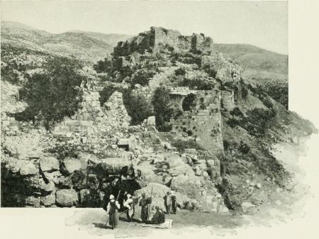 MUGHEIR, SUPPOSED TO BE UR OF THE CHALDEES.
I. THE JOURNEYS OF ABRAHAM.
These extend over nearly all the lands of the Old Testament, from Chaldea to Egypt. They represent the separation of a Semitic clan from the great body of the race, which was then ruled by an Elamite dynasty; and they bring to our notice the political relations of the world about two thousand years before Christ, in the early Chaldean period of the East.
1. From Ur to Haran. (Gen. 11:27-32.) The family of Abraham (then called Abram) lived at Ur of the Chaldees, probably Mugheir, south of the Euphrates, and an early seat of empire. Thence, at God's call, they migrated, moving up the Euphrates to Haran, in Mesopotamia, probably the Roman Carrhæ, and the modern Haran, on the river Belik, 50 miles above its entrance into the Euphrates. Here the family remained until the death of Terah, Abraham's aged father, whose traditional tomb is still shown.
2. From Haran to Canaan. (Gen. 12:1-9.) A branch of the family, the descendants of Abraham's brother Nahor, settled in Haran; but Abraham and his nephew Lot moved on southward, past Damascus, to the land of Canaan. They paused first at Shechem, and afterward at Bethel, at each place building an altar; but after a time removed further southward, impelled by the dearth of food in the land.
3. The Visit to Egypt. (Gen. 12:10-20.) The famine caused a removal of the entire clan to Egypt, where the beauty of Sarah was the occasion of Abraham's deception, of Pharaoh's wrong, and of Abraham's expulsion from the land. He returned to his former abode at Bethel. (Gen. 13:3, 4.)
4. The Removal to Hebron. (Gen. 13:5-18.) This was occasioned by the scarcity of pasture for the immense flocks and herds of Abraham and Lot. The two chieftains made a division of the land, Lot choosing the Jordan Valley, north of the Dead Sea, near the city of Sodom, and Abraham the highlands around Hebron, anciently Kirjath-arba, now known by Abraham's title,el Khalil, "The Friend," i. e., of God.
5. Pursuit of the Elamites. (Gen. 14.) At that period the early Babylonian empire, under Amraphel or Hammurabi (see p. 91), was at the height of its power. Its king governed Elam, Chaldea, Assyria, Mesopotamia, and most of Palestine. Chedorlaomer, the head of the united peoples, led his armies against the aboriginal races east of the Jordan. (See Map of Palestine Before the Conquest, and description, on page 37.) After subduing them he passed around south of the Dead Sea, smote the Amorites in the mountains near Hazezon-tamar, afterward En-gedi, and poured his host down upon the Jordan Valley. The cities on the north of the Dead Sea, Sodom and Gomorrah, with their dependent villages, being unable to stay his progress, were ravaged, and their inhabitants (including Abraham's nephew Lot) carried away captive, up the valley. News of the invasion came to Abraham, and he instantly gathered his servants and allies, and pursued the marauders. He overtook them near Laish, afterward Dan, now Tell el Kady, attacked them by night, pursued them as far as Hobah, near Damascus, and brought back the booty and[34] the prisoners. On the return took place the remarkable interview with Melchizedek, a priest-king over the city of Salem, perhaps the place afterward Jerusalem. After the return to Hebron the following events occurred: 1. The covenant of God with Abraham. (Gen. 15.) 2. The birth of Ishmael. (Gen. 16.) 3. The destruction of Sodom and Gomorrah. (Gen. 18, 19.) These cities were probably located on the plain of Jordan, north of the Dead Sea, and not on the south, as formerly supposed; but all traces of them have entirely disappeared.
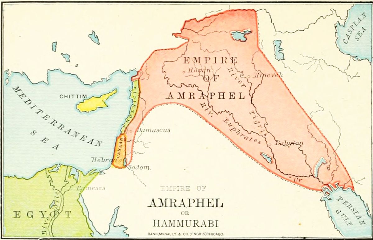
6. The Settlement at Beersheba. (Gen. 20-25.) After the destruction of the cities of the plain, Abraham moved southward, and made his home at Beersheba, on the desert border, now Bir es Seba. Here he spent most of his later years, as after various journeys we find him each time encamped at Beersheba.
7. The Offering of Isaac. (Gen. 22.) From Beersheba Abraham took his son Isaac, at God's command, to offer him as a burnt offering in "the land of Moriah." Some authorities accept the Samaritan tradition, that this place was Mount Gerizim; but we see no sufficient reason to dissent from the general view, that it was Mount Moriah, at Jerusalem, ten centuries afterward the site of the Temple. After this sublime token of his faith in God, the patriarch returned to his tent at Beersheba.
8. The Burial of Sarah. (Gen. 23.) We find Abraham again at Hebron, in his old age. Here Sarah died and was buried in the cave of Machpelah. This is undoubtedly covered by the Mohammedan mosque so sacredly guarded against the intrusion of travelers. The after events of Abraham's history may have taken place at Hebron or at Beersheba, as neither place is named as his residence at the time of Isaac's marriage or his own death. He was buried in the family sepulchre at Hebron, beside the body of Sarah.
II. THE JOURNEYS OF ISAAC.
The life of Isaac, though longer than the lives of Abraham and Jacob, was spent in a comparatively small range of territory, and with comparatively few events. We have not noted upon the map the lines of his journeyings; but the localities may be seen, as far as they are identified, upon the map of Palestine, on page 58.
The homes of Isaac were as follows: 1. Beer-lahai-roi, "Well of the Life of Vision," i. e., where life remained after seeing God; an unknown locality in the south of Canaan, between Bered and Kadesh. It was so named by Hagar, after meeting an angel, before the birth of Ishmael. (Gen. 16:13.) 2. Gerar. (Gen. 26:1.) This was the chief city of the Philistines in that age; and is now called Kirbet el Gerar. The wells dug by Isaac, and seized by the Philistines, were probably in the region near this city. 3. Rehoboth (Gen. 26:22) is probably at the Wady (Valley)er Ruhaibeh, south of Beersheba. 4. Beersheba. (Gen. 26:23-35.) Here he made a treaty of peace with the Philistine king, and remained for many years. It was his home during the strife of Jacob and Esau, and from this place Jacob departed on his long visit to Haran. (Gen. 28:10.) 5. Hebron. (Gen. 35:27.) Here, beside the tomb of his parents, Isaac at last met his son Jacob, and here he died and was buried, at the age of 180 years.
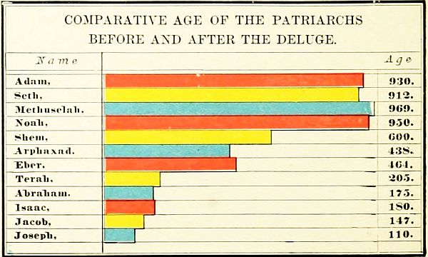 COMPARATIVE AGE OF THE PATRIARCHS BEFORE AND AFTER THE DELUGE.
III. THE JOURNEYS OF JACOB.
The life of Jacob is related with more of detail than that of any other person in Old Testament history; yet there is great uncertainty concerning the division of its periods. His first sixty years were passed near Beersheba; then twenty years in Haran, and fifty years in[35] Canaan (though some of the best chronologers allow forty years in Haran, and thirty years in Canaan); and seventeen years in Egypt. The principal places named in Jacob's journeys are: 1. Beersheba, now Bir es Seba, a well-known place in the south of Palestine. 2. Bethel, now Beitin, 10 miles north of Jerusalem. 3. Haran, now bearing the same name. (See under Abraham's life, Journey No. 1.) 4. Mizpah, called also Jegar-sahadutha, "the heap of witness," perhaps the important place afterward known as Ramoth-gilead, now es Salt, 13 miles south of the Jabbok. But this seems too far south to represent the event, and we are inclined to place it at some unknown mountain between the Jabbok and the Hieromax. 5. Mahanaim, probably at Mahneh, 10 miles north of the Jabbok. 6. Peniel, afterward Penuel, unknown, but somewhere on the brook Jabbok. 7. Succoth, "booths," recently identified as Tell Darala, a mile north of the Jabbok, in the Jordan Valley. 8. Shalem, "peace." If this refers to a place, it is Salim, 3 miles east of Shechem. But some read the sentence, "Jacob came in peace [i. e., in safety] to Shechem." (Gen. 33:18.) 9. Ephrath, the place of Rachel's death and burial, near Bethlehem.
The Journeys of Jacob may be arranged as follows:
1. The Flight to Haran. (Gen. 28:10-29:14.) Fearing the vengeance of Esau after the stolen blessing, Jacob hastily left his home at Beersheba, and journeyed northward to Haran. At Bethel he saw the vision of the heavenly ladder, and arrived safely at Haran, distant 450 miles from Beersheba. Here he remained either 20 or 40 years, according to different views, and married his two wives.
2. The Return to Canaan. (Gen. 31-33.) At Mizpah he made a treaty with Laban; at Mahanaim was comforted by a vision of angels; at Peniel wrestled with "the angel of God," and was reconciled to his brother Esau; and at Salim (if that be the name of a place), near Shechem, he rested in the Land of Promise.
3. The Residence in Canaan. (Gen. 34-45.) The slaughter of the Shechemites by Simeon and Levi, caused Jacob to move his increasing clan further south. At Bethel he renewed the covenant with God. (Gen. 35:1-15.) Near Ephrath, or Bethlehem, his beloved wife Rachel died and was buried. (Gen. 35:10-20.) At Hebron he met once more his aged father, and remained during most of his after-life in the land. (Gen. 35:27.) While Jacob was living at Hebron, Joseph was sold a slave to the Midianites, at Dothan, on the southern slopes of Mount Gilboa, and by them taken down to Egypt. (Gen. 37.)
4. The Descent into Egypt. (Gen. 45-50.) At the invitation of Joseph, then prince in Egypt, Jacob left Hebron to go down into Egypt. At Beersheba he offered sacrifices, and received divine guidance. His home was fixed in the Land of Goshen, a small but fertile district between the eastern channel of the Nile and the desert, the modern province of es Shurkiyeh, including the Wady Tumilat. Here the family of Jacob remained until they became "a great nation," a period variously estimated at from 200 to 400 years, or even longer.
5. The Burial Procession. (Gen. 50.) After the death of Jacob, his embalmed body was borne from Egypt to Hebron. The direct route was not taken, probably on account of the hostility of the Philistine and Amorite tribes; but the procession passed around the south of the Dead Sea, through the land of Moab, and crossed the Jordan at Abel-mizraim, near Jericho, a place afterward known as Beth-hoglah; and thence to Hebron, where the last of the three fathers of the chosen people was laid to rest in the ancestral sepulchre.
OUTLINE FOR REVIEW.
I. Journeys of Abraham. 1. Ur to Haran. 2. Haran to Canaan. (Shechem, Bethel.) 3. Visit to Egypt. (Return to Bethel.) 4. Removal to Hebron. 5. Pursuit of Elamites. (Dan, Hobah, Salem.) 6. Settlement at Beersheba. 7. Offering of Isaac. (Moriah.) 8. Burial of Sarah. (Hebron.)
II. Journeys of Isaac. 1. Beer-lahai-roi. 2. Gerar. 3. Rehoboth. 4. Beersheba. 5. Hebron.
III. Journeys of Jacob. 1. Flight to Haran. (Beersheba, Bethel, Haran.) 2. Return to Canaan. (Mizpah, Mahanaim, Peniel, Shechem.) 3. Residence in Canaan. (Bethel, Bethlehem, Hebron, Dothan.) 4. Descent into Egypt. (Beersheba, Goshen.) 5. Burial Procession. (Abel-mizraim, Hebron.)[36]
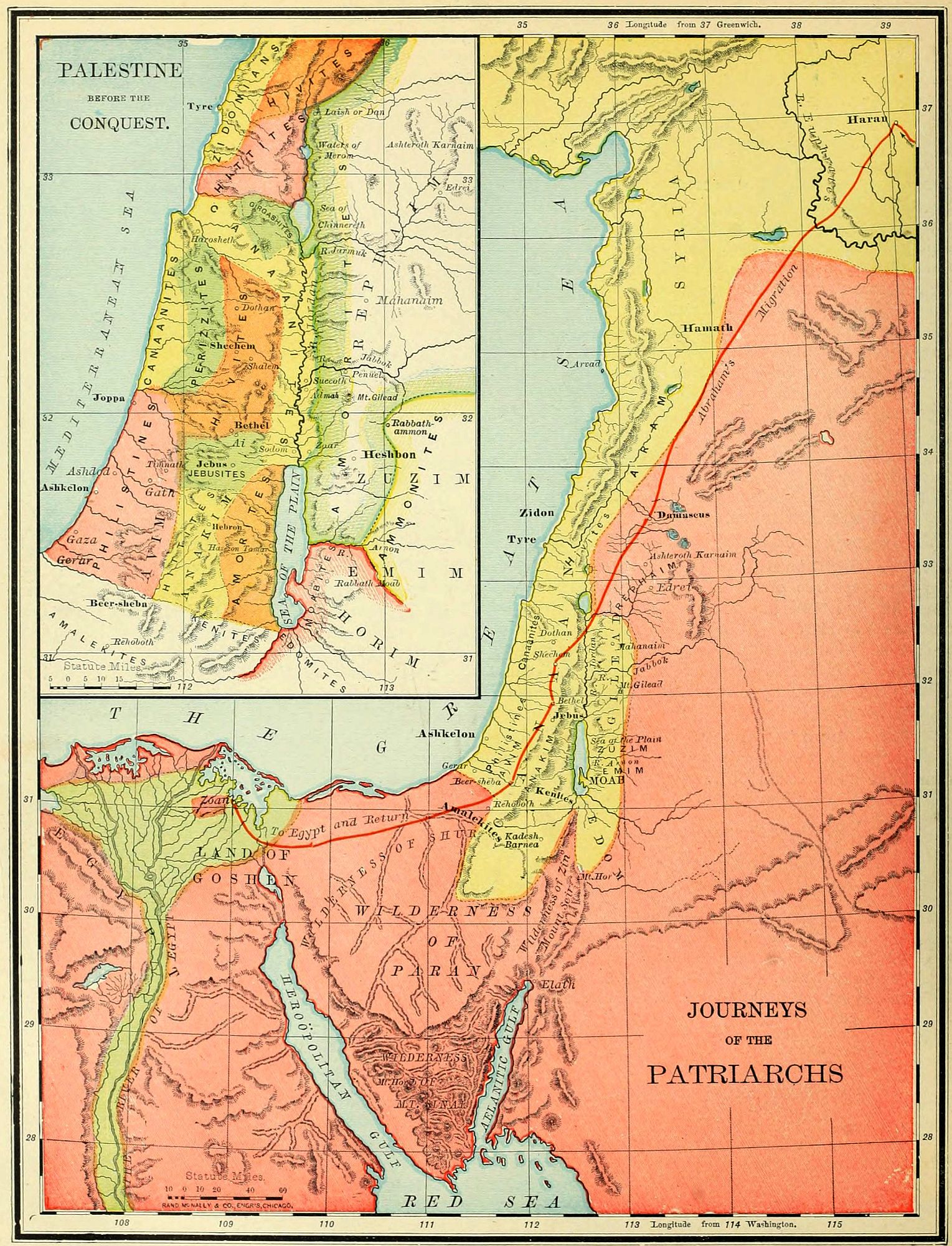
PALESTINE BEFORE THE CONQUEST.
The knowledge which we possess of the inhabitants of Palestine before the 13th century B.C. is quite scanty. The names of tribes, more or less settled, are given; but we know very little of their language, customs or origin. The description of Palestine during the first eight hundred years after the Deluge may be arranged as follows: 1. The Earliest Inhabitants. 2. The Tribes of the Patriarchal Era. 3. The Nations at the Time of the Conquest. 4. The Surrounding Nations.
I. THE EARLIEST INHABITANTS.
 JERICHO AND THE JORDAN.
In most lands the earliest people have been of an unknown race, as the mound builders of America and the cave dwellers of Europe. Very early in the history of the race a people entered Palestine, and settled upon both sides of the Jordan, generally among the mountains. They were remembered by different names in various parts of the country, but the names show the dread inspired by them among the later tribes. They were doubtless of one race, but whether of Hamitic or Semitic stock is uncertain; and their history is as unknown as their origin. They were already in their decline in the times of Abraham, when the Canaanite races, the second series of inhabitants, were in possession of the land. They belonged to six tribes or divisions, each having a different name and location, but all bearing the same characteristics, and all regarded as giants by those who came after them. Our principal authorities concerning these archaic peoples are Gen. 14:5-7, and Deut. 2:10-23.
1. The Rephaim, "lofty men," are frequently named in the Old Testament, the word being generally translated "giants." In the age of Abraham they were living in the highlands of Bashan, where their capital, Ashteroth Karnaim, "the two-horned Ashtaroth," was taken by the Elamite king, Chedorlaomer, the earliest conqueror in Bible history. By degrees they lost their nationality and were merged with the Amorites, over whom one of their race, the gigantic Og, king of Bashan, ruled at the time of the conquest. They may have settled also west of the Jordan, near what was afterward Jerusalem, since a locality in that vicinity (see map on page 82) was long afterward known as "the Valley of the Rephaim." (2 Sam. 5:18.)
2. The Zuzim, "tall ones," are supposed to be the same people with those who in Deut. 2:20 are called Zamzummim. They occupied the eastern table-land, south of Bashan and Gilead. Their capital was Ham, a city not yet identified, unless it was (as some suppose) the place afterward known as Rabbath Ammon. These people were also giants, like the Rephaim (Deut. 2:21), were also overswept in the raid of Chedorlaomer (Gen. 14:5), and during the time of the Israelites' sojourn in[38] Egypt, were dispossessed by the Ammonites, who occupied their country afterward, until in turn driven out by the Amorites.
3. The Emim, "terrible ones," were south of the Zuzim, and therefore directly east of the Dead Sea. They were overcome by Chedorlaomer at Shaveh Kiriathaim, "the dale of the two cities," and their land was afterward occupied by the Moabites.
4. The Horim, "cave dwellers," or Horites, occupied Mount Seir, south of the Dead Sea. Their genealogy is given in Gen. 36:20-30, and 1 Chron. 1:38-42. They lived in caves, which are still found in great numbers through that region. They were beaten by Chedorlaomer, and subsequently dispossessed by the descendants of Esau, the Edomites.
5. The Avim, "ruins," or "dwellers in ruins," lived in the Shefelah, or foot-hills, between the Philistine plain and the mountains of Judah. (Deut. 2:23; Josh. 13:2, 3.) They were early conquered by the Caphtorim, a Philistine race, and were in a depressed condition at the time of the entrance of the Israelites. The word Hazerim (Deut. 2:23) means "villages," or "nomad encampments," showing that they were not a settled, but a wandering people.
6. The Anakim, "long-necked ones." The name may refer either to their size, or their strength (which in Hebrew comes from a word similar to neck). They were descendants of Arba, and divided into three clans, named Sheshai, Ahiman and Talmai. (Josh. 14:15; 15:14.) Their principal home was at Hebron, called by them Kirjath-arba; but they also occupied a city near it, called Kirjath-sepher, or "book-town," a name which is suggestive of a national literature. Unlike the other races, they seem to have maintained a foothold in the presence of the incoming Canaanite races, and their gigantic appearance struck terror to the Israelite spies during the wandering. (Num. 13.) But they were conquered by Caleb (Josh. 14), and their remnant, driven from the mountains, mingled with the Philistines of the sea-coast plain. One family of this race remained as late as the days of David, that of Goliath and his brothers. (1 Sam. 17:4; 2 Sam. 21:15-22.)
II. THE TRIBES OF THE PATRIARCHAL ERA.
The chosen family came to Palestine about 1921 B.C., according to the common chronology, but probably from two to four hundred years earlier. At this time these earliest races were already superseded in nearly all the land by later tribes, of Hamitic origin, with which the patriarchs were often brought into contact. Those tribes were often called Canaanites, because the nation of that name was both the original stock and in possession of the richest and best portion of the land.
We notice these tribes, as far as practicable, in the order of their location in the four great natural divisions of the country: the tribes of the maritime plain, those of the mountain region, those of the Jordan Valley, and those of the eastern table-land.
1. Beginning at the north, on the narrow plain by the Mediterranean Sea, we find the Zidonians, with their two great cities, Zidon the earlier, and Tyre the later. Perhaps the latter city was not yet founded in the patriarchal age. These people were early famous as the traders of the Mediterranean world, having commercial relations as far as Spain. They occupied a narrow strip of territory between Mount Lebanon and the sea, north of Mount Carmel. Their country was never possessed by the Israelites, and most of the time the relations between the two races were peaceful.
2. Next in order of location we come to the Canaanites proper, or that branch of the descendants of Canaan which retained the family name. While all the tribes of Palestine are often called Canaanites, as descended from one stock, the name strictly belongs only to people who lived in two sections of the country. The word means "lowlanders," and was applied particularly to those dwelling on the maritime plain, on both sides of Mount Carmel, the plain of Esdraelon and that of Sharon; and to those in the Jordan Valley. These together constituted "the Canaanites on the east and on the west." (Josh. 11:3.) They occupied the richest and most valuable portions of the land. The only city on the coast belonging to the Canaanites existing during the patriarchal age was Joppa, still standing. The Canaanite cities in the Jordan Valley were the "five cities of the plain," Sodom, Gomorrah, Admah, Zeboim and Zoar, of which all except the last were destroyed by the visitation of God. (Gen. 19.) Their location was in the plain on the north of the Dead Sea, and there is no reason to suppose that they are covered by its waters. In the time immediately before the conquest we find Jericho has arisen in the place of the destroyed cities, and not far from their site, as the most important city of the Jordan Valley.
3. South of the Canaanites, on the maritime plain, were the Philistines. "Emigrants" is the meaning of the word, supporting the view that they came from Caphtor, or Crete, which is but little more than a surmise. They were related to the Egyptians, and hence were of Hamitic stock. They came to the land before the time of Abraham, drove out and subdued the earlier Avim (Deut. 2:23), or Avites, and had frequent dealings with Abraham and Isaac. In the patriarchal age their principal cities were Gaza and Gerar; but before the conquest they had moved northward, and were a powerful confederacy of five cities: Gaza, Ashkelon, Ashdod, Gath and Ekron. (Josh. 13:3.) Their territory, if taken at all during the campaigns of Joshua, was soon reconquered, and the Philistines were the most dangerous enemies of Israel during all the period of the Judges. In David's time they were subjected; but not until the Maccabean age were they fully conquered, and their land made a part of Israel.
4. We turn now to the tribes of the mountain region, beginning, as before, at the north. As these northern regions are not alluded to in patriarchal history, and[39] only very briefly named in the annals of the conquest, it is not easy to determine which of the tribes occupied them. But, from allusions in Josh. 1:4 and 11:3, and from frequent mention on the monuments of Egypt, we incline to the opinion that the Hittites were the possessors of this country. They have left their name in Hattin, the Caphar Hittai of the Talmud, near the Sea of Galilee. Another branch, more frequently mentioned, were in the south, at and around Hebron (Gen. 23), perhaps extending as far south as Beersheba. (Gen. 27:46.) With these people the relations of the patriarchs were ever peaceful, and of them Abraham purchased his family sepulchre.
 HEBRON.
5. The position of the Girgashites is uncertain, from the infrequent mention of them. But the slight indications point to the region west of the Sea of Galilee, where we locate them conjecturally. They may have been absorbed by the surrounding tribes.
6. South of Mount Carmel, and extending to what was afterward the border of Benjamin, we find the Hivites, having Shechem as their principal city in the time of Jacob. (Gen. 34:2.) Afterward, they occupied several towns immediately north of Jerusalem, four of which formed the "Gibeonite league," and made a treaty of peace with Joshua. (Josh. 9:3-15.) They were a quiet people, averse to war, and submitting readily to foreign domination.
7. The Perizzites, "villagers" are always named in connection with the Canaanites. From the allusions in Gen. 34:30, Josh. 17:15, and other places, we locate them between the Hivites and the western Canaanites, in the northern portion of the Shefelah, or foot-hills, where villages would more readily cluster than among the mountains. They remained in the land as late as the time of the restoration from Babylonian captivity. (Ezra 9:1.)
8. The Jebusites lived in the mountains around their city Jebus, afterward Jerusalem. They were of Canaanitish origin, a small but warlike tribe. Their king was slain by Joshua; but the city, though burned by the Israelites (Judges 1:8), was still held by its own people, and remained in their possession, a foreign fortress in the midst of the land, until finally taken by David, and made his capital. (2 Sam. 5.) South of the Jebusites were the southern branch of the Hittites, already referred to.
9. One more nation of the Canaanite stock remains, perhaps the most powerful of all, the Amorites, or "mountaineers." They occupied, originally, the wilderness between Hebron and the Dead Sea, having Hazezon-tamar (afterward En-gedi) as their capital; were smitten by Chedorlaomer, but aided Abraham in his pursuit and battle. (Gen. 14.) Afterward they pushed northward, crossed the Jordan, and possessed all the eastern table-land north of the Dead Sea, dispossessing the Ammonites of its southern portion, and the Rephaim of its northern. This great country was the "land of the Amorites" at the time of the conquest, ruled by two kings, Sihon and Og.
It is probable, that, during the patriarchal era, while Abraham and his family lived as wanderers in their Land of Promise, the lands east of the Jordan were occupied by their primeval inhabitants, the Rephaim in the north, the Zuzim between the Jabbok and the Arnon, and the Emim in the south.
III. THE NATIONS AT THE TIME OF THE CONQUEST.
What changes may have taken place among the tribes of Western Palestine during the four centuries while the Israelites were in Egypt, is not known; but, as the land became more thickly settled, the strifes of the Canaanite tribes and their roving traits would result in many alterations of boundary lines. But east of the Jordan the changes may be more distinctly marked.
1. The Amorites, already named, probably conquered the eastern table-land, north of the Jabbok, during the period of the sojourn (i. e., the stay of the Israelites in Egypt), and dispossessed its early inhabitants. Many of these, however, remained among the conquerors, and one of this race, Og, the King of Bashan, ruled over the northern Amorites when the Israelites entered the land, and was slain by them.
2. Two new tribes, closely related, made their appearance during this epoch, the Moabites and Ammonites. They were descended from Lot, the nephew of Abraham, and their origin is related in Gen. 19. They arose during the period of the sojourn, and conquered the primitive Emim and Zuzim (Deut. 2:19-23), probably[40] as far north as the Jabbok. But the Amorites on the north wrested their conquests from them and drove them back south of the Arnon, which was thenceforward their northern boundary. The Moabites were the settled portion of the tribe, dwelling in cities; while the Ammonites were the predatory, wandering element, living mostly in the east, and without permanent dwelling places. During the period of the Judges they were among the oppressors of Israel (Judges 3 and 10), were defeated by Saul, (1 Sam. 11), and conquered by David. (2 Sam. 8:2.)
IV. THE SURROUNDING NATIONS.
The principal nations bordering upon the land of Canaan before the conquest were the following:
1. On the north were the Hivites, "that dwelt in Mount Lebanon, from Mount Baal-hermon unto the entering in of Hamath." (Judges 3:3.) This is supposed to have been the original home of the race, from which they journeyed to their seat in Central Palestine. Still further north were the Arkites, the Sinites, the Arvadites and the Hamathites.
2. On the northeast lay the desert, and on the southeast roamed the Ammonites, already mentioned.
3. On the south were several tribes, not all of which can be located with certainty. In the west, south of the Philistine country, were the Amalekites, a people of unknown origin and predatory habits. South of Judah were the Kenites; and southeast of the Dead Sea, were, in early times, the Horim (already mentioned), succeeded during the time of the sojourn by theEdomites, a race descended from Esau, who will be described hereafter. (See explanations to map on page 44.)
With regard to these early inhabitants of Palestine, the following facts may be noteworthy: 1. In respect to race, most of them belonged to the Hamitic stock; though the origin of the six earliest peoples remains unknown, and the two latest, the Moabites and Ammonites, were Semites, and closely related to Israel. 2. As to language, they probably spoke the Hebrew tongue, or one closely allied to it. In Isa. 19:18, the Hebrew is evidently "the language of Canaan," i. e., of the Canaanites. Whether this language was the one originally spoken by Abraham's ancestors or not, we have no means of knowing; but it is possible that it was gained, during the period of the journeyings, from the Canaanites. 3. In government, each village or tribe had its own ruler, who was called a "king"; but his authority was limited by the "elders," a body having influence partly from birth, and partly by force of character of its members. 4. Their religionwas widely different from that of the Hebrews, who, from the age of Abraham, worshiped one invisible, self-existent, spiritual God. The Canaanites deified nature under various forms, especially as Baal, the giver of life, and Ashtoreth (Greek, Astarte), the corresponding female divinity. Their rites of worship were abominable, cruel and licentious. They sacrificed not only captured enemies, but their own children, to their idols, and performed acts of the grossest wickedness at their idolatrous service. 5. Their history is unwritten, save in its tragical close, the conquest of their land by the Israelites under Joshua, and the annihilation of many of their races. Still, many lived as a separate people through all Jewish history; and some of the best scholars are of opinion that the native population of Palestine at the present time mainly belongs to this old Canaanite stock.
OUTLINE FOR REVIEW.
I. Earliest Inhabitants. Rephaim, Zuzim, Emim, Horim, Avim, Anakim.
II. Tribes of the Patriarchal Era. 1. Maritime Plain: Zidonians, Canaanites, Philistines. 2. Mountain Region: Hittites (north), Girgashites, Hivites, Perizzites, Jebusites, Hittites (south), Amorites. 3. Jordan Valley: Canaanites. 4. Eastern Table-Land: Rephaim, Zuzim, Emim.
III. Nations at the Time of the Conquest. East of Jordan: Amorites, Moabites, Ammonites.
IV. Surrounding Nations. 1. North: Hivites, Arkites, Sinites, Arvadites, Hamathites. 2. Southeast: Ammonites. 3. South: Amalekites, Kenites, Edomites.
LANDS OF THE SOJOURN AND WANDERING.
THE LAND OF EGYPT.
I. Names. The present name, "Egypt," was given by the Greeks, and was never used by the inhabitants in ancient times. On the monuments it is generally called KEM. In the Old Testament the most frequent name is "Mizraim," in plural form. The poetical books of the Bible contain the name "Rahab," "the proud, or insolent," and "Land of Ham."
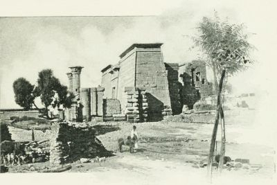 AN EGYPTIAN TEMPLE.
II. Boundaries and Dimensions. On the north, Egypt is bounded by the Mediterranean Sea; on the east, by Palestine, the Arabian Desert, and the Red Sea; on the south, by Nubia; and on the west, by the great African Desert. Its limits have been the same in nearly all ages. In a geographical sense, it embraces 115,000 square miles; but of this more than nine-tenths consists of uninhabitable deserts. The true Egypt, the home of its people, is simply the Valley of the Nile and the space between its mouths, an area of 9,600 square miles, a little larger than the State of New Hampshire. Deducting from this the area covered by the Nile and its branches, the land of Egypt which may be occupied or cultivated includes about 5,600 square miles, or less than the united area of Connecticut and Rhode Island.
III. Divisions. There have always been two Egypts, Northern and Southern. Northern or Lower Egypt comprises the Delta of the Nile, triangular in shape, a plain between the eastern or Pelusiac branch of the Nile and its western or Canopic branch. This is a vast garden, with soil the richest in the Old World, and the grain field of the Roman empire. Southeast of the Pelusiac branch lay the Land of Goshen (now Esh Shurkiyeh), the home of the Israelites during the Sojourn. Southern or Upper Egypt is a narrow valley, winding with the course of the Nile, varying in width from two to ten miles; a strip of fertile soil between two barren hills, beyond which the desert lies on either side. The two sections were always regarded as separate, and each was represented in the double crown worn by the kings. There was another division, made in very early times, into nomes, or provinces, each having its own ruler, and its own object of worship. Of these nomes there were from 36 to 50 at different times.
IV. The Nile. This has been in every age the most important feature in the topography of the country, and the cause of its surpassing fertility. Its sources, long unknown, are in the great lakes of Central Africa, whence it flows in a northerly direction. The main stream, called the White Nile, receives in Nubia its principal tributary, the Blue Nile, which rises in Abyssinia. During the last 1,500 miles of its course it is not increased by any other stream, and flows through a torrid desert. Yet, as it enters the Mediterranean, its current is still that of a mighty river. Its mouths are at present three in number, though formerly seven; and, from their resemblance on the map to the Greek letter Δ, that portion of Egypt is called the Delta. Its annual overflow begins, in Lower Egypt, about the 25th of June, attains its height in three months, and remains stationary twelve days, at a height of about 36 feet above its ordinary level at Thebes, 25 feet at Cairo, and 4 feet at its mouth. This overflow is due to the rains in Central Africa, and as it brings down new soil, keeps the land always fertile. But for the Nile, Egypt would only be a part of the Great Desert.
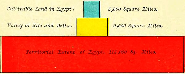 AREA OF EGYPT.
V. The People of Egypt were of the Hamitic stock, a race of high capacity, forming the earliest civilization known in history. They were religious, but worshiping[42] animals, and even the lowest forms of life; contemplative and studious, attaining to considerable knowledge, though on narrow lines of research; patriotic, but not fond of war, and therefore rarely conquerors of other nations. Their language was "agglutinative monosyllabic," with mingled Nigritic and Semitic characteristics. Their government was most thoroughly organized, and took cognizance of even the minute matters of life. Their art was massive and sombre, imposing from its vastness, but not varied, and therefore giving but little play to genius. The Egyptians were slender of frame, but strong. Their faces were oval and olive-colored; their hair long, crisp and jet-black. They are supposed to be represented at the present time by the Copts.
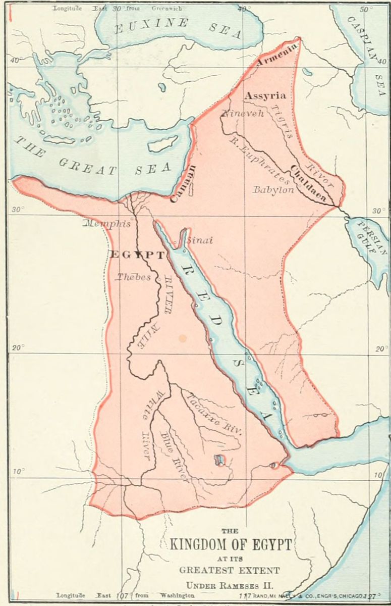
VI. The History of Egypt begins at a time undated, but long after the flood. It is divided into three periods, those of the Old, Middle, and New Empires. The Old Empire was founded by Menes, and had its capital at Memphis. During the fourth dynasty of this period the Pyramids were built. The Middle Empire arose at Thebes, and lasted until 1570 B.C. The Twelfth dynasty was most powerful during this epoch, conquering Ethiopia and Arabia. About 2000 B.C. the land was conquered by foreign princes, who ruled 400 years, and were known as the Hyksos, or Shepherd Kings. The New Empire arose in 1570 B.C., after the expulsion of the Hyksos, and lasted for a thousand years. Its greatest monarch was Rameses II., who has been supposed to be the "Pharaoh of the Oppression" (not of the Exodus), and ruled as far east as Chaldea and Assyria. The above dates are all uncertain. Concerning the chronology, see page 13. The land was conquered by the Persians, B.C. 527, and annexed to the Persian empire.
VII. The principal Places were, in Lower Egypt, Memphis, the ancient capital; Heliopolis, called in the Bible On, near the eastern branch of the Delta; Rameses, in the Land of Goshen; Pelusium, at the eastern mouth of the Nile; and Alexandria, in later history the metropolis of Egypt, near the Canopic mouth of the Nile. In Upper Egypt, Thebes was the most important place, and long the capital.
OUTLINE FOR REVIEW.
1. Names. Egypt, Kem, Mizraim, Rahab, Land of Ham.
2. Boundaries and Dimensions. North (Mediterranean Sea); East (Palestine, Arabia, Red Sea); South (Nubia); West (African Desert). Area, 115,000 square miles. Inhabitable, 9,600 square miles. Land, 5,600 square miles.
3. Divisions. Lower (Delta); Upper (Valley).
4. Nile. White Nile, Blue Nile; Sources; Delta; Overflow.
5. People. Hamitic Origin; Civilization; Language; Art; Physical Traits.
6. History. Old Empire (Memphis, Pyramids); Middle Empire (Thebes, Dynasty XII., Hyksos); New Empire (Rameses II., Persians).
THE WILDERNESS OF THE WANDERING.
I. Situation. This region lies between Egypt and Edom, a great triangle, having for its three points the border of Lake Menzaleh, the southern extremity of the Dead Sea, and Ras Mohammed, the southern end of the peninsula. Its northern boundary is the Mediterranean Sea, the land of the Philistines, and the Negeb, or South Country. Its southeastern line is the depression of the Arabah, and the Gulf of Akaba, or Ælanitic Gulf. Its southwestern line is the Isthmus of Suez and the Gulf of Suez. From Egypt, in a line due east, to the Dead Sea, is about 200 miles; from the Mediterranean, at the Wady el Arish ("the River of Egypt"), to Ras Mohammed, a line a little east of south, is about 225 miles, thus making the entire area of the triangle about 22,500[43] square miles, or less than the aggregate area of New Hampshire, Vermont and Massachusetts, though larger than any two of those States.
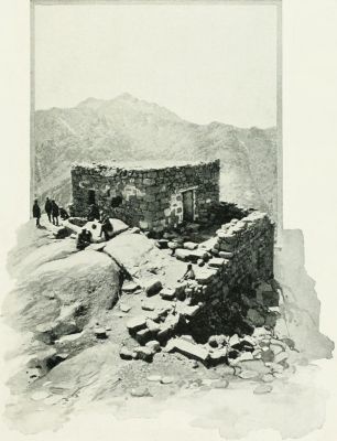 RÂS ES SUFSAFEH (MOUNT SINAI).
II. Natural Features. This region has two general divisions, and three others closely connected with them. 1. The Table-Land. 2. The Sinaitic Mountains. 3. The narrow plain by the western arm of the Red Sea. 4. The Arabah, or valley between the Ælanitic Gulf and the Dead Sea. 5. The Negeb, or South Country.
1. The northern and central portion of the triangle is a sterile table-land of limestone, from 2,000 to 2,500 feet high, and consisting of rolling plains with a gravelly surface; with few springs, and these mostly of impure water; and watered only by the streams of the Wady el Arish ("the River of Egypt"), a torrent which is dry during most of the year.
This was the Wilderness of Paran, "the great and terrible wilderness" (Deut. 1:19) in which the Israelites wandered for 38 years. It is now called et Tih, "the wandering," and is traversed from east to west by two caravan routes, marked by the bleached bones of camels that have perished by the way. On the north it slopes away to a plain of white sand reaching to the Mediterranean, which was generally called the Wilderness of Shur. On the other three sides it is bounded by a chain of mountains, 4,000 feet high, called Jebel et Tih. It was in this wilderness country that the children of Israel were doomed to wander until all the generation that came out of Egypt died, except Caleb and Joshua. Even Moses was not permitted to more than see the Promised Land from the top of Pisgah.
2. Beyond the desert, and separated from it by the chain of mountains above named, and also by a narrow strip of sand south of the mountains, is the group of the Sinaitic Mountains. This group is triangular in form, and consists of ranges radiating from a centre. The names Horeb and Sinai seem to have been used interchangeably, though some consider the former the name of the group, and Sinai a single peak. There has been much discussion as to which is the "Mountain of the Law," from which the Ten Commandments were given. Three peaks have been most prominently presented by different explorers. Jebel Musa, "the Mountain of Moses," which is supported by local tradition, and by the authority of Ritter, Kurtz, Keil and Kalisch; Jebel Serbal, claimed by Lepsius; and Râs es Sufsafeh, supported by Robinson, Dean Stanley, and the most of recent travelers. This is a granite cliff standing above the plain so boldly that one may walk up and lay a hand upon its wall, which rises 1,500 feet above the plain, and 6,500 feet above the sea. The plain in front of it is called er Rahah, and is 2,300 yards long and 900 yards wide, sufficiently large for the presence of all the Israelites before the mount, without including another plain on the northeast, branching from er Rahah, and called Wady esh Sheikh. It is situated in a vast and dreary desert, occupied for the most part by hordes of Arabs, who subsist by plunder, and render the journey to Sinai impossible except to large and well defended caravans.
3. Between the mountains and the western arm of the Red Sea lies a narrow plain, following the line of the coast. On the northwestern section it was called the Wilderness of Etham; opposite the Sinaitic group of mountains, the Wilderness of Sin. This lower portion is now called el Kaa.
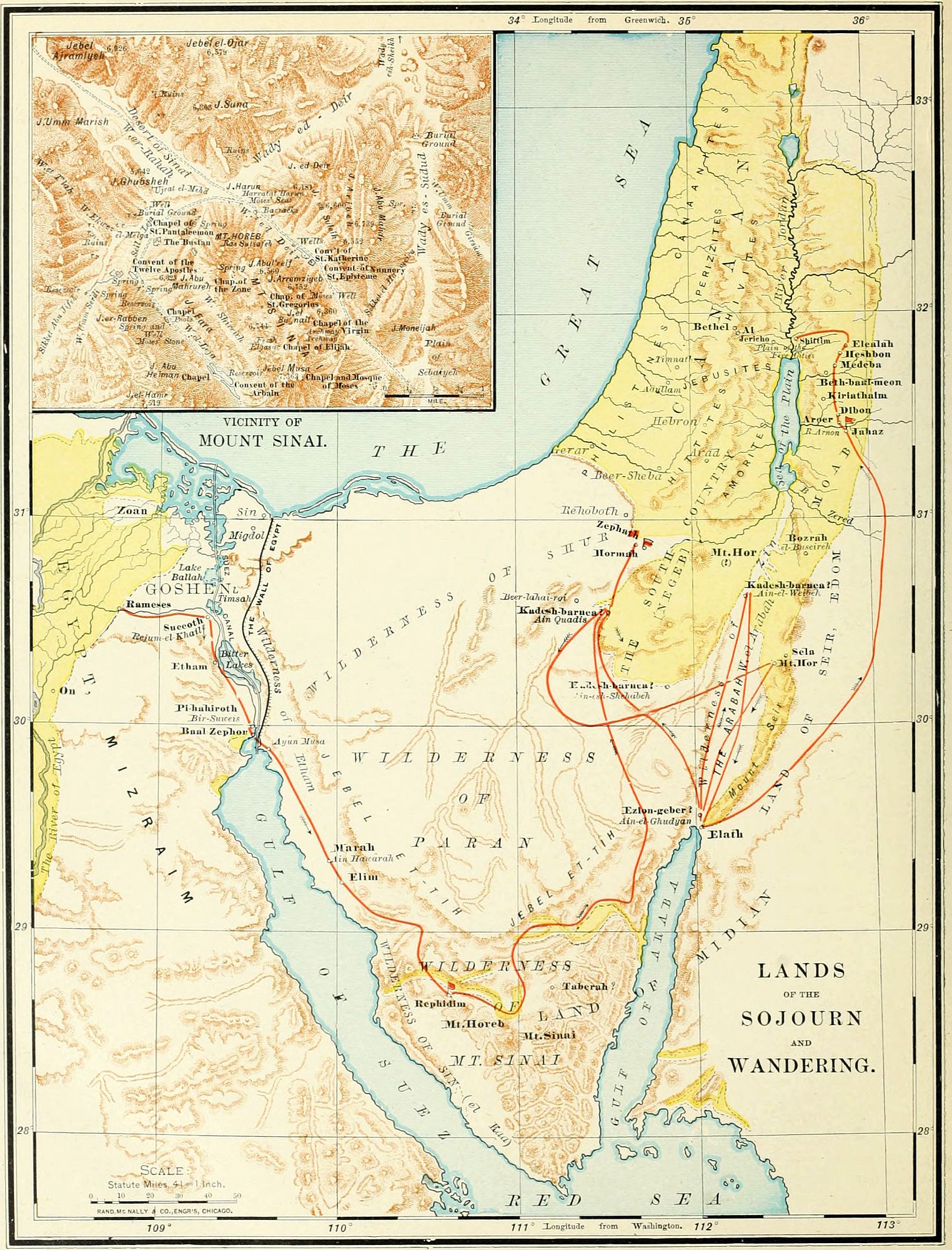
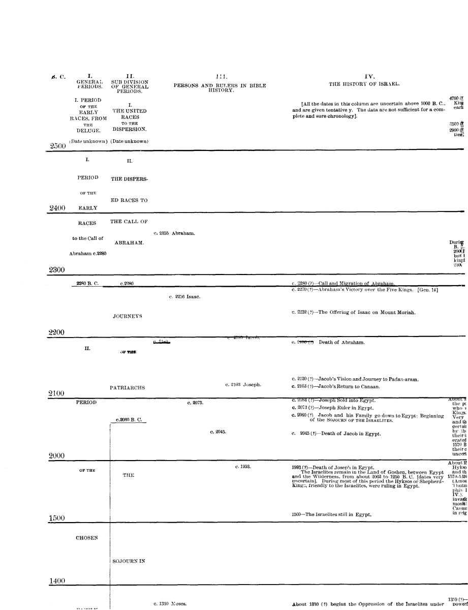
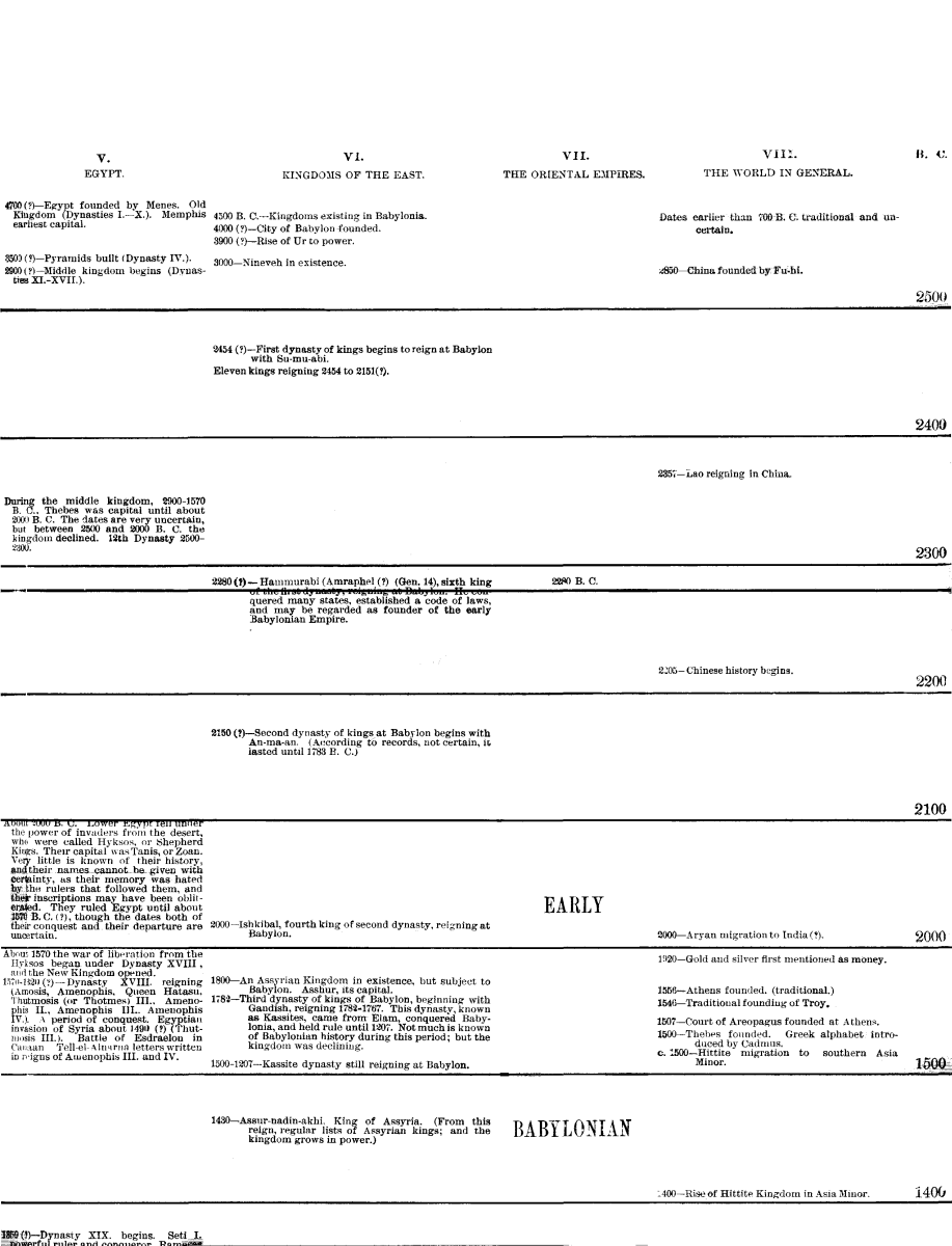
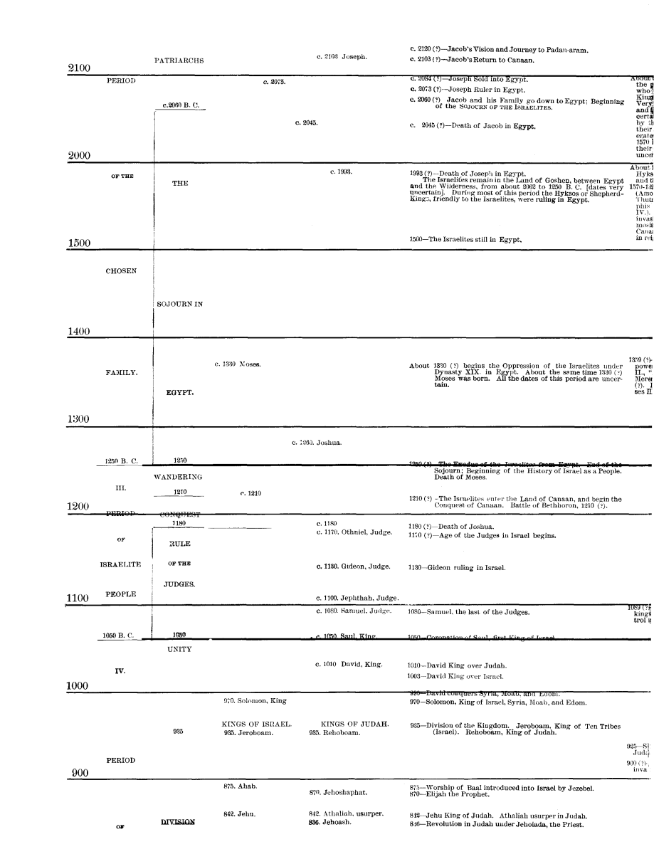
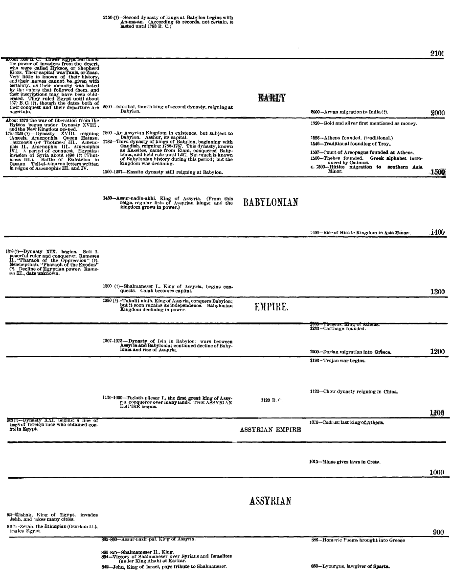
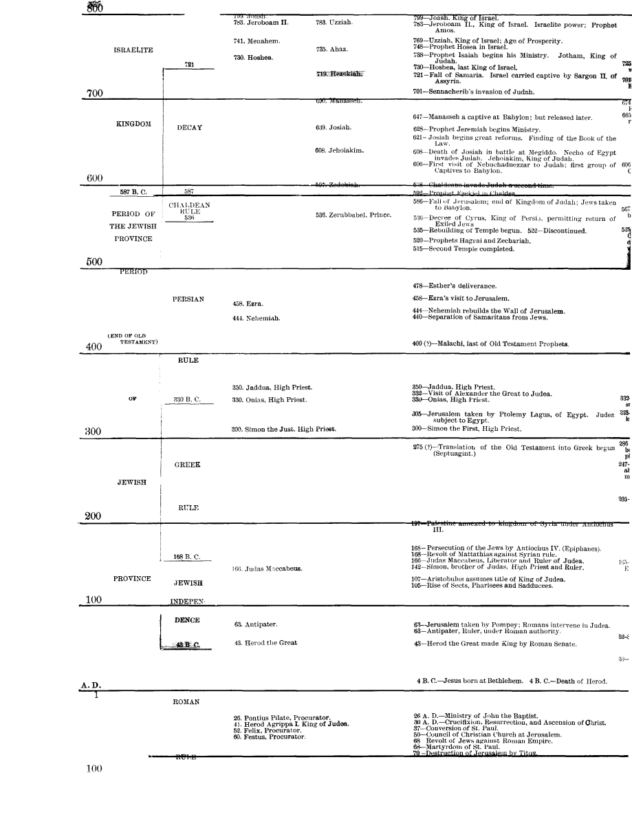
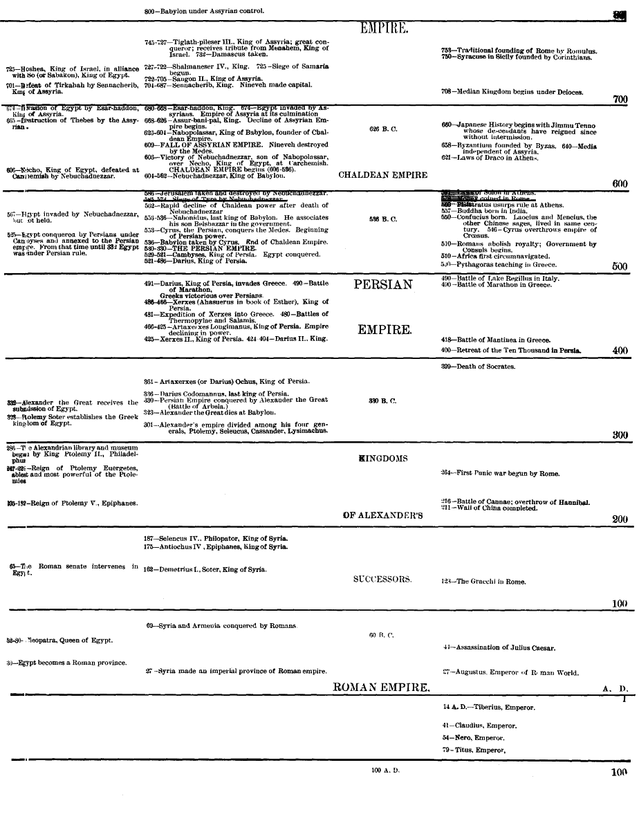
4. From the head of the Gulf of Akaba (Ælanitic Gulf) a gorge extends nearly northward to the Dead Sea, an extension of the Jordan Valley, the Arabah, called in the history the Wilderness of Zin. It lies between the mountain chain on the east of the Wilderness of Paran (et Tih) and Mount Seir, the home of the Edomites. The opinion held by many early writers, that the Jordan[45] once flowed through this depression into the Red Sea, may be correct as regards a past geologic period, but not as an historical fact; for it is evident that no great change has taken place in this region within the limit of historical time. Opposite the traditional Mount Hor the bed of the valley is about 500 feet above the sea-level; and from this point it slopes northward to the Dead Sea, 1,300 feet below the sea-level, and southward to the Gulf of Akaba.
5. The Negeb, or South Country, has already been described. (See p. 32.) The southern section of this region belongs to the Wilderness of the Wandering, from Mount Halak northward.
III. Inhabitants. The only inhabitants of this region at the time of the Israelite Wandering were the Amalekites, who roamed throughout the desert of Paran. Their origin is uncertain; and they may have belonged to the same stock with the earliest inhabitants of Canaan, as they were a distinct tribe in the times of Abraham. (Gen. 14.) They were the bitter enemies of Israel during all the period of the Wandering, attacking their rear, and destroying detached companies of them on their march. (Deut. 25:18.) The only pitched battle with them took place at Rephidim, near Mount Sinai, when they were defeated by Israel; but they attacked the Israelites again at Hormah, and inflicted serious injury. Long afterward their power was broken by Saul (1 Sam. 15), and their destruction was completed by David. (1 Sam. 27 and 30.)
OUTLINE FOR REVIEW.
I. Situation. Triangle (Menzaleh, Dead Sea, Ras Mohammed). Boundaries. North (Mediterranean Sea, Philistines, Negeb); Southeast (Arabah, Akaba); Southwest (Isthmus and Gulf of Suez). 200 miles east and west; 225 north and south.
II. Natural Features. Table-Land (Paran, Shur); Sinaitic Mountains (Horeb and Sinai); Plain (Etham, Sin); Arabah (Zin); Negeb (Mount Halak).
III. Inhabitants. Amalekites (Rephidim, Hormah).
THE LAND OF EDOM.
I. Boundaries. The country of Edom, or of the Edomites, lay south of that of the Moabites, the boundary between them being the brook Zered (Wady el Ahsy), which flows into the southern lagoon of the Dead Sea. On the east it extended to the great Arabian desert, in that section supposed to be the "land of the Temanites." On the south its border was the country of the Midianites, and the head of the Gulf of Akaba. The western boundary was the Arabah, or sunken ravine running northward between the Red Sea and the Dead Sea. There is, however, an opinion gaining ground, that "the field of Edom" extended somewhat to the west of the Arabah, and south of Palestine.
II. Names. The earliest name of this country, and one often used throughout Bible history, was Mount Seir, "the rugged," from its rough, mountainous nature. This was the name of its earliest inhabitants, "the sons of Seir the Horite." (Gen. 36:20.) Afterward it was possessed by the descendants of Esau, and called Edom, "red," from the "red pottage" for which Esau sold his birthright. Probably the red color of its sandstone mountains also aided to fix the name. In the New Testament time the word received a Greek form, and became Idumea. Josephus called it Geballene, "mountainous." At present it is divided into two sections, each having a different name; north of Petra being called Jebal, and south, esh Sherah.
III. Natural Features. Edom is emphatically a land of mountains. On the west, along the side of the Arabah, is a line of low limestone hills. Back of these rise higher, igneous rocks, surmounted by variegated sandstone, of peculiar color, 2,000 feet high. The eastern side of the mountains slopes gently away into the Arabian desert. But, though rough, the land is rich, and the terraced hill-sides have in all ages been bright with vegetation, and its people have been prosperous. So the blessing of Esau (Gen. 27:39, 40) has been fulfilled in a land of "the fatness of the earth, and of the dew of heaven." Its capital during the Old Testament period was Bozrah (now Busireh), near its northern border. Afterward, Sela, the Petra of remarkable rock-hewn buildings, arose to prominence. Ezion-geber, at the head of the Gulf of Akaba, was its seaport.
IV. History. Mount Seir was first settled by the Horites, or Horim, like the inhabitants of Palestine a people of unknown origin. During the later patriarchal age it was conquered and possessed by Esau, the brother of Jacob, and ever after occupied by his descendants, the Edomites. The refusal of this people to allow the Israelites to journey through their territory compelled them to make a long detour around Edom on the south and east, and enter Palestine by the land of the Moabites. During the period of the Judges the Edomites are not mentioned; but they were beaten by Saul, and thoroughly conquered by David, after a severe struggle. At the division of the kingdom, B.C. 935, Edom was held by Judah. Its people rebelled in the time of Jehoram, the son of Jehoshaphat, and, although defeated by Judah, were able to maintain their independence. They joined the Chaldeans under Nebuchadnezzar in the destruction of Jerusalem, for which the later prophecies and psalms gave them bitter denunciations. About the time of the captivity, B.C. 587-536, the Edomites gained possession of most of the country south of Judah, extending even to the confines of Egypt. But they lost their own land, Mount Seir, which became the possession of the Nabatheans. These were a race, perhaps allied to the Arabians, who laid aside their nomad habits, and founded a kingdom, whose people grew rich by the caravan trade. The Edomites, or Idumeans, south of Palestine, were conquered by the Maccabean princes and incorporated with the Jews, B.C. 130, and the Nabathean kingdom was annexed to the Roman empire, A.D. 105.
V. Peculiarities. The Edomites, though descended from the stock of Abraham, adopted the idolatry of the Canaanites, with whom they had intermarried. But[46] their most remarkable feature, as a nation, was that of dwelling in caves. The mountains of Idumea are of soft sandstone, easily wrought, and are penetrated with caves and grottoes, which were used, not like those of other nations, for burial places, but for residence. The rock-hewn temples, palaces and homes of Petra, so well known to travelers, are magnificent in appearance. The custom probably arose from the fear of robbers, and from the ease with which the caves could be excavated in the sandstone rock.
OUTLINE FOR REVIEW.
1. Boundaries. Moab; Desert: Midianites; Arabah.
2. Names. Seir, Edom, Idumea, Geballene, Jebal and esh Sherah.
3. Natural Features. Mountains; Soil; Capitals (Bozrah, Petra).
4. History. Horites; Esau; Edomites; Israelite Supremacy; Chaldeans; Nabatheans; Maccabeans; Romans.
5. Peculiarities. Religion; Rock Houses.
THE WANDERING IN THE WILDERNESS.
There are great difficulties in fixing the location of the places and the order of events in the history of the forty years which intervened between the exodus, or "going out," from Egypt, and the entrance into the Promised Land (B.C. 1250-1210). These difficulties arise from various causes: the antiquity of the events, the fragmentary character of the history, the extent of the country, our scanty knowledge of the region, and especially the changes which have taken place in the sea-coast during the 3,000 years past. While the general course of the journey can be easily defined, the particular localities are, in many instances, exceedingly uncertain. For the convenience of the student, we divide the entire journey from Egypt to Canaan into sections.
I. From Rameses to the Red Sea. (Exod. 12-14; Num. 33:5-8.) The sojourn of the Israelites was passed in the Land of Goshen, between the Nile and the Isthmus of Suez. The court of the reigning Pharaoh during the time while Moses was negotiating for the departure of the Israelites, was at Zoan, or Tanis (Psa. 78:12), the royal city of the Delta. Rameses, the place of meeting for the Israelites, was probably a district rather than a city (Gen. 47:8), but may have been at Abu Kesheib. Pithom (Exod. 1:11) has been discovered at Tell Maskutor, ten miles west of Lake Timsah. Succoth, "booths" or "tents," was probably not a city but a camp, and its location is unknown. Etham, "wall" (Exod. 13:20), may indicate a place near the great wall which extended across the isthmus. Pi-hahiroth may be at Agrud, near Suez. Baal-zephon may be the mountain Jebel Alaka. The Israelites crossed the sea at the narrow Strait of Suez, where the distance from shore to shore is about two-thirds of a mile. At that time the gulf probably extended several miles north of its present position. The northeast wind drove out the waters, leaving a path across the gulf, with pools on either side, as a "wall" or defense to the crossing Israelites.
II. From the Red Sea to Mount Sinai. (Exod. 15-19; Num. 33:8-15.) The general direction can be traced with certainty, but the precise places of encampment are only conjectural. It is probable that so vast a body of people, about two millions, must have occupied a large extent of territory, and the "stations" were the various headquarters of the camp. This section of the journey was mostly spent in the two narrow plains along the coast, the Wilderness (or desert) of Etham, and that of Sin. At Marah (Ain Hawârah) the bitter waters were healed; at Elim (Wady Ghurundel) they were refreshed by the "twelve wells and three-score and ten palm trees." At the next station, No. 9, "the encampment at the Red Sea," they saw for the last time the waters of the western gulf, and the land of Egypt beyond them. Here they turned eastward, and, passing the mountain barrier, entered the Wilderness of Sin. (This is to be distinguished from the Wilderness of Zin, or the Arabah, on the eastern side of the peninsula.) In this wild and barren country, food failed them, and the manna began to be supplied (Exod. 16), to last for forty years. Their general course was now eastward, through the wadies, or dry beds of winter torrents. At Rephidim (station 13) two events are recorded as occurring. The want of water led to a miraculous supply from the smitten rock (Exod. 17:2-7); and the Israelites fought the first battle in their history, with the wandering Amalekites, who attacked the rear of the scattered host. Under Joshua, who here appears for the first time, they were defeated, and devoted to complete destruction. (Exod. 17:8-16; Deut. 25:18.) The next station was Mount Sinai, in front of which they encamped, probably on the plain er Rahah. Their journey thus far had occupied two months and a half, and here they remained for a year. The principal events at Mount Sinai were: 1. The giving of the law. (Exod. 19-31.) 2. The worship of the golden calf, and its punishment. (Exod. 32.) 3. The building and consecration of the Tabernacle. (Exod. 35-40.) 4. The numbering and organization of the people. (Num. 1-2.)
III. From Mount Sinai to Kadesh-barnea. After a year spent at and around Mount Sinai, the camp was taken up, and the host, led by the Ark of the Covenant, entered once more upon its march. The direction of the journey was northeast, and the route was probably through the Wady Saal. At Taberah (station 15), the "fire of the Lord" consumed some on the verge of the camp who murmured against God's commands. (Num. 11:1-3.) At Kibroth-hattaavah (station 16), (perhaps the same place with the preceding), a dislike of the manna and a lust for flesh-meat seized the crowd of people, and for a month they fed upon quails, but were punished by a plague, which destroyed multitudes, and gave a name to the place, "the graves of lust." (Num. 11:4-35.) At Hazeroth (probably Ain Hudherah), Miriam instigated Aaron to a rebellion against Moses, but was smitten with leprosy, though healed at the prayer of Moses. (Num. 12:1-16.) The Israelites followed the mountain chain by the Red Sea, keeping upon the western side of the hills, and, passing through the edge of the Wilderness of[47] Paran and along the Arabah, followed up the line of the "Mount of the Amorites" (which appears to have been a general name for the mountains in the southern portion of the Negeb, or South Country), until they came to Kadesh-barnea. The location of this place is the great difficulty in the geography of the period. The name appears to be used with reference to a region, and more definitely referring to a place. Three localities have been claimed, all on the border of the "Mount of the Amorites," or the South Country. The most southerly location is that now known as Ain esh Shehabeh, on theWady Jerafeh; the most westerly, at Ain Gadis, or Quadis, directly south of the land of Judah; the one farthest to the north and east, at Ain el Weibeh, in the edge of the Arabah, south of the Dead Sea. The latter has been regarded by most explorers since Dr. Robinson, as the correct site, and as it appears on the older maps. But the Rev. J. Rowlands, on a journey through the entire region, identified Ain Quadis as the true Kadesh-barnea, and his conclusion was confirmed by Dr. H. C. Trumbull after a thorough investigation of all the three places. It is now accepted by most writers. We have therefore regarded Ain Quadis as Kadesh-barnea, and have made it the center of Israelite journeying during the thirty-eight years of the wandering. The change in the location of Kadesh-barnea may necessitate a change in the location of Mount Hor, which Trumbull places at Jebel Maderah, but we have retained the old locality on the edge of Edom. Twice the Israelites were encamped at Kadesh, which marked the beginning and end of the thirty-eight years' wandering in the Wilderness of Paran. From Kadesh the twelve spies were sent northward into the Land of Canaan, and the adverse report of ten of them caused such terror and rebellion in the host, that God declared that they should not enter the Promised Land until all that generation should have passed away. (Num. 13, 14.) They were ordered to turn back into the wilderness, but disobeyed, and, against their leaders' advice, undertook to force a passage to Canaan, probably up the pass es Sufa. But the inhabitants of the mountains (Amorites, Canaanites, and Amalekites in alliance) attacked them to their utter defeat at Hormah, and effectually barred their entrance to the land through the South Country, as the warlike Philistines had closed it against them by the way of the plain by the sea. (Exod. 13:17.) Discouraged and despairing, the host of Israel again turned their faces once more toward the terrible Wilderness of Paran.
IV., V., VI. From Kadesh-barnea to Mount Hor, Ezion-geber, and Return. The period of the next thirty-eight years remains in shadow. Scarcely an event is named which certainly belongs to this division, the longest by far in the journey. In the history at Num. 14:45, there is a break in the record, and other topics are referred to until we find the people at Kadesh once more, at the end of the 38 years, in chapter 20; and the list of stations in Num. 33:18-36, is only a barren catalogue of 18 places, in which not one is clearly recognized, and only two or three can be even guessed at. Some have thought that the entire period was spent in the Arabah, wandering up and down, as two of the stations plainly belong there. But it is more probable that the people wandered over the borders between the Negeb (South Country) and the Wilderness of Paran. For convenience we may subdivide this period of wandering into its three journeys. From Kadesh, through 12 unknown stations, to Moseroth, which is afterward named in the account of Aaron's death (Deut. 10:6), showing that it was near Mount Hor. This is indicated on the Map as Journey IV. Journey V. was from Mount Hor down the Arabah southward to Ezion-geber, at the head of the Ælanitic Gulf. Journey VI. was once more through the Arabah, northward to Kadesh-barnea, completing the period of the punishment for the rebellion of 38 years before. Here three events took place. 1. The rock was smitten by Moses, when God had bidden him speak to it, in order to bring forth water; and, as a penalty, he was not permitted to enter Canaan. (Num. 20:1-13.) 2. The Israelites asked of the Edomites (on whose western border they were encamped at Kadesh), the privilege of crossing their territory on their journey to Canaan, but their request was denied. 3. Soon after this, the king of the Canaanite city of Arad, in the Negeb, or South Country, 20 miles south of Hebron, hearing of Israel's approach by the same route as that of the spies, 38 years before, went out to meet the invading host. He was repulsed near the same place where Israel had suffered a defeat before, and which was thenceforth called Hormah, "destruction." (Num. 21:1-3.)
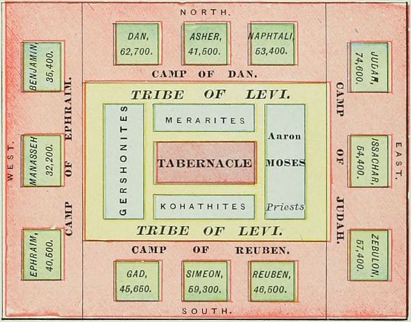 CAMP OF ISRAEL.
VII., VIII. From Kadesh-barnea to Elath and Jordan. The Israelites were now ready to enter their Land of Promise. But, as the entrance by the south was found impracticable, and the Edomites would not permit them to cross their mountains, a long detour became necessary; so for a third time they took their[48] journey through the Arabah. This we have indicated on the map as No. VII. They paused before Mount Hor, while Aaron left them, to ascend the mountain and to die. The peak still bears his name, Jebel Haroun. So according to most travelers; but Trumbull locates Mount Hor in the Negeb. At Ezion-geber and Elath (stations 43 and 44), they saw once more the Red Sea, at its eastern arm. On this journey, too, but whether before or after passing the Red Sea, is uncertain, they were plagued by serpents, and "the brazen serpent" was lifted up by Moses. (Num. 21:4-9.) At last the southern point of Mount Seir was reached and passed, and now for the last time (Journey VIII.) the Israelites turned their faces northward. They traveled through the land of Teman, between Edom and the Arabian desert. At the brook Zered (Wady el Ahsy), station 49, they entered the land of Moab, which they crossed in safety (Num. 21:11); and at the brook Arnon they came into the country of Sihon, the king of the Amorites, who came against them, and was defeated and slain at Jahaz. (Num. 21:12-31.) The Amorites of Bashan on the north were ruled by the giant Og, a descendant of the ancient Rephaim. (See page 37.) His land was conquered and himself slain in a decisive battle at Edrei. From the heights of Abarim (station 57) they descended to the Jordan Valley, and encamped at their last station (No. 58) before entering the Land of Promise, on the eastern bank of the Jordan, opposite Jericho. Here occurred: 1. The episode of Balaam's prophecy. (Num. 22-24.) 2. The iniquity of Israel with the women of Moab, and the plague on the people as a result. (Num. 25:1-18.) 3. The numbering of Israel. (Num. 26.) 4. The campaigns against the Moabites and Midianites. (Num. 31.) 5. The allotment to the tribes of Reuben and Gad, and half the tribe of Manasseh. (Num. 32.) 6. The repetition of the law and the recapitulation of the journeys, in the book of Deuteronomy. 7. Last of all, the ascent of Moses up the height of Nebo, his prophetic view of the Promised Land, and his lonely death. (Deut. 34.)
 KADESH-BARNEA AND VICINITY.
(According to Dr. Trumbull.)
STATIONS OF THE ISRAELITES DURING THEIR JOURNEY FROM EGYPT TO CANAAN.
I. From Rameses to the Red Sea. | ||||
| Station. | Identification. | Exod. | Num. | Deut. |
| 1. Rameses | Abu Kesheib | 12:37 | 33: 3 | |
| 2. Succoth | Unknown | 12:37 | 33: 5 | |
| 3. Etham | Unknown | 13:20 | 33: 6 | |
| 4. Pi-hahiroth | Bir Suweis | 14: 2 | 33: 7 | |
| 5. Red Sea | 14:22 | 33: 8 | ||
II. From the Red Sea to Mount Sinai. | ||||
| Station. | Identification. | Exod. | Num. | Deut. |
| 6. Desert of Shur, or of Etham | Shore of Red Sea | 15:22 | 33: 8 | |
| 7. Marah | Ain Hawârah | 15:23 | 33: 8 | |
| 8. Elim | Wady Ghurundel | 15:27 | 33: 9 | |
| 9. Red Sea | Wady Taiyibeh | 33:10 | ||
| 10. Desert of Sin | El Murkîyeh(?) | 16: 1 | 33:11 | |
| 11. Dophkah | Ain Markhâ(?) | 33:12 | ||
| 12. Alush | Uncertain | 33:13 | ||
| 13. Rephidim | Wady Feiran | 17: 1 | 33:14 | |
| 14. Sinai | Plain er Râhah | 19: 1 | 33:15 | |
III. From Mount Sinai to Kadesh-barnea. | ||||
| Station. | Identification. | Num. | Num. | Deut. |
| 15. Taberah | Wady Sâal(?) | 11: 3 | 9:22 | |
| 16. Kibroth-hattaavah | Erweis el Ebeirig | 11:34 | 33:16 | |
| 17. Hazeroth | Ain Hudherah | 11:35 | 33:17 | |
| 18. Mount of the Amorites | Jebel Magrah(?) | 1:19 | ||
| 19. Kadesh-barnea | Ain el Weibeh(?) | 13:26 | 1:19 | |
IV. From Kadesh-barnea to Mount Hor. | ||||
| Station. | Identification. | Num. | Num. | Deut. |
| 20. Rithmah | Uncertain | 33:18 | ||
| 21. Rimmon-parez | Uncertain | 33:19 | ||
| 22. Libnah | Uncertain | 33:20 | ||
| 23. Rissah | Uncertain | 33:21 | ||
| 24. Kehelathah | Uncertain | 33:22 | ||
| 25. Mount Shapher | Jebel Araif(?) | 33:23 | ||
| 26. Haradah | Uncertain | 33:24 | ||
| 27. Makheloth | Uncertain | 33:25 | ||
| 28. Tahath | Uncertain | 33:26 | ||
| 29. Tarah | Uncertain | 33:27 | ||
| 30. Mithcah | Uncertain | 33:28 | ||
| 31. Hashmonah | Uncertain | 33:29 | ||
| 32. Moseroth | Mount Hor | 33:30 | ||
V. From Mount Hor to Ezion-geber. | ||||
| Station. | Identification. | Num. | Num. | Deut. |
| 33. Bene-jaakan | Arabah | 33:31 | ||
| 34. Hor-hagidgad | Wady Ghudhaghidh | 33:32 | ||
| 35. Jotbathah | Emshâsh(?) | 33:33 | ||
| 36. Ebronah | Uncertain | 33:34 | ||
| 37. Ezion-geber | Gulf of Akabah | 33:35 | ||
| [49] | ||||
VI. From Ezion-geber to Kadesh-barnea. | ||||
| Station. | Identification. | Num. | Num. | Deut. |
| 38. Kadesh-barnea | Ain Quadis | 20: 1 | 33:36 | |
VII. From Kadesh-barnea to Elath. | ||||
| Station. | Identification. | Num. | Num. | Deut. |
| 39. Bene-jaakan | Arabah | 10: 6 | ||
| 40. Mosera | Mount Hor | 20:22 | 33:37 | 10: 6 |
| 41. Gudgodah | Wady Ghudhaghidh | 10: 7 | ||
| 42. Jotbath | Uncertain | 10: 7 | ||
| 43. Ezion-geber | Gulf of Akaba | 21: 4 | 2: 8 | |
| 44. Elath | Akabah | 2: 8 | ||
VIII. From Elath to Jordan. | ||||
| Station. | Identification. | Num. | Num. | Deut. |
| 45. Zalmonah | Wady Amran(?) | 33:41 | ||
| 46. Punon | Uncertain | 33:42 | ||
| 47. Oboth | Uncertain | 21:10 | 33:43 | |
| 48. Ije-abarim | Uncertain | 21:11 | 33:44 | |
| 49. Zered | Wady el Ahsy | 21:12 | 10:13 | |
| 50. Arnon | Wady Môjeb | 21:13 | 10:24 | |
| 51. Dibon-gad | Dhibân | 33:45 | ||
| 52. Almon-diblathaim | Uncertain | 33:46 | ||
| 53. Beer | Uncertain | 21:16 | ||
| 54. Mattanah | Uncertain | 21:18 | ||
| 55. Nahaliel | Uncertain | 21:19 | ||
| 56. Bamoth | Uncertain | 21:19 | ||
| 57. Abarim, Nebo, or Pisgah | Jebel Neba | 21:20 | 33:47 | |
| 58. Plains of Moab, or Jordan | Ghôr en Nimrîn | 22: 1 | 33:48 | |
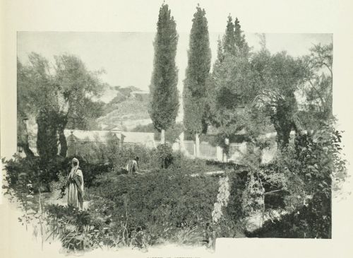 GARDEN OF GETHSEMANE.
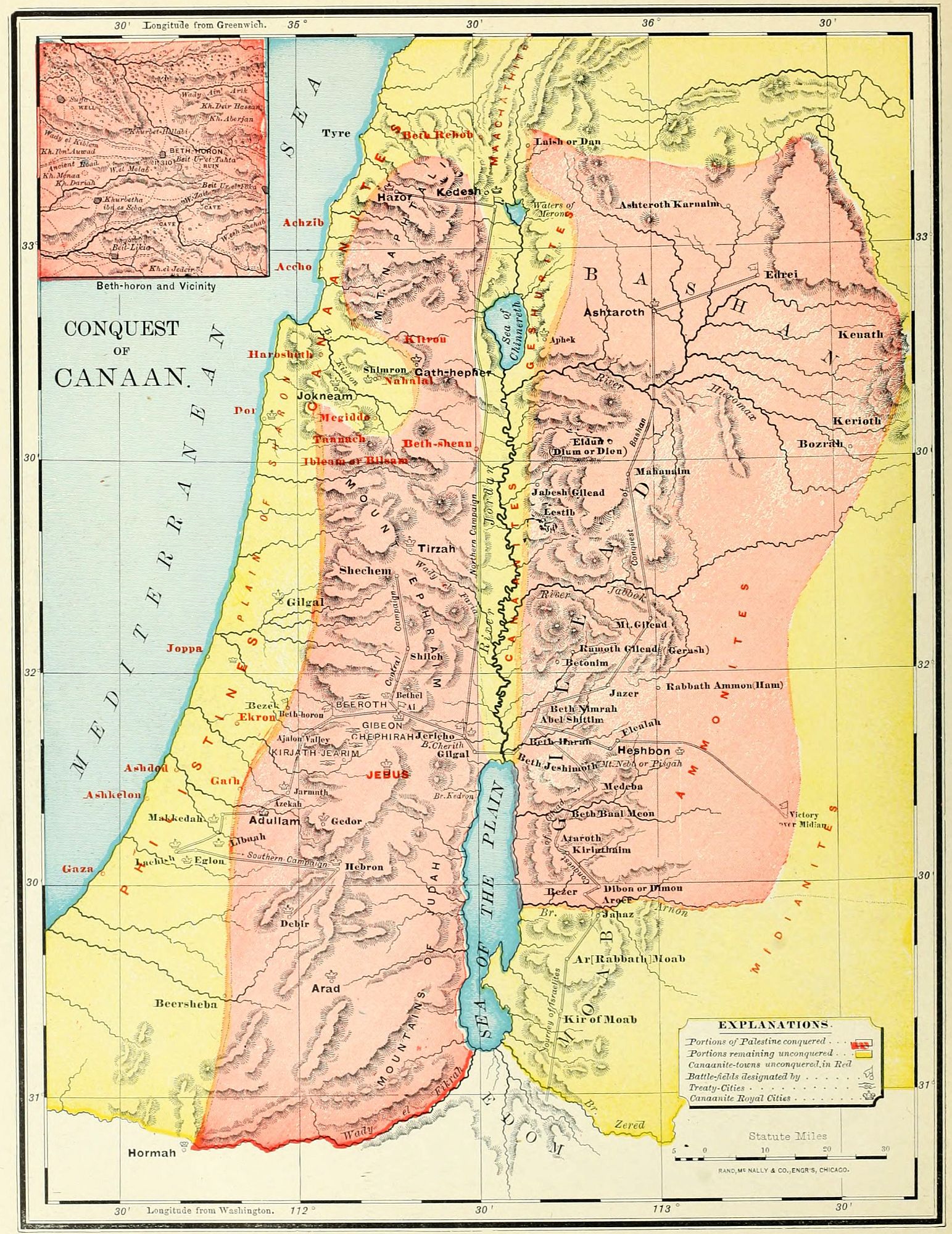
THE CONQUEST OF CANAAN.
After the forty years of the Wandering came the seven years of the Conquest. Yet it is true, that in the complete sense the conquest began before the Israelites crossed the Jordan under Joshua, and was not finished until long after the period of the Judges. As Dean Stanley says: "The conquest began from the passage of the brook Zered, under Moses; it was not finally closed till the capture of Jerusalem by David. But in a more limited sense it may be confined to the period during which the territory, afterward known by the name of Palestine, was definitively occupied as their own by the Israelites." The map on page 36 shows us the territorial divisions of the land before the conquest; the one which we are now studying presents the campaigns by which it was won. These may be divided into three sections. 1. The conquest of the territory on the east of the Jordan, in three campaigns, during the rule of Moses. 2. The conquest of that on the west of the Jordan, under the leadership of Joshua, in three campaigns. 3. A series of supplementary conquests completing the work of subjugation.
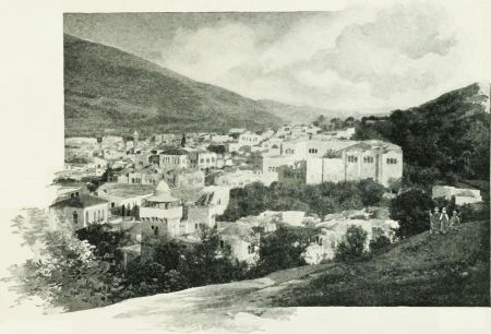 SHECHEM.
I. THE CONQUEST OF EASTERN PALESTINE.
This region was occupied, at the time of the arrival of the Israelites, by the Moabites between the brooks Zered and Arnon, and by the Amorites north of the Arnon. The latter people were divided into two kingdoms. The land of Gilead was ruled by King Sihon, whose capital was at Heshbon; and the table-land of Bashan by Og, a remnant of the old race of the Rephaim. Tributary to Sihon, and on the border of the Arabian desert, were the Midianites (Josh. 13:21); and near the Moabites were their nomadic kinsmen, the Ammonites.
1. The Conquest of Gilead. (Num. 21:21-31.) The Amorites, under Sihon, had wrested from the Moabites the land between the Arnon and the Jabbok, a short time before the coming of Israel. Moses sent messengers, requesting the privilege of journeying through their land; but they refused to permit the passage of such a vast host, and came out to meet the Israelites in battle at Jahaz, near their border, at the brook Arnon. They were defeated, and their whole land was conquered, including their own territory north of the Jabbok, as well as their Moabite possessions south of it. Thus the Israelites obtained, as their first foothold, the rich region of the eastern table-land, from the Arnon to the Hieromax.
2. The Conquest of Bashan. (Num. 21:32-35.) The success of the war with one nation of the Amorites encouraged the Israelites to cross the Hieromax and undertake the conquest of the rich pasture fields of Bashan, the kingdom of Og, whose capital was at the ancient city of his race, Ashteroth Karnaim. There is some evidence to indicate that the leader in this campaign was Nobah, of the tribe of Manasseh. (Num. 32:42.) A decisive battle was fought at Edrei, at the entrance to the Ledja, or mountainous district; and Og was slain, and his kingdom possessed by Israel. Its western portion, including Kenath and its vicinity, was given to Nobah, who named the region after himself. (Num. 32:42; Judges 8:11.)
3. The Conquest of Midian. (Num. 25 and 31.) While the Israelites were encamped on the plain of Jordan, opposite Jericho, their last station, called Shittim (Num. 25:1), a league was formed by the Moabites and Midianites to resist their advance. Balaam, the Mesopotamian seer, was summoned to aid them by his curses[52] against Israel; but his words were turned to blessing. (Num. 22-24.) Fearing the result of open war, the allied nations now undertook to corrupt Israel by their friendship and the seductions of their women; and they succeeded to such an extent that multitudes of the people perished by a plague which fell upon the nation as a penalty. The Moabites were punished by exclusion for ten generations from the privileges of Israel (Deut. 23:3, 4), and by the loss of that portion of their territory already taken from the Amorites. The Midianites, evidently the guiltier nation, were doomed to utter destruction. The campaign against them was regarded as a sacred war, and Phinehas the priest took command of the army. The entire people were laid under the ban, and the portion of them east of the Jordan were thoroughly annihilated. This was, however, only a small section of the great tribe of Midian, whose principal home was on the eastern shore of the Red Sea, south of the Edomites; and their former home near Moab was again repopulated, and, some centuries afterward, gave new trouble to Israel.
The entire country east of the Jordan and north of the brook Arnon was thus conquered by the Israelites before the death of Moses. It was assigned to the tribes of Reuben and Gad, and half the tribe of Manasseh, as their home, upon condition that their warriors should accompany the rest of the tribes in the conquest of Western Palestine. (Num. 32.) Their boundaries will be noticed in connection with the map of Israel, as divided among the Twelve Tribes.
II. THE CONQUEST OF WESTERN PALESTINE.
This was undertaken by Joshua after the death of Moses, and, as far as can be ascertained from the record, was accomplished in three campaigns. The war began with the passage of the Jordan, B.C. 1210, and, so far as active hostilities were concerned, was finished in seven years. But the great mass of the native population remained upon the soil, to plague the Chosen People by the influence of their wickedness, so that the conquest was never thoroughly completed. Indeed, some writers think that the inhabitants of Palestine at the present time belong mainly to the old Canaanite stock, which has perpetuated itself under all the changes of government.
1. The Conquest of Central Palestine. (Josh. 3-8.) According to the account in the book of Joshua, this was a brief campaign; but the Samaritan records relate a series of supplementary sieges and battles, which would indicate that the war may have been longer than appears. Still, there are evidences that the Hivites and Perizzites, who occupied most of this district, were peaceful peoples, readily yielding to the conquerors, so that the resistance was less stubborn than in other sections. The war began with the passage of the Jordan, an event ever kept in mind as the entrance of the people upon their own land. They pitched their camp at Gilgal, in the Jordan Valley, and fortified the place as a permanent headquarters during the entire period of conquest. (Josh. 5.) Jericho was first taken, by supernatural aid, and devoted to God as the first fruits of conquest. (Josh. 6.) An act of trespass against God by Achan, caused a defeat at Ai (near Bethel), the next place attacked; but the sin was punished, and, by a stratagem and ambush, Ai was taken. They then marched northward to Shechem, an ancient Hivite city, of which the last previous account is its destruction by the sons of Jacob. (Gen. 34.) It may not have been rebuilt, as we find at this time the Hivites occupying a number of towns at a distance from it (Gibeon and others, Josh. 9); or it may have submitted to the overwhelming power of Israel. In the Vale of Shechem, between the mountains Ebal and Gerizim, all the Israelites were assembled, the law was read in their hearing, and memorial stones were erected. After this, the Hivites of four villages, of which Gibeon was the most important, by means of a deception made a treaty of peace with the Israelites, and obtained a pledge of protection; being the only nation in all the land formally spared from destruction. Their deceit was soon discovered; but the word of Israel was kept, though the people of the four villages were reduced to the condition of "servants of the sanctuary," i. e., employed in the menial duties of the Tabernacle. The central portion of the land was now possessed by Israel, from Jericho and Gibeon northward to the Carmel range of mountains, and the army returned to the fortified camp at Gilgal. (Josh. 9.)
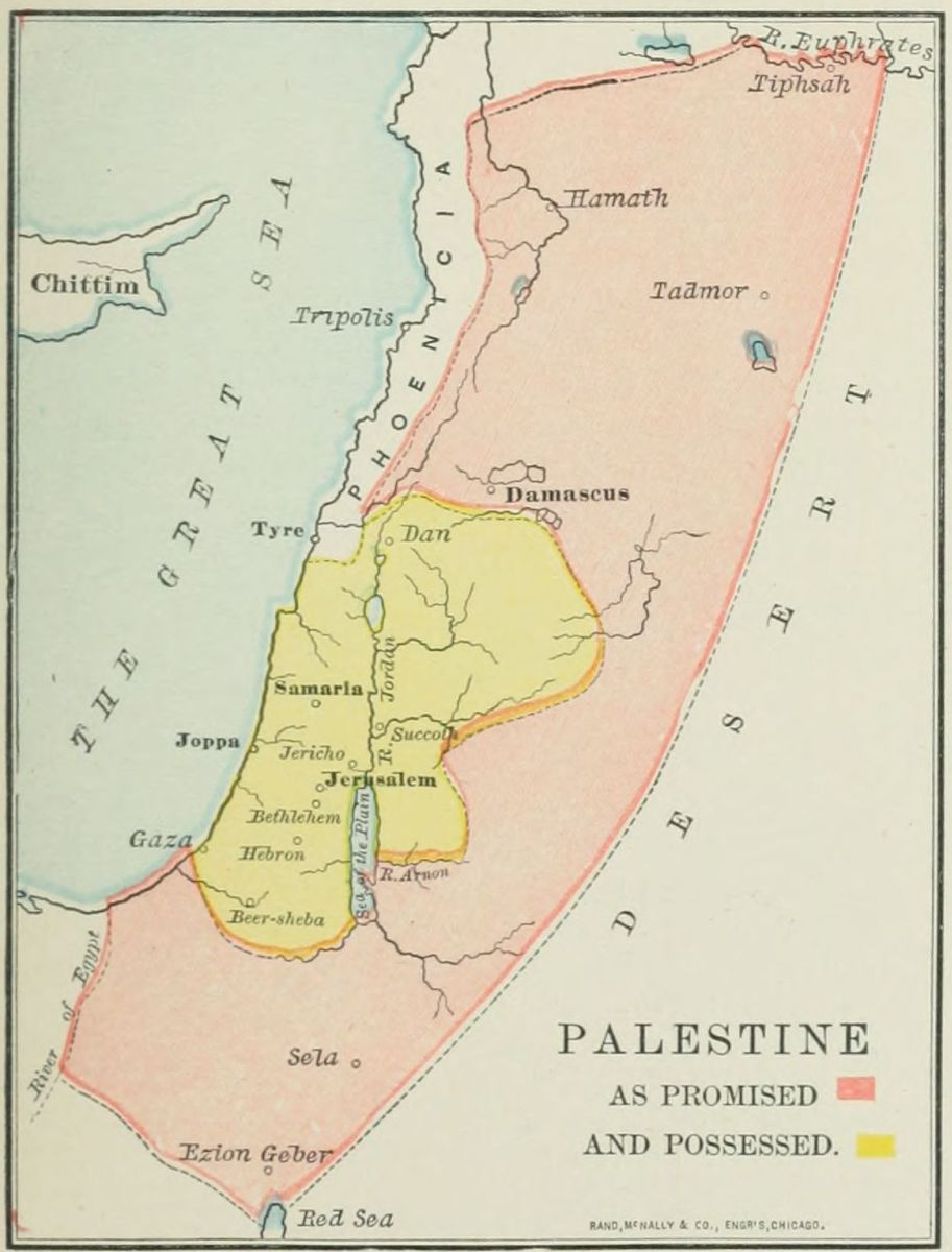
2. The Conquest of Southern Palestine. (Josh. 10.) The conquest had thus far been easy; mainly because there was no union among the native tribes, but each city and village was ruled by its own "king," or sheikh, and all were jealous of one another, so that they were readily conquered in detail. Warned by the fate of Jericho and Ai, and alarmed at the defection of Gibeon, the kings of five cities formed a league to resist the invading host. The head of the confederation was Adoni-zedek, the king of Jerusalem, and associated with him were the rulers of Hebron, Jarmuth, Lachish and Eglon, and perhaps other subordinate chiefs. They began by an attack on the city of Gibeon, as a tributary of Israel. Joshua at once called forth his warriors, left the camp at Gilgal, made a swift night march through the mountain passes, and came suddenly upon the enemy near Beth-horon. Here was fought perhaps the most important battle in all human history, and one at which "the sun and moon" might well "stand still," since the religious destiny of all the world was at stake in its result. In this one battle the conquest of Canaan was made certain, though it was not fully accomplished until long afterward. The flying host were pursued to Makkedah, on the border of the plain, where the five kings were captured and slain. Then in succession, the strongholds of Libnah, Lachish, Eglon, Hebron, and, last of all, Debir, were taken by storm. From the list of the kings captured (Josh. 12:9-24), it would appear[53] that Joshua carried his conquests through the South Country, as far as Arad and Hormah, places where the Israelites had suffered defeat during the period of the wandering (Num. 21:1-3); though these kings may have been captured at Hebron or Debir. But, though all may not have been ravaged by the Israelites, all was certainly conquered, from Jerusalem to the great desert on the south. The conquest was afterward made complete by the aged Caleb, who with his nephew Othniel took possession of the very cities of which the name had filled the Israelites with terror a generation before. (Num. 13.)
3. The Conquest of Northern Palestine. (Josh. 11.) This region was also occupied by a number of independent chiefs, of whom the most powerful was Jabin, the king of Hazor, a title which afterward reappears in the history. (Judges 4, 2.) They ruled over small tribes of various races, from Mount Hermon to Mount Carmel, especially on the Plain of Esdraelon. The king of Hazor called together the associated tribes, and their camp was pitched near Lake Merom. Joshua made one of his characteristic swift marches, up the Jordan Valley, attacked them suddenly, and utterly defeated and scattered them. He burned the many war chariots, and so cut the sinews of their horses as to make them useless; since these animals were never used by the Israelites. After the battle he marched through the northern regions, capturing the cities and slaying their rulers, a number of whom are mentioned in the catalogue of Josh. 12:9-24. This campaign closed the active operations, so that "the land rested from war" (Josh. 11:23); but for many years the strife was feebly continued, and it was not entirely finished until the reign of David.
III. SUPPLEMENTARY CONQUESTS.
Although the struggle of the conquest was over, yet in most of the land the task of expulsion or destruction was yet to be accomplished, and in many places was never entirely wrought. The entire section of the maritime plain remained in the hands of the Philistines; in almost every tribe were fortresses, which long resisted the Israelites, and formed centres of rebellion, and sometimes of oppression. And many of the cities taken by Joshua were soon reoccupied by their original inhabitants, and once more fortified. The book of the Judges relates briefly three campaigns after the conquest.
1. The Campaign of the Judaites and Simeonites. (Judges 1:1-8.) This was undertaken against Adoni-bezek, the king of Bezek, a place in or near the tribe of Judah, not positively identified. Adoni-bezek was a petty chieftain, who had cruelly mutilated no less than 70 local chiefs whom he had taken in battle. He was surprised by the allied forces of Judah and Simeon, and ten thousand of his warriors were slain. He was taken prisoner, and treated as he had treated other captive kings; his thumbs and great toes being cut off, thus making him helpless. After this, the allied tribes marched down upon the maritime plain, and took the Philistine cities of Gaza, Ashkelon and Ekron. But their conquests were not permanent; they withdrew to the mountains, and the Philistines were soon in possession of their cities, which long stood as a menace to Israel. Another campaign was directed against the cities of the Negeb, or South Country, and resulted in the destruction of Zephath and Hormah, both south of Hebron.
2. The Campaign of Caleb and Othniel. Caleb was the oldest man in Israel, having accompanied Joshua and the other spies, thirty-eight years before the entrance of Israel into the Promised Land. (Num. 13-14.) For his faithfulness when so many were overcome with terror, he received a promise of inheritance in the land. At least 45 years afterward, Hebron, in the south of Judah, was allotted to him. It had been taken by Joshua (Josh. 10:36, 37), but afterward reoccupied by the Anakim (see page 38), and the Amorites, its original possessors. Caleb led an army against it, once more won the city, and made it his own. He promised his daughter, Achsah, to the warrior who should take Debir, or Kirjath-sepher, south of Hebron, which had also been reoccupied by the enemy. His younger brother (perhaps nephew) Othniel, won the city and his bride. (Josh. 14:1-15; 15:13-19; Judges 1:10-15.) This campaign was probably about the same time with the one narrated above, and may have been in connection with it.[54]
3. The Danite Campaign. (Judges 18.) The tribe of Dan found themselves unable to overcome their Philistine neighbors, and were straitened for room in their narrow possessions. They sent out a body of men to search for a new home. These spies traversed the country as far to the north as Laish, or Leshem, a Phœnician city, near one of the sources of the Jordan. The Danite spies returned to their people at Zorah and Eshtaol, and made their report. A part of the tribe agreed to migrate to this northern region. Their first encampment on the journey, near Kirjath-jearim, in Judah, long bore the name of "the camp of Dan." At a village in Mount Ephraim they plundered Micah of his idols and carried away their priest, who was a degenerate grandson of Moses the prophet. At Laish they fell suddenly upon the defenseless Phœnicians, destroyed their city, and built in its place one which they called Dan. It was the northern landmark of the land, as Beersheba was its southern, giving rise to the term "from Dan to Beersheba." Dan remained an idol sanctuary, and a place of corrupting influence during all the after history of Israel.
No comments:
Post a Comment