II. The Biblical Jewish Diaspora

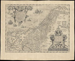
The Hebrew peoples were originally nomadic. Their origins lie with the Patriarch Abraham and his migration from Mesopotamia to the Promised Land of Canaan, where his followers and descendants settled [4]. His wanderings are traced in the small inset map (upper left). The larger map depicts the ancient tribal divisions of the Land of Canaan as described in Genesis. The decorative border of this historical reconstruction, engraved by the Flemish cartographer Ortelius in 1586, contains twenty-two medallions portraying scenes from the life of Abraham. After the enslavement of the Hebrews in Egypt, Moses led them back to their “promised land” in the Exodus of ca. 1200 bce, establishing the pattern of return to a national homeland which is so central to Jewish culture and history [5]. (Exodus outlined in red.)
Palestinae Sive Totivs Terrae Promissionis Nova Descriptio Avctore Tilemanno Stella Sigenens
Abraham Ortelius (Flemish, 1527-1598)
Palestinae Sive Totivs Terrae Promissionis Nova
Descriptio Avctore Tilemanno Stella Sigenens
Copper engraving, 34.2 x 45.9cm
From Parergon (Antwerp: Plantijn, 1579)
Osher Collection
Palestinae Sive Totivs Terrae Promissionis Nova
Descriptio Avctore Tilemanno Stella Sigenens
Copper engraving, 34.2 x 45.9cm
From Parergon (Antwerp: Plantijn, 1579)
Osher Collection
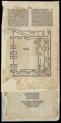
[Eretz Israel]
These Biblical events have long been the subject of historical reconstructions by both Jewish and Christian scholars. They have been defined by the way in which those scholars interpreted the meaning of the events. One of the earliest Hebrew printed maps of the Holy Land was created in 1523 by Rabbi Mizrachi whose parents had taken refuge in Ottoman Turkey after the expulsion of the Jews from Spain. The map is based on places mentioned in the book of Deuteronomy in the Old Testament. It represents the Holy Land as an abstract, schematic image with east at the top and the land of Israel (Eretz Israel) in the center. [6]
Rabbi Elia Mizrachi (Turkish, ca. 1450-1526)
[Eretz Israel]
Woodcut, 5.7 x 14.5cm
From [A Biblical Commentary] (Venice, 1523)
Osher Collection
[Eretz Israel]
Woodcut, 5.7 x 14.5cm
From [A Biblical Commentary] (Venice, 1523)
Osher Collection
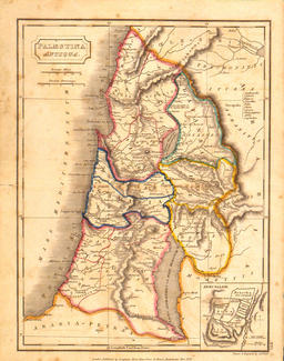
Palestina Antiqua
The Hebrews divided Canaan among the twelve tribes which were eventually unified into a single Hebrew Kingdom, ca. 1000 bce . In this nineteenth century historical reconstruction [7], the political and tribal divisions are outlined in color. (The tribal names are highlighted in red.)
Sidney Hall (English, fl. 1817-1860)
Palestina Antiqua
Lithograph, hand-colored, 23.9 x 19.5cm
From Samuel Butler, A Sketch of Modern and
Ancient Geography for the use of schools
(London: Longman, Horst, et. al., 1822)
Smith Collection
Palestina Antiqua
Lithograph, hand-colored, 23.9 x 19.5cm
From Samuel Butler, A Sketch of Modern and
Ancient Geography for the use of schools
(London: Longman, Horst, et. al., 1822)
Smith Collection
Interpreting the Maps of Diaspora
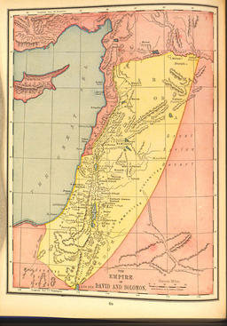
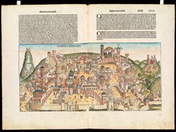
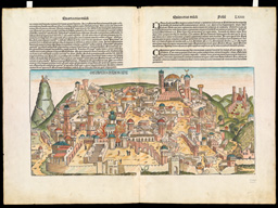
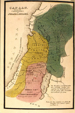
In the eighth century bce, the kingdom split into the northern and southern kingdoms of Israel and Judah, from which the name “Jew” is derived. These kingdoms were subsequently conquered by the Babylonians in 722 bce and the Assyrians in 586 bce [10]. In the process, Jerusalem and the Temple were repeatedly destroyed [9] and the Jews were enslaved and scattered throughout the empires of the Middle East [Diagrams A-B]. Although some Jews returned to rebuild the Temple, many remained in exile. These dispersals have collectively been called the Diaspora (from the Greek for “scattering”) and the term now refers to a forced migration. A composite view of Jerusalem appeared in the Nuremberg Chronicle, a history of the world from Creation to the time of the book’s publication in 1493. In this illustration [9], the six major destructions of Jerusalem are depicted as a cycle of destruction and renewal: Solomon’s Temple is in flames in the left foreground, destroyed by the Babylonians; the Church of the Holy Sepulchre, which was established a thousand years later is shown at the upper center. It was severely damaged in 1099 but was soon rebuilt during the first Crusade. In the nineteenth century, the Babylonian and Assyrian captivities were depicted as analogous to the eighteenth-century division of Poland [10], while in the twentieth century, the kingdom of David and Solomon is presented as a secular rather than religious entity [8].
Rand McNally & Co (American Firm, 1862-)
The Empire of David and Solomon
Color offset, 26.0 x 19.7cm
From A Bible Atlas
(New York: Rand McNally & Co., 1948)
Osher Collection
The Empire of David and Solomon
Color offset, 26.0 x 19.7cm
From A Bible Atlas
(New York: Rand McNally & Co., 1948)
Osher Collection
Canaan Shewing the Captivities of Judah & Israel
Richard Palmer (American, fl. 1836)
Canaan Shewing the Captivities of Judah & Israel
Copper engraving transferred to lithograph, 14.2 x 9.2cm
Facsimile from The Bible Atlas or Sacred Geography Delineated
(New York: Leavitt, Lord & Co., 1836)
Smith Collection
Canaan Shewing the Captivities of Judah & Israel
Copper engraving transferred to lithograph, 14.2 x 9.2cm
Facsimile from The Bible Atlas or Sacred Geography Delineated
(New York: Leavitt, Lord & Co., 1836)
Smith Collection

No comments:
Post a Comment